GEOGRAPHY, POPULATION AND WATER RESOURCES
Ghana, located in western Africa, has a total area of 238 540 km² The cultivable area is about 100 000 km² which is 42% of the total area. The cultivated area is about 11 400 km² which is 4.8% of the total area and 11.4% of the cultivable area.
The population is estimated to be almost 17 million (1994), of which 66% is rural. The average population density is 71/km², but ranges from 20/km² in the Northern Province to 575/km² in the Greater Accra province. The population growth rate was estimated at 3.5% per year during the period 1984 to 1991.
TABLE 1
Basic statistics and population
| Area of the country | 1994 | 23 854 000 ha |
| Cultivable land | 1990 | 10 000 000 ha |
| Cultivated land | 1990 | 1 140 000 ha |
| Total population | 1994 | 16 944 000 inhab. |
| Population density | 1994 | 71 inhab./km² |
| Rural population | 1990 | 66 % |
| Water supply coverage | ||
| Urban population | 1990 | 90 % |
| Rural population | 1990 | 29 % |
Agriculture contributed 44.7 % to the GDP in 1994.
Water resources
Average rainfall is about 1 264 mm/ year, but ranges from 890 mm/year in the coastal zone near Accra to 2 030 mm/year in the southwestern rainforests. The rainfall is bi-modal in the southwestern forest zone, giving a major and a minor growing season; elsewhere, a uni-modal distribution gives a single growing season from May to October. Except for the southwestern zone, the reliability of the rainfall, particularly after crop germination, is a major factor affecting crop growth.
Global water resources are estimated at 53.2 km³ per year, consisting of 30.3 km³/year, of internally produced water resources and 22.9 km³/year, of runoff from other countries.
The drainage network of Ghana is divided into three main systems: the Volta river system, the southwestern river basins, and the coastal rivers.
TABLE 2
Water balance
| Water resources: | |||
| Average precipitation | 1 264 | mm/yr | |
| 301.7 | km³/yr | ||
| Internal renewable water resources - total | 30.3 | km³/yr | |
| Internal renewable water resources - per caput | 1994 | 1 788 | m³/yr |
| Global renewable water resources | 53.2 | km³/yr | |
| Dependency ratio | 43.0 | % | |
| Total dam capacity | 1994 | 148.5 | km³ |
| De-salinated water | - | 10 6 m³/yr | |
| Water withdrawal: | |||
| - Agricultural | 1970 | 156 | 10 6 m³/yr |
| - Domestic | 1970 | 105 | 10 6 m³/yr |
| - Industrial | 1970 | 39 | 10 6 m³/yr |
| Total | 300 | 10 6 m³/yr | |
| per caput | 1970 | 35 | m³/yr |
| as % of internal renewable water resources | 1.0 | % | |
| Other withdrawal | - | 10 6 m³/yr | |
| Wastewater: | |||
| Produced | - | 10 6 m³/yr | |
| Treated | - | 10 6 m³/yr | |
| Re-used treated wastewater | - | 105 m³/yr |
TABLE 3
Irrigation and drainage
| Irrigation potential | 1994 | 1 900 000 | ha |
| Irrigation: | |||
| 1. Full or partial control Irrigation: equipped area | 1994 | 6 374 | ha |
| - surface irrigation | 1994 | 5 794 | ha |
| - sprinkler irrigation | 1994 | 580 | ha |
| - micro-irrigation | 1994 | 0 | ha |
| % of area irrigated from groundwater | 1994 | 0 | % |
| % of area irrigated from surface water | 1994 | 100 | % |
| % of equipped area actually irrigated | 1994 | 61 | % |
| 2. Spate irrigation area | - | ha | |
| 3. Equipped wetland and inland valley bottoms | - | ha | |
| 4. Other cultivated wetland and inland valley bottoms | - | ha | |
| 5. Flood recession cropping area | - | ha | |
| Total water managed area (1 + 2 + 3 + 4 + 5) | 1994 | 6 374 | ha |
| - as a % of cultivated area | 1994 | 0.6 | % |
| - increase over last 10 years | - | % | |
| - power irrigated area as % of water managed area | 1994 | 57.6 | % |
| Full or partial control schemes: Criteria | |||
| Large schemes > 500 ha | 1994 | 4 720 | ha |
| Medium schemes | 1994 | 1 204 | ha |
| Small schemes < 100 ha | 1994 | 450 | ha |
| Total number of households in irrigation | |||
| Irrigated crops: | |||
| Total irrigated grain production | - | t | |
| as % of total grain production | - | % | |
| Harvested crops under irrigation | - | ha | |
| - rice | - | ha | |
| - vegetables | - | ha | |
| - maize | - | ha | |
| Drainage - Environment: | |||
| Drained area | - | ha | |
| as % of cultivated area | - | % | |
| Flood-protected area | - | ha | |
| Area salinized by irrigation | 1992 | 1 480 | ha |
In the urban areas, 90 % of the population has access to piped drinking water, while only 29 % of the rural population has access to safe drinking water. Total water withdrawal was estimated at 0.3 km³ in 1970 (Figure 1).
IRRIGATION DEVELOPMENT
The potential for irrigated rice production in the Inland Valley Swamps (IVS) and river flood plains is about at 1.9 million ha in Ghana, according to the World Bank's estimate. The potential for full control irrigation development, based on soil and water availability, is estimated at 346 000 ha.
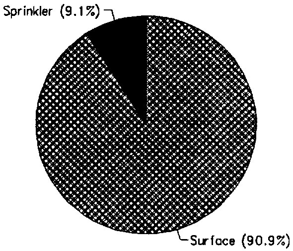
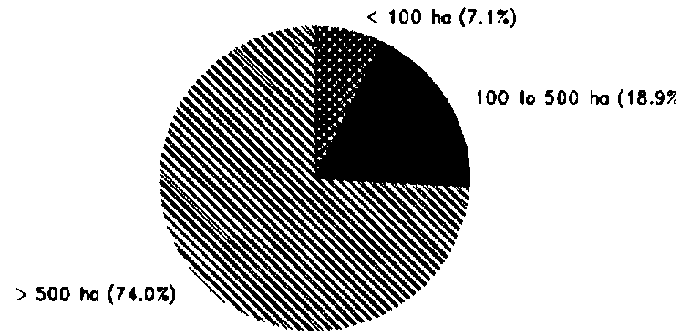
The Total water managed area is about 6 374 ha. In fact, this area corresponds to the full or partial control irrigated area, as there are no data relative to the existing wetlands and IVS. On the major part (5 794 ha), surface irrigation is practiced, while sprinkler irrigation is used on 580 ha (Figure 2). Large-scale irrigation schemes (> 500 ha) cover 4 720 ha; medium-scale irrigation schemes (100-500 ha) cover 1 204 ha, while small-scale schemes (< 100 ha) cover 450 ha (Figure 3). The developed area is solely irrigated by surface water (Figure 4), through gravity, pumping or a combination. The area actually irrigated is only 3 920 ha, as a large part of the equipped area is not currently in use.
Average yield for irrigated rice is 5 to 6.5 t/ha, compared with yields of between 1.0 and 1.5 t/ha under uncontrolled conditions. The major irrigated crop is rice, followed by tomato, okra, pepper, aubergine, cowpea and maize.
FIGURE 1: Water withdrawal (total: 0.3 km³ in 1970)
FIGURE 2: Irrigation techniques, full or partial control (1994)
FIGURE 3: Types of full or partial control irrigation schemes (1994)
Costs of irrigation development vary widely -from about $US 5 000 to 50 000/ha, while the threshold level for irrigation investment should not be more than $US 6 200/ha based on 1989 rice prices. Projects such as Ashaiman, Afife, yea, Aveyima and Weija cost between $US 5 000 and 14 000/ha, whilst costs for Tono and Bantanga were between $US 40 000 and 50 000/ha due to the lie of the land. Typical costs are about $US 2 500/ha for water conservation projects, and between $US 4 000 and 6 500/ha for small schemes of about 100 ha that use pumps.
INSTITUTIONAL ENVIRONMENT
Ghanaian irrigation development is dominated by the public sector. The Ghana Irrigation Development Authority (GIDA) was, until recently, the sole agency involved in the management of the schemes. GIDA provided all agricultural inputs and extension services. It operated and maintained the system, delivered the water to the farmer's fields and secured credit. The comprehensive involvement of GIDA has been cited by the World Bank as one of the causes of poor performance in the majority of the irrigation projects. Therefore, GIDA is testing the concept of fully involving the beneficiary groups in project identification, construction and management, through the establishment of Cooperative Societies. In the future, communities wishing to have new irrigation projects must form Cooperative Societies to show their commitment. GIDA will train the farmers, and the extension staff of the Ministry of Food and Agriculture will be based in the project, which approach should ensure sustainability following the departure of GIDA after 3-4 years. However, GIDA may provide backstopping when necessary.
TRENDS IN WATER RESOURCES MANAGEMENT
The utilization of the irrigation potential and improvement in irrigation output are constrained by the following obstacles:
FIGURE 4: Origin of irrigation water, full or partial control (1994)
The nature of the land and surface water resources makes the potential for further development of large-scale irrigation schemes costly. A cheaper alternative could be development of small-scale IVS projects (fadamas) and river flood plains. These areas are suitable for rice cultivation and irrigable by shallow groundwater or controlled flooding. However, the accelerated sedimentation that would be generated from these areas by natural processes and by agricultural activities due to the introduction of irrigation will need to be controlled, inter alia, by improved tillage systems. If this is not done, then the intensive development of inland valley bottoms and river flood plains could lead to rapid siltation of the water channels and dams.
MAIN SOURCES OF INFORMATION
Ministry of Agriculture. 1991. Agriculture in Ghana, Facts and figures.
Rural Water Supply Ghana. 1991. Rural water supply and sanitation section strategy.
Statistical Service. 1984. Population census of Ghana: Demographic and Economic.
Water Resources Research Institute/FAO. 1993. Survey on water use for agricultural and rural development.
World Bank. 1990. Ghana Medium-term Agricultural Development Programme.