![]()
![]()
![]()
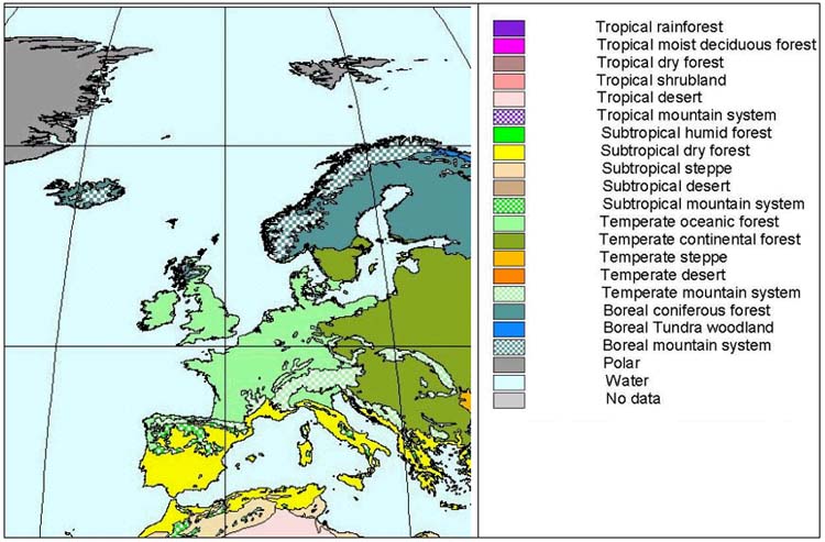
Figure 27-1. Northern, central and southern Europe: ecological zones
Figure 27-1 and Figure 27-2 show the distribution of ecological zones in Europe. Table 27-1 contains area statistics for the zones by subregion and Table 27-2 indicates the proportion of forest in each zone by subregion.
SUBTROPICAL DRY FOREST
In Europe, subtropical dry forests are found in the Mediterranean region below 800 m altitude, including the Iberian Peninsula (except the northern part), Rhone Basin, Apennines Peninsula, Dalmatia and Greece, as well as all the European islands of the Mediterranean Sea. The distribution of Olea europaea and Quercus ilex roughly defines their boundary.
The Mediterranean climate provides dry, warm summers and cool, moist winters without severe frosts. Precipitation maxima are normally in November/December and February/March. Pronounced elevational relief produces substantial local differentiation. Average annual precipitation is between 400 and 900 mm, rarely above 1 200 mm (e.g. Kerkira) or below 400 mm (southeastern Spain, southeastern Crete). The amount of precipitation decreases slightly to the east. The average temperature of the warmest month is between 25° and 28°C, that of the coldest month between 6° and 13°C.
The original vegetation was evergreen sclerophyllous forest but much of it has long been impacted by anthropogenic influences. The tree species composition is usually rather monotonous. Only one species typically dominates the canopy, often one of the evergreen oak species. Quercus ilex and its various subspecies compete most successfully on humid and subhumid sites. Under a 15 to 18 m tall tree layer with a closed canopy is usually a 3 to 5 m tall shrub layer.
SUBTROPICAL MOUNTAIN FOREST
This zone includes the Iberian mountains (Cordillera Cantabrica, Sistema Central, Sistema Iberico, Penibética, Pyrenees), the Apennines, the Greek mountains (Pindus, Olympus, Peleponnesus, Crete), as well as the mountains of Corsica and Sardinia. The zone starts at about 600 to 800 m and extends up to 2 000 m, locally to 3 500 m.
Figure 27-2. Belarus, Republic of Moldova, Russian Federation and Ukraine: ecological zones
The region is characterized by higher precipitation and a shorter summer drought period than the adjacent lowland region. Temperatures are lower with a greater frequency of frosts.
In contrast to the dry sclerophyllous forests, the vegetation of this zone is typically deciduous oak species. These forests are usually quite closed and shady. On the Iberian Peninsula, Quercus pyrenaica forests dominate on siliceous bedrock, while Q. faginea occupies base-rich sites. In the Pyrenees and eastwards, Quercus pubescens and other oak species become more important. Closed and shady Fagus sylvatica forests, partly with Abies alba or Picea abies, locally with Betula pubescens, replace the deciduous oak forests at higher elevations. In the Greek Pindus Mountains, Abies borisii-regis replaces Abies alba and is often the dominant species. At even higher altitudes the oak and beech forests are replaced by juniper and cypress woodland (Juniperus thurifera, J. excelsa, J. foetidissima, J. polycarpos, Cupressus sempervirens) or by pine (Pinus nigra), as well as fir forests (Abies pinsapo on the Iberian Peninsula, A. cephalonica in Greece).
TEMPERATE OCEANIC FOREST
The temperate oceanic forest zone combines spatially separated areas and comprises the Portugal-Spain coastline (Galicia, Asturia, Cantabrica, Euskal), the British Isles except for the Scottish Highlands and the mountainous regions, France apart from the southeastern mountainous and Mediterranean parts, Central Europe west of a rough line Danzig-Erfurt-Vienna and south of the Alps, including the Po plain. In Scandinavia, all of Denmark, southernmost Sweden and a narrow strip along the coast of Norway are included. Additionally, some climatically sheltered fjords up to 64°N belong to this zone.
The climate is influenced by the Gulf Stream and the proximity to the ocean. The influence decreases inland and is replaced in the Po plain by a different climatic parameter with similar effects. The average annual temperature ranges from 7° to 13°C and annual rainfall varies from 600 to 1 700 mm. While in coastal areas the temperature of the coldest month does not fall below 0°C, inland mean temperature is locally below 0°C.
Various types of beech forests (Fagus sylvatica) and mixed beech forests are the dominant vegetation. These are most extensive in Germany and neighbouring countries. Pure beech forests are relatively dense. In oceanic areas, Ilex aquifolium is a characteristic species of the shrub layer. On nutrient-poor, acidic soils beech is partly mixed with Quercus robur and Quercus petraea in the canopy. These stands are poor in species. Today, natural beech forests have been extensively converted into farmland or have been transformed into mixed oak-hornbeam forests. Large areas have been reforested with spruce (Picea spp.) and Douglas fir (Pseudotsuga spp.).
Outside the distribution area of beech, oak-ash forests (Quercus robur, Fraxinus excelsior) with Corylus avellana occupy base-rich, often calcareous soils. Oak-hornbeam forests (Quercus petraea, Carpinus betulus) dominate periodically moist soils. They often have a distinct vertical structure with a canopy and subcanopy. South of the Alps, Quercus cerris may occur together with oak and hornbeam. In the southwest of the zone, Quercus pubescens forests occupy areas with a milder climate.
Table 27-1. Europe: extent of ecological zones
|
Subregion |
Total area of ecological zone (million ha) |
|||||||||||||||||||
|
Tropical |
Subtropical |
Temperate |
Boreal |
Polar |
||||||||||||||||
|
Rain forest |
Moist |
Dry |
Shrub |
Desert |
Mountain |
Humid |
Dry |
Steppe |
Desert |
Mountain |
Oceanic |
Continental |
Steppe |
Desert |
Mountain |
Coniferous |
Tundra |
Mountain |
||
|
Belarus, Rep. Moldova, Russian Fed. and Ukraine |
|
|
|
|
|
|
|
|
|
|
|
|
247 |
119 |
9 |
42 |
553 |
141 |
476 |
205 |
|
Southern Europe |
|
|
|
|
|
|
|
76 |
|
|
15 |
10 |
42 |
3 |
|
20 |
|
|
|
|
|
Northern Europe |
|
|
|
|
|
|
|
|
|
|
|
3 |
30 |
|
|
|
69 |
|
36 |
|
|
Central Europe |
|
|
|
|
|
|
|
|
|
|
|
117 |
51 |
|
|
24 |
1 |
|
1 |
|
|
Total Europe |
|
|
|
|
|
|
|
76 |
|
|
15 |
130 |
371 |
122 |
9 |
87 |
624 |
141 |
513 |
206 |
|
TOTAL WORLD |
1 468 |
1 117 |
755 |
839 |
1 192 |
459 |
471 |
156 |
491 |
674 |
490 |
182 |
726 |
593 |
552 |
729 |
865 |
407 |
632 |
564 |
Note: Data derived from an overlay of FRA 2000 global maps of forest cover and ecological zones.
Table 27-2. Europe: proportion of forest by ecological zone
|
Subregion |
Forest area as proportion of ecological zone area (percentage) |
|||||||||||||||||||
|
Tropical |
Subtropical |
Temperate |
Boreal |
Polar |
||||||||||||||||
|
Rain forest |
Moist |
Dry |
Shrub |
Desert |
Mountain |
Humid |
Dry |
Steppe |
Desert |
Mountain |
Oceanic |
Continental |
Steppe |
Desert |
Mountain |
Coniferous |
Tundra |
Mountain |
||
|
Belarus, Rep. Moldova, Russian Fed. And Ukraine |
|
|
|
|
|
|
|
|
|
|
|
|
35 |
8 |
|
74 |
72 |
19 |
55 |
3 |
|
Southern Europe |
|
|
|
|
|
|
|
53 |
|
|
38 |
34 |
29 |
|
|
63 |
|
|
|
|
|
Northern Europe |
|
|
|
|
|
|
|
|
|
|
|
48 |
57 |
|
|
|
70 |
|
22 |
|
|
Central Europe |
|
|
|
|
|
|
|
|
|
|
|
20 |
24 |
|
|
59 |
|
|
|
|
|
Total Europe |
|
|
|
|
|
|
|
53 |
|
|
38 |
22 |
35 |
8 |
|
67 |
71 |
19 |
53 |
3 |
|
TOTAL WORLD |
69 |
31 |
64 |
7 |
0 |
26 |
31 |
45 |
9 |
2 |
20 |
25 |
34 |
4 |
1 |
26 |
66 |
26 |
50 |
2 |
Note: Data derived from an overlay of FRA 2000 global maps of forest cover and ecological zones.TEMPERATE CONTINENTAL FOREST
This zone has a roughly triangular shape with the corners in Oslo, Sofia and Ufa. Southern Sweden, eastern Europe south of the line Helsinki-Novgorod-Perm and north of the line Bucharest-Charkov-Ufa are included. Additionally, most of the Balkan Peninsula and the foothills of the Crimean and Caucasus Mountains are part of the zone.
Owing to less influence of the Gulf Stream, annual rainfall gradually decreases from the west (about 700 mm) to the east (about 400 mm). Summers are warm and winters are cold in most of this region. Mean annual temperature is about 6° to 13°C in the west and decreases to 3° to 9°C in the east. The temperature of the coldest month ranges from below 0°C in Scandinavia and around 0°C in the Balkans to below -10°C in the Ural Mountains. In the northern parts of the zone, more than two months of the year have a mean temperature below 0°C. Additionally, precipitation diminishes from the northwest (greater than 700 mm) to the southeast (400 mm). Locally, in the foothills of the Caucasus, rainfall is very high.
The zone has various forest types, distributed along local and regional gradients of climate and nutrient availability. In the northern parts, mixed coniferous broad-leaved forests form a belt parallel to the circle of latitude. Spruce forests (Picea abies) constitute most of the forest cover. On more acidic and drier soils pine forests replace spruce.
Further south, deciduous broad-leaved forests are represented by mixed oak-hornbeam and mixed lime-oak forests. The mixed oak-hornbeam forests include Quercus robur, Quercus petraea, Carpinus betulus and Tilia cordata. Associated species such as Fraxinus excelsior and Acer campestre are also important. Mixed lime-oak forests are found east of the distribution boundary of mixed oak-hornbeam forests. Quercus robur and Tilia cordata predominate in the tree layer. Land clearing has massively decimated this type of forest.
Sessile oak, bitter oak (Quercus petraea) and Balkan oak (Quercus spp.) forests occur mainly in southeastern Europe and the Balkan countries. These species-rich, more open, mixed forests, dominated by Quercus cerris and Quercus frainetto, occupy the central part of the Balkan Peninsula. Today, these formerly dense forests have been greatly reduced and isolated after long exploitation under the coppice with standards system and for agricultural uses.
Swamp and fen woods occur in small patches across the entire zone. Extensive areas of this vegetation still exist in the lowlands of Poland and Belarus. On permanently wet sites the dominant tree species is Alnus glutinosa in association with Picea abies.
Flood-plain vegetation is prominent along the middle sections and lower courses of the large rivers Rhine, Elbe, Oder, Vistula, Pripet, Desna, Volga, Save and Danube. Owing to long-term inundation, willow and poplar alluvial forests (Salix alba, Salix fragilis, Populus nigra and Populus alba) are rather poor in species. Hardwood flood-plain vegetation is highly varied in structure with Quercus robur, Fraxinus excelsior, Ulmus minor, Ulmus laevis and Fraxinus angustifolia (in southeastern Europe). River regulation and embankment have resulted in a severe decline of near-natural habitat and nowadays only fragments of original flood-plain forests remain.
TEMPERATE MOUNTAIN SYSTEMS
This zone consists of the mountainous parts of the temperate domain, including the Cantabrican Mountains, Pyrenees, Massif Central, Jura, Alps, the highest sites of the British Isles mountains, the Central European uplands, Carpathians, Dinaric Alps, Balkan mountains, Rhodope Mountains, the High and Low Caucasus and the foothills of the Talysh Mountains as well as the southern Urals.
As the highest altitudinal belt of the temperate domain the mountain region is characterized by generally greater precipitation and lower temperature, the climate is extremely varied. Precipitation varies from less than 500 mm to more than 3 000 mm. The average annual temperature ranges from -4° to 8°C (locally 12°C) and the average January temperature at the highest altitudes fluctuates between -10° and -4°C.
Beech (Fagus spp.) forests, particularly mixed beech forests with Abies alba, Picea abies, Acer pseudoplatanus, Fraxinus excelsior and Ulmus glabra, comprise the vegetation of the lower belt in this region. As in the oceanic region, pure beech forests at higher altitudes are relatively dense. At higher altitudes, other tree species become more prominent. To the east Fagus sylvatica (subsp. sylvatica) is replaced by Fagus sylvatica subsp. moesiaca and further eastwards by F. sylvatica subsp. orientalis.
At even higher altitudes, fir and spruce forests (Abies alba, A. borisii-regis, A. nordmanniana, Picea abies, P. orientalis and P. omorika) replace the beech forests. Either Abies or Picea may dominate. Pinus sylvestris, Fagus sylvatica, some Quercus robur, and pioneer species such as Sorbus aucuparia, Populus tremula and Betula pendula play a minor role. Around the timberline, pine scrub (Pinus mugo) or Rhododendron spp. may occur. This scrub and krummholz grades at higher altitudes into alpine grasslands, various dwarf shrub vegetation and rock and scree vegetation of the alpine to nival belt.
In the Urals, the altitudinal zonation starts with lime-oak forests (Quercus robur, Tilia cordata) at the lowest level followed by herb-rich fir-spruce forests (Abies sibirica, Picea obovata) with broad-leaved trees such as Ulmus glabra and Tilia cordata as well as pine forests (Pinus sylvestris) with Larix sibirica.
BOREAL CONIFEROUS FOREST
This zone occurs in some parts of Norway, most of Sweden, nearly all of Finland, northern Scotland and a wide belt in the western part of the Russian Federation south of the Arctic Circle as well as the southern part of Iceland. The zone also covers major areas in the eastern parts of the Russian Federation. A small island of lowland boreal forest is in the Russian Far East, north of the Amur River.
The western part of the zone has a cool-temperate, moist climate, varying from oceanic in the west to subcontinental in the interior and the east. Mean annual temperature is generally low and ranges from 8°C in Scotland to just above 1°C in the northern parts of the Russian Federation. Precipitation ranges from more than 900 mm in the west to 400 mm in the east, with extremes of 1 200 and 300 mm. A short growing period (less than 120 days) is characteristic. Evaporation is low and prolonged periods of drought are rare. Snow generally covers the ground for several months during the winter.
The climate of boreal western Siberia is influenced by the amount of solar energy, the Atlantic Ocean to the west and the powerful east Siberian winter anticyclone from the east. The climate of the northern part is under the influence of arctic atmospheric processes. To the south, the low winter temperature contrasts a relatively high summer temperature. The maximum precipitation (on average 500 mm) is in the centre of the plain (about 60°N); to the north and south the amount of precipitation is lower. Throughout the zone, rainfall is concentrated during the growing period or warm season. Snow cover plays a significant role in western Siberia, defining the depth of frozen soils in winter and determining hydrology in summer.
In western Siberia, the average annual temperature is about -4°C (January, -22° to -24°C; July, 16° to 17°C), the growth period is about 85 days, the period with snow cover 190 to 200 days and annual precipitation 410 to 450 mm. To the south, the climate becomes significantly warmer. Between the Irtish and Yenisey Rivers, the average annual temperature increases to -0.4° to -1°C (January, -18° to -21°C; July, 16.5° to 18°C), the growth period to 100 to 115 days, snow cover 175 to 190 days and precipitation 410 to 550 mm.
In the sparse taiga of the eastern part of the middle Siberian Plateau the climate is continental, with little precipitation, dry springs and severe winters. The average annual temperature is -11° to -13°C (January, -38° to -43°C; July, 14° to 17°C), the growth period is 63 to 73 days, snow cover is 228 to 237 days and precipitation 200 to 290 mm. A major part of this area is covered by continuous permafrost, very deep (up to 600 m) and cold (-8° to -12°C) in the north, which crucially impacts the structure and functioning of forest ecosystems. The melting layer is from 0.2 to 0.5 m on wetlands and up to 0.5 to 0.8 m on drained sites.
The glaciers of northern Europe essentially wiped the land clean of most plant species. This great natural perturbation is still reflected in the species and vegetation diversity of the region. Most boreal forests are dominated by only a few conifer tree species, primarily spruce (Picea abies) on moister ground and pine (Pinus sylvestris) on drier ground. East of the White Sea, mainly closer to the Ural Mountains, Siberian conifer species such as Pinus sibirica, Abies sibirica and Larix sibirica may also occur. Deciduous species such as birch (Betula spp.), aspen (Populus tremula), alder (Alnus spp.) and willow (Salix spp.) are characteristic of the early successional stages (especially birch and aspen) or may form smaller stands among the conifers. Stands of deciduous trees are mainly associated with special habitats, often disturbed by fire or floods, or occupy particular soils.
Mires form characteristic landscape elements in mosaics with various forest types. In parts of northern Finland, mires cover almost 50 percent of the land area. Raised bogs, with a central raised area of peat, are found in the southern part of the zone. The most common types of mire in the boreal region are fens on level or gently sloping ground, often mixed with smaller areas of open water, raised bogs, and drier, firm ground. Many of these areas, in Fennoscandia in particular, have been ditched and partly drained for agriculture or forestry. Modern technology has the potential to restructure and transform boreal forests and the landscape on a large scale.
In the eastern Russian Federation, the zonality and continentality of the climate define the distribution of vegetation. Higher humidity in the western part promotes dark coniferous forests (dominated by spruce and fir) while increasing dryness and continentality in the eastern part of the zone favours light coniferous forests (predominantly larch, but also pine to the south).
Swamps and marshland dominate the northern taiga of the western Siberian plain. Forests are confined to well-drained river valleys. They are dominated by Siberian cedar pine (Pinus sibirica), with a mixture of Siberian spruce (Picea obovata), birch (Betula pendula) and Siberian larch (Larix sibirica) in the north and slow-growing fir (Abies sibirica) in the south. Secondary birch forests are extensive.
Various raised and transitional bogs are prevalent in the middle taiga. Sparse cedar forests with birch usually grow in valleys. To the south, the amount of wetlands significantly decreases. Cedar-spruce and cedar-spruce-fir forests cover the uplands in the middle and southern taiga. Birch (Betula pendula) and aspen (Populus tremula) forests increase towards the south. Pine forests with lichens grow on drained sands.
To the east of the Yenisey River, dark coniferous taiga gives way to light coniferous larch and pine forests. In the northern part, in the basin of the Podkamennaja Tunguska River, larch-pine and pine forests with mosses predominate. Spruce and cedar forests with birch and aspen occur in river valleys. Hummocky peat covers significant areas. To the south, pine predominates. The most productive Asian pine forests grow in the basin of the Angara River where growing stock volume on the best sites can reach 500 to 600 m3 per hectare.
To the east, in Central Yakutia, larch is the major dominant species. Other species, primarily pine and birch, occupy less than 10 percent of forested areas. To the north, in the northwestern part of Yakutia and partially in Evenkija and the Taimir national district, sparse northern taiga larch forests cover about 95 percent of the forested areas. Dwarf pine (Pinus pumila) covers about 4 to 5 percent, while birch is very rare. Sparse larch forests are common in the south with a sparse low canopy layer of Siberian spruce (Picea obovata).
BOREAL TUNDRA WOODLAND
In Europe, boreal tundra woodland forms a narrow belt on the Kola Peninsula and along the Arctic Circle to the Ural Mountains. Beyond the Urals, the zone is a rather wide belt stretching to the Pacific coast. Vast areas of tundra and bog vegetation alternate with sparse, low-productivity forests and shrubs. The northern part of the zone, 100 to 250-300 km wide, is a "human-induced treeless belt" where lack of forests is assumed to be a consequence of anthropogenic or natural disturbance, mostly wildfires.
The climate is cold but humid. In the European part, the average annual precipitation varies between 700 mm on the Kola Peninsula to 500 to 550 mm east of the Pechora River. The mean annual temperature on the Kola Peninsula is -1° to -2°C (average in January, -10° to -12°C; July, 9° to 12°C). Permafrost is discontinuous but widespread.
To the east, the climate is strongly impacted by continental, and partially maritime, arctic air masses, moderated only in the extreme east. The severity of winter increases from the coast inwards. All territories are under continuous deep and cold permafrost. The climate is most severe in central Siberia (between the Yenisey and Lena Rivers) where the average annual temperature decreases to -12° to -15°C (January, from -31° to -42°C; July, 11° to 14°C). The minimum temperature reaches -58° to -65°C. The growth period is very short, from 35 to 60 days. Annual precipitation amounts to 240 to 400 mm. Throughout the zone most of the precipitation falls during the warm period.
The vegetation of the European part of this zone comprises open woodlands of low-growing trees, mostly 4 to 6 m tall. The stands are predominantly composed of Betula pubescens subsp. czerepanovii and Picea obovata. While Picea obovata dominates in the north of the Russian Plain and in the Urals, Betula pubescens subsp. czerepanovii forms the woodland in the suboceanic areas of northeastern Europe. Further east, open woodlands of Larix sibirica occur as small isolated stands on sandy soils. Mires often occupy wet depressions while the tundra woodland covers the slopes and other well-drained sites.
East of the Urals, open woodland is usually found in lower-lying and better-drained terrain along with tundra and mires. In the southern part of the zone, sparse coniferous forests follow the river valleys in narrow belts several kilometres wide. In most cases, trees are irregular in shape, with crooked boles, one-sided flag-like crowns, and sometimes a form resembling creeping arboreal plants. Soil cryogenic processes often cause the phenomenon of "tipsy forests". In western Siberia, the predominant species in the typically sparse forests is Siberian larch (Larix sibirica) with an admixture of Siberian spruce (Picea obovata). In central Siberia, Larix gmelinii is dominant and spruce forms the second canopy layer. To the east, in the basins of the Indigirka and Kolyma Rivers, the principal species are Larix gmelinii and L. cajanderi. The latter replaces L. gmelinii to the east of the Lena River. Dwarf pine (Pinus pumila) and bushy willows (Salix udensis, S. schwerin) are abundant and exceed in area the "high" forests. Mongolian poplar (Populus suaveolens) and Korean willow (Chosenia arbutifolia) grow in river valleys. The northern tree line goes along the reaches of the Kolyma River to the north of 69°N and to about 65°N in Chukotka, characterized by poplar, Korean willow and bushy alder.
BOREAL MOUNTAIN SYSTEMS
The boreal mountain zone consists of six isolated mountainous regions - the uplands of Iceland, the Scottish Highlands, the Scandinavian mountains, the Urals, the higher northern part of the Central Siberian uplands and the vast mountain territories that occupy the south of Siberia and cover the major part of Yakutia and the Russian Far East.
In the mountains of northern Europe, the average annual temperature is nearly everywhere below 4°C. Only in coastal areas of southern Norway does the temperature reach 7°C. Annual precipitation is about 400 mm in the east and increases westwards, although orographic precipitation can locally be much higher. In the eastern Russian Federation, the climate of this zone is extremely diverse but generally severe. Snow cover is usually abundant and perseveres for a considerable time. Continuous, deep permafrost predominates. The harshest climate is found in the middle Siberian uplands and the mountains of northeastern Russian Federation. Here, mean annual temperatures range from -11° to -14°C, with January temperatures as low as -35° to -43°C, and minimum temperatures of -50° to -60°C. July temperatures are 13° to 16°C but the length of the growing period in these regions is only 60 to 80 days. Annual rainfall amounts to 200 to 300 mm, predominantly as snow. Conditions are less severe in other mountain areas, particularly those with higher minimum (January) temperatures. There is high variation in the amount of precipitation; for instance the high West Altai receives up to 2 000 mm of precipitation, which, together with rather warm conditions, favours growth of dark coniferous forest vegetation. In lower East Altai precipitation is much less, which favours development of larch forests.
Birch woodlands are widely distributed in the European part of the zone. They are composed of more or less open Betula pubescens subsp. czerepanovii forests, partly with pine (Pinus sylvestris) in the eastern parts. Above the timberline the forest vegetation is replaced by boreal alpine as well as subnival and nival vegetation. In Iceland, sparse mountain pioneer vegetation occupies the highest altitudes while in the Scottish Highlands blanket bogs, heaths and dwarf shrub vegetation cover the rounded hills. In the Ural Mountains, coniferous forests (Picea obovata, Pinus sibirica and Abies sibirica) are common.
In the eastern Russian Federation, the distribution of forest vegetation, species composition and the productivity of forests vary widely over the vast mountain territories. Altitudinal ranges of vegetation belts and forests, in particular, depend on such factors as geographical location, climate, height of the mountain system, slope orientation, etc. While temperature is a major limiting factor in the north, the amount of precipitation and air humidity determines the distribution of forest altitudinal belts in the south.
In the middle Siberian Plateau, larch (Larix gmelinii) forests grow up to 750 to 850 m in the southern part and up to 450 to 600 m on south-facing slopes in the north. In the central and eastern parts of the plateau, forests cover only small areas at the mouths of some rivers. Dark coniferous taiga dominates in West Altai, the Salair Range, Kusnetsky Ala-Tau and the northern part of West Sajan. Above the foothill belt of aspen forests with fir (Abies sibirica) lies a belt of fir taiga ("chernevaja") from 400-600 to 800-900 m, with aspen in lower parts and Siberian cedar pine (Pinus sibirica) in upper ones. Above that (up to 1 400 to 1 500 m) are typical dark coniferous forests dominated by cedar and fir, with a very modest admixture of spruce. Cedar forests occupy a subalpine belt from 1 500 to 1 800 m. The uppermost forest belt (1 800 to 2 400 m) is usually formed of cedar-larch forests. Eastern Altai has a well-developed belt of larch forests. Forests of the Tuva region are mostly represented by larch, which covers foothills and middle elevation mountains (up to 1 400 m). Cedar forms a narrow belt above the larch forests, usually in the eastern part of Tuva (up to 1 700 to 1 900 m).
An absolute dominance of larch is typical of the mountain country around Lake Baikal, usually in association with cedar and spruce (Picea obovata) with Pinus pumila in the understorey. Dwarf pine and alder form a subalpine belt. Pine forests grow in river valleys. Towards the east, dark coniferous species do not play a significant role, but pine and birch are common. Rather productive larch and pine forests are found in the east, particularly in the mountain ranges nearer the Pacific coast.
In the mountains of southwestern Russian Asia, forest vegetation is expressed in the northern part by larch forests on cold soils and spruce (Picea ajsnensis) forests on warmer soils, with an admixture of Abies nephrolepis, Betula platyphylla and Pinus sylvestris. Poplar (Populus maximoviczii), bird-cherry trees (Padus asiatica and P. maackii) and others are common in the lower belt. Pinus pumila is widely distributed in high mountain areas. To the southeast, spruce (Picea ajanensis) and fir (Abies nephrolepis), with some admixture of Korean cedar pine (Pinus koraiensis) and some broad-leaved species, constitute the zonal forest vegetation. Korean cedar pine, together with spruce, fir and broad-leaved species, including Tilia amurensis, different maples (Acer spp.) etc., constitute a common forest type. There is a significant admixture of Fraxinus mandshurica, Ulmus laciniata and Juglans mandshurica, forming a belt of mixed coniferous broad-leaved forests, mostly in river valleys and lower parts of the mountains. Pinus koraiensis forests have decreased considerably during the past decades owing to insufficient management. Lowlands in the lower reaches of the Amur River are covered with spruce and fir forests, as is a major part of the forest belt in northern and middle Sikhote-Alin.
In the northeastern Russian Federation (the Yukagir Upland), sparse larch (Larix cajanderi) forests, either single-species or in association with Betula cajanderi, cover extensive areas. Korean willow and popular grow in river valleys. Dwarf pine (Pinus pumila) covers only a small area owing to the severity of the climate. In the central part, dominated by the mountain systems of the Vekhojansky and Chersky Ranges, a subalpine belt with Pinus pumila is present at 1 400 to 1 800 m. Sparse larch forests form a belt between approximately 500 and 1 400 m on southern slopes. Relatively well-stocked larch forests cover the lower altitudinal belts and river valleys. Wildfires often decrease the productivity of larch forests. Four major altitudinal belts are observed to the east, in the coastal zone of the Okhotsk Sea. From low to high altitude they consist of a belt of stocked larch forests, on average up to 400 to 500 m; sparse larch forests with Pinus pumila from about 400-500 to 700-1 200 m; a subalpine belt dominated by Pinus pumila, usually above 700-1000 m to 900-1 400 m, and covering more than 50 percent of the area; and mountain tundra. To the west, on the Oimjakon Upland, continentality of climate increases significantly. Pinus pumila plays a significant role in the subalpine belt where precipitation is higher. Larix cajanderi is a major forest-forming species, sometimes with an admixture of birch and poplar.
Forests in the mild, cool and very humid climate of the coastal part of Kamchatka are mostly dominated by stone birch (Betula ermanii), which forms specific open park-like forests. Dwarf pine (Pinus pumila), bushy alder (Duschekia kamtschatica) and grassy-Sphagnum bogs with Myrica tomentosa can be found at the east coast and raised bogs with Empetrum sibiricum, Myrica tomentosa and Carex middemdorfii on the west coast. In mountain depressions along the Kamchatka River, bottoms and foothills of the depression are covered by larch and, in small areas, spruce forests. Further uphill is a belt of park-like birch forests, followed by Pinus pumila and Duschekia kamtschatica. Peaks are covered by mountain tundra. Larch (Larix kurilensis) forests dominate the northern part of Sakhalin Island while Pinus pumila and sparse forests of Betula ermanii occur along the coast and at the tree line. Rather productive spruce (Picea ajanensis) and fir (Abies sachalinensis) forests grow on the middle part of the island. Elements of nemoral flora are found in forests of the southern part with Quercus mongolica, Fraxinus mandshurica and others. Bamboo brakes (Sasa kurilensis) cover significant areas, in particular in the southern part of the island, as a result of intensive human-caused forest fires.
BIBLIOGRAPHY
Abaimov, A.P., Bondarev, A.I., Zyrjanova, O.A. & Shitova, S.A. 1997. Polar forests of Krasnoyarsk region. Novosibirsk, Russian Federation, Nauka.
Bohn, U., Neuhäusl, R. et al. 2000. Map of the natural vegetation of Europe. Ed. Bundesamt für Naturschutz. Bonn-Bad Godesberg, Germany.
Bryant, D., Nielsen, D. & Tangley, L. 1997. The last frontier forests. Washington, DC, World Resources Institute (WRI).
Chertovskoi, V.G., Semenov, B.A. & Zvetkov, V.F. 1987. Pretundra forests. Moscow, Agropromizdat.
European Topic Centre on Nature Conservation (ETC/NC). 2001. Report on Europe's biodiversity. Paris. (manuscript).
Gaidamaka, E.I., Rosov, N.N. & Shashko, D.I. 1983. Nature-agricultural regionalization and use of lands in the USSR. Moscow, Kolos.
Isachenko, T.I., Karamysheva, Z.V., Ladygina, G.M. & Safronova, I.N. 1990. Map of vegetation of the USSR. Scale 1:4 000 000. Moscow, Institute of Geography, RAS.
Kurnaev, S.F. 1973. Forest vegetation regionalization of the USSR. Moscow, Nauka.
Lavrenko, E.M. & Sochava, V.B. 1956. Vegetation cover of the USSR (Explanatory text to the geobotanical map of the USSR). Vol.1 and Vol. 2. Moscow, Academy of Sciences of the USSR.
Ogureeva, G.N. 1999. Zones and altitudinal zonality types of vegetation of Russia and adjacent territories. Scale 1:8 000 000. Explanatory text and legend of the map. Moscow, Moscow State University.
Stolbovoi, V., Fisher, G., Ovechkin, V.S. & Rozhkova (Kravets), S. 1998. The IIASA-LUC project georeferenced database of the former USSR. Vol. 4. Vegetation. IR-98-114. Laxenbur, Austria, International Institute for Applied Systems Analysis.
Tseplyaev, V.P. 1965. The forests of the U.S.S.R. Jerusalem, Israel Program for Scientific Translation.
Utkin, A.I. 1965. Forests of Central Jakutija. Moscow, Nauka.
Walter, H. & Breckle, S.W. 1991. Ökologie der Erde, Bd. 4: Spezielle Ökologie der Gemäßigten und Arktischen Zonen außerhalb Euro-Nordasiens. 2nd ed. Stuttgart, Germany, G. Fischer.
Walter, H. & Breckle, S.W. 1994. Ökologie der Erde, Bd. 3: Spezielle Ökologie der Gemäßigten und Arktischen Zonen Euro-Nordasiens. 2nd ed. Stuttgart, Germany, G. Fischer.
Zhukov, A.B. (ed). Forests of the USSR. 1966-1970. Volumes 1-5. Moscow, Nauka.
![]()
![]()
![]()