![]()
![]()
![]()
This chapter presents the results of the study for the world (Annex 3 Maps 1 and 2). Chapter 5 further develops the analysis of the results for ten large regions of the world showing distinct climate characteristics.
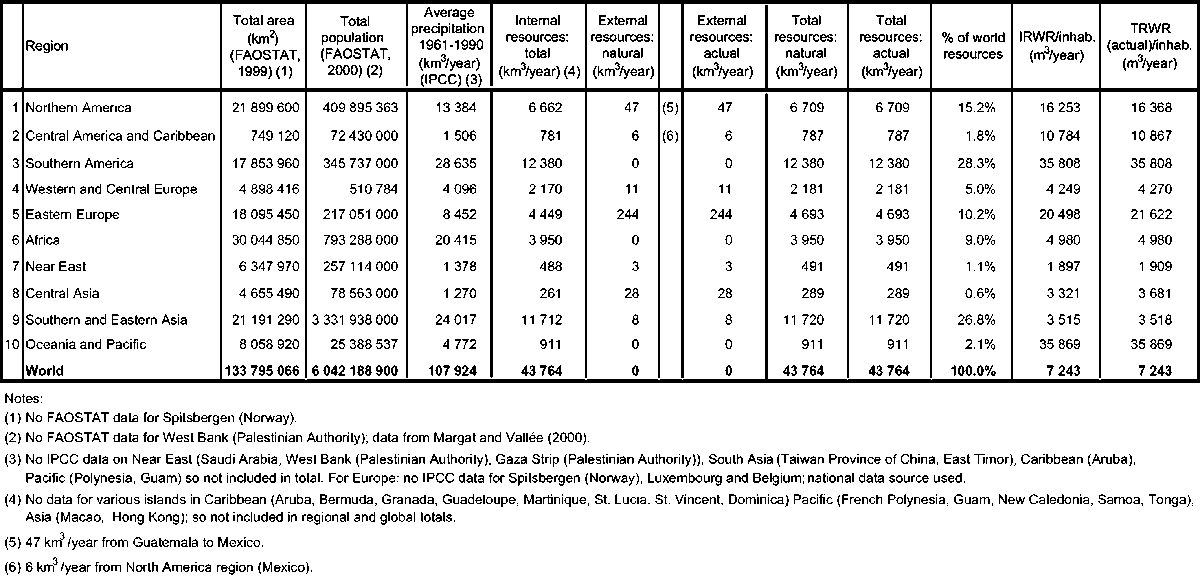
Table 2 presents the results of the global water resources review by region (Annex 3 Map 3). This section comments briefly on the particularities which can be observed on a large scale across the world, as well as difficulties which emerge from the information collected. The table in Annex 2 provides details on individual countries and territories. It presents internal, external and total water resources computed according to the method described in Chapter 3 (differentiating between natural and actual resources). It does not indicate the exploitable resources and the non-renewable resources as figures are available for only a few countries. Figures for water resources per inhabitant are as in 2000.
The total water resources in the world are estimated in the order of 43 750 km3/year, distributed throughout the world according to the patchwork of climates and physiographic structures. At the continental level, America has the largest share of the world’s total freshwater resources with 45 percent, followed by Asia with 28 percent, Europe with 15.5 percent and Africa with 9 percent.
In terms of resources per inhabitant in each continent, America has 24 000 m3/year, Europe 9 300 m3/year, Africa 5 000 m3/year and Asia 3 400.1 m3/year.
At a country level, there is an extreme variability in TRWR: from a minimum of 10 m3/inhabitant in Kuwait to more than 100 000 m3/inhabitant in Canada, Iceland, Gabon and Suriname. For 19 countries or territories, the TRWR per inhabitant are less than 500 m3; and the number of countries or territories with less than 1 000 m3/inhabitant is 29. The ten poorest countries in terms of water resources per inhabitant are Bahrain, Jordan, Kuwait, Libyan Arab Jamahirya, Maldives, Malta, Qatar, Saudi Arabia, United Arab Emirates and Yemen. In the large countries, water resources are also distributed unevenly in relation to the population.
In addition to spatial variability, there is a high variability in time within the year or among different years. This study does not include temporal variability but Shiklomanov (2000) provides estimates on a 67-year data set of the minimum and maximum internal resources for 50 countries.
TABLE 2: World water resources, by region
Variability in dry years is important as it may reduce significantly the rainfall and the volume manageable even in relatively humid areas.
Nine countries are the world giants in terms of internal water resources, accounting for 60 percent of the world’s natural freshwater (Table 3). At the other extreme, the water poor countries are usually the smallest (notably islands) and arid ones (Table 4). The thresholds of 1 000 and 500 m3/inhabitant correspond respectively to the water stress and water scarcity levels proposed by Falkenmark (1986). In an average year, 1 000 m3 of water per inhabitant can be considered as a minimum to sustain life and ensure agricultural production in countries with climates that require irrigation for agriculture.
Thirty-three countries depend on other countries for over 50 percent of their renewable water resources: Argentina, Azerbaijan, Bahrain, Bangladesh, Benin, Bolivia, Botswana, Cambodia, Chad, Congo, Djibouti, Egypt, Eritrea, Gambia, Iraq, Israel, Kuwait, Latvia, Mauritania, Mozambique, Namibia, Netherlands, Niger, Pakistan, Paraguay, Portugal, Republic of Moldova, Romania, Senegal, Somalia, Sudan, Syrian Arab Republic, Turkmenistan, Ukraine, Uruguay, Uzbekistan, Viet Nam and Yugoslavia.
The scarcity and disparity of water resources are exacerbated by differing levels of usability (and therefore mobilization costs) and particularly by environmentally sustainable usability. Water quality also differs. Only a part of natural water resources can be contained and utilized. Basin management is generally recommended but is not common practice; it is unsuitable for arid areas (with no functional basin), large karstic zones and highly fragmented basins.
Scarcity and disparity are intensified by the threat and impact of human activity that disrupts water regimes and leads to a deterioration in water quality, and also by the vulnerable nature of some chronically overutilized resources: salinization of coastal aquifers (e.g. Spain and Israel) and the disappearance of sources (e.g. Tunisia). Moreover, the partitions between numerous countries (the Balkans, the Nile Basin) make the situation more complex.
Therefore, the inequalities among countries in accessing freshwater are amplified when considering the differences in development, treatment and rehabilitation works, as are the related costs required to obtain exploitable natural resources. The effort required varies significantly with the accessibility and regularity of the resources. For example, the ratio of exploitable water resources to total renewable resources is close to 100 percent in areas of the Mediterranean where the main source of water is groundwater (Israel, Gaza Strip (Palestinian Authority) and Libyan Arab Jamahiriya) but generally less than 70 percent in countries where surface water resources are important (Turkey, Morocco, Greece, etc.) and even lower where there are major technical constraints (Malta) or political restrictions (Portugal) (Table 5).
As the data collection was based essentially on a literature review both at a country level and within FAO, the quality of the results is related closely to national data production and reporting systems. The consistency of results at regional level was checked carefully.
TABLE 5: Exploitable resources in Mediterranean countries
TABLE 6: Comparison of water resources data from different sources, the United States of America
The option chosen was to rely on country information. This was based on the assumption that no regional information can be more accurate than studies carried out at country level. However, there are a number of difficulties when dealing with national sources:
In most cases, a critical analysis of the available information is necessary to ensure consistency between the different data collected for a country and a river basin.
Gathering data from different sources highlights similarities between the different sources, contradictions, and errors in data transcription. For example, in Table 6 some references indicate different figures for the United States of America. Such discrepancies could probably be explained by country experts and may be due to different aggregations and accounting methods.
Very little information exists on water resources in humid Africa.
In arid and semi-arid climates, abundant literature exists as water plays an important role in economic development. However, access to information on water resources is sometimes restricted for strategic reasons.
The accuracy and reliability of information vary significantly between regions, countries and types of data. No consistency can be ensured at regional level on the duration and dates of the period of reference.
This section presents some of the difficulties in computing external water resources.
Precipitation is indicated in the country summary tables as a reference but is not used in the data computation. The average volumes for precipitation given by countries are generally estimated from precipitation maps (isohyets). Country values were obtained from country surveys, but the overall reliability of the results was considered low because of the lack of historical data sets or poor geographical coverage of the country. Therefore, the precipitation data used in this study are based on data prepared and published by the Intergovernmental Panel on Climate Change (IPCC) (New et al., 1999; Mitchell et al., 2001). Box 8 provides some examples of existing monitoring systems.
|
BOX 8 - HYDROLOGICAL OBSERVATIONS AND MEASUREMENTS The quality of knowledge in hydrology is dependent on the availability of historical data sets and therefore on the continuity of data collection. Hence, current efforts at observation and investigation are not of immediate use. The collecting of climate data started in the nineteenth century in some countries (Table 8). However, hydrological and hydrogeological measurements are more recent, and sensitive to political change. Therefore, long historical data sets are rare. However, the longest ones concern arid countries where water development has long been important. An indication of the current efforts to produce basic data is evidenced by the statistics on the measurement networks (precipitation and runoff) gathered by the WMO and presented in Table 7 on the Mediterranean countries.
Hydrography networks: widely varying density in Europe (2-8 stations per 1 000 km2) and in the Near East (1-10 stations per 1 000 km2), and lower in Africa. However, these densities are not comparable as the level of knowledge and the hydrography structures differ greatly. |
The following comments stem from an analysis of the surface water resources at river-basin level and by country:
The figures on inflow come from national reports. They may correspond either to actual inflow affected by upstream consumption or to theoretical inflow secured through treaties. Therefore, the actual inflow in certain countries may be different from the inflow secured by treaties indicated in the tables.
Another difficulty related to the inflows or outflows secured by treaties relates to the fact that most treaties establish the exchanges between countries in terms of percentage of basin water resources, whose amount varies from year to year.
For flows not subject to formal treaties or agreements, the values indicated in the tables should correspond to average annual actual flows in recent years. However, owing to data collection difficulties, the flow average was not obtained systematically for the same period. Therefore, the figures should be considered as best possible estimates.
The quality of the estimation of internal surface resources depends on:
i. the density of the hydrometric stations in each country (related to the structure of the hydrography network) and the length of the observation period (Box 8);
ii. the percentage of the territory where the runoff is measured and where it is calculated from modelling using climate data sets.
TABLE 7: Measurement stations in Mediterranean countries

Source: Margat, in preparation
TABLE 8: Observation stations in the world

Source: Shiklomanov, 1997
Depending on the source, the value provided under groundwater resources may indicate either the groundwater recharge or the groundwater productivity.
It is difficult to evaluate the groundwater flow entering or leaving a country. The transboundary groundwater flows are generally very small in comparison with the surface water flows. Therefore, uncertainties about them do not affect the results significantly. This is also generally the case for the groundwater outflow into the sea, except for Lebanon and some small islands such as Malta.
In the case of conflicting sources of information, the difficulty lies in selecting the most reliable one. In some cases, water resources figures vary considerably from one source to another. There may be various reasons for such differences:
Differences in computation methods or definitions used in computing water resources.
Differences in the reference period used to calculate water resources.
Overestimation of resources where there is double counting of surface water and groundwater.
Specific problems of transboundary rivers. Methods used by countries to compute transboundary rivers flows are not always transparent.
Misuse of the concept of renewable water resources. Some sources include extraction of fossil water as part of water resources. Others include secondary sources of water such as wastewater or return flows from agriculture.
Changes in estimates, often upwards, following improvements in knowledge, methods or measurement networks. For example, for three Maghreb countries (Tunisia, Algeria, and Morocco) the average total flow increased by 20 percent in 20 years, from 38 km3/year in 1970 to 48 km3/year in 1990.
Where national data are absent or not reliable, it may be necessary to obtain estimates from models and satellite imagery. However, while modelled data may be useful, they cannot replace local measurements. The sources rarely provide information on the origin of data (meta-data: which data production, monitoring and treatment schemes; when exceptions from the rules were applied; differences in definitions; etc.) and on data processing (how the data were extrapolated, how data-gap situations were solved, etc.).
Because of the global approaches used in all but one of the previous studies mentioned in Chapter 1 (Table 9), comparisons between them and the information collected in this report were possible only at continental or global level.
Prior to analysing the figures, some clarification is necessary. First, this study used the figures proposed by L’vovitch (1974) for 10 out of 53 countries in Africa as no better information was found in recent country reports. These ten countries are located in well-endowed regions, and together they account for about 54 percent of the total water resources of the Africa region. Thus, the comparison with L’vovitch’s figures is relatively biased.
TABLE 9: Major assessments of the world’s natural internal freshwater resources
The figures given by the World Resources Institute were computed using various data sources: FAO (Aquastat), the Institute of Geography of the former Soviet Union, and Shiklomanov (2000). Gleick (1993, 1998 and 2000) provides an exhaustive compilation work and includes data from FAO’s Aquastat programme. These indications may help explain the similar results obtained by these different sources.
It is not the purpose of this comparison to explain differences in results. Computing methods and the assumptions they imply are so different that such an exercise would be of limited value. Rather, this study confirms the relatively good knowledge of the state of the world’s water resources at global and regional scales. This study indicates a world water resources total of 43 764.3 km3/year, between the 42 780 km3/year indicated by Shiklomanov (2000) and the 44 540 km3/year indicated by Gleick (2001). The main differences relate to two regions: Europe and Oceania. For Europe, the main reason relates to accounting for the Russian Federation. The Aquastat programme considers all the Russian Federation to be in the Europe region whereas the other studies included part of it in Asia. The case of Oceania is unclear but probably relates to accounting for the water resources of the islands (the estimates for Australia are the same).
In this study, water resources assessment at country level was based mainly on hydrological information on the main rivers extrapolated to areas where direct measurements were not available. Although all efforts were made to present a standard framework for water resources computation, the methodology used in this study (relying on country information), does not ensure consistency in the water resources assessment methods from one country to another.
In order to overcome this problem and to improve the comparability of the water information at regional and global levels, FAO’s Aquastat programme is also working on the development of global GIS-based data sets and modelling tools.
A water balance model has been developed and implemented on Africa. The results are presented in the CD-ROM “Atlas of water resources and irrigation in Africa” (FAO, 2001). Available information on Africa was processed through a continental GIS-based model to provide a comprehensive picture of the different elements of the water balance at continent scale. This approach makes the best use of scattered information and enables extrapolation of point data or data available at country level to develop a credible picture of the situation of the continent’s water use and its impact on water resources. It also has the advantage of presenting a homogenous methodology for computing the water balance across the continent.
The model used in the Africa study is simple and performed entirely within the GIS environment. It makes the best possible use of available information, be it regional coverage of the main climate elements of the water balance (precipitation and crop water requirements), soil properties, or irrigation. The model consists of two parts. A vertical soil-water balance model, performed monthly for every grid cell (10 km × 10 km), computes the part of precipitation that does not return to the atmosphere through evapotranspiration. This water, termed surplus in the study, is then routed through the landscape in the rivers by the horizontal part of the model. In GIS, this is performed by generating a grid-based hydrological network based on an available digital elevation model.
Crop water requirements were calculated using the modified Penman-Monteith method as described in FAO (1998c). They were calculated for each grid cell on a monthly time step and compared with the actual evapotranspiration, ETa(m), resulting from the soil water balance model. The difference was then multiplied by the cropping intensity to obtain a monthly grid of irrigation water requirements. The model was calibrated as far as possible against measured natural river-flow data.
The precipitation data used for this study are based on data prepared and published by the International Institute for Applied Systems Analysis (IIASA). For each of the stations used in the gridding exercise, data were averaged over a 30-year period from 1961 to 1990.
Data on reference evapotranspiration used for this study had also been prepared by the IIASA for FAO (FAO, 2000). The resolution of this data set is equal to the resolution of the precipitation data set, 0.5 degrees of latitude by 0.5 degrees of longitude, with mean monthly values for global land areas (excluding Antarctica) for the period 1961-1990. The data set was prepared according to the FAO Penman-Monteith method with limited climate data as described in FAO (1998c). The input data used to calculate ETo are part of the CRU Global Climate Dataset prepared by the Climate Research Unit of the University of East Anglia, the United Kingdom, and distributed through the Web site of the IPCC.
The digital data layer with the drainage pattern used for this project was a 1:5 000 000 line coverage with the rivers of Africa (digitized in 1994 for the UNEP/FAO Desertification Assessment and Mapping Project). The coverage with water bodies originates from the Digital Chart of the World 1:1 000 000. The water bodies of Africa have been characterized (as lake, lagoon, reservoir, etc.) and named (where names were readily available). The data layer as used in this project contains all the water bodies that had a name and were not characterized as rivers.
TABLE 10: Comparison of measured and modelled data for African countries
Table 10 compares the IRWR as published by FAO (Aquastat) and presented in this report (table in Annex 2) with the values computed by the model. The calculated values in Table 10 are generally lower than the country-based data. This is especially apparent in the more arid countries. For these countries, the model calculates hardly any runoff while the country statistics indicate some renewable water resources. The water balance model used for this study computes the internally generated water resources (IRWR) by subtracting the total inflow to the country from the total flow accumulation leaving the country, disregarding water leaving the system by evaporation from large lakes and wetlands. In arid areas, this method leads to an underestimation when compared with the results of conventional studies that estimate the water potential through the recharge of groundwater and the river discharge at the points where the runoff is maximum.
Another explanation for the difference with country-based data is that the time-span used for the model is a month. In arid areas, such a long time-span tends to overestimate evaporation, thus reducing the estimate of water resources. It is difficult to assess the reliability of the model’s results for the semi-arid and arid countries (e.g. Egypt, Djibouti, Eritrea, Morocco and Namibia). In other cases, the model may give a higher figure than the national statistics as it assesses resources before local evaporations happen. This is the case for the Libyan Arab Jamahiriya, Algeria and Burkina Faso.
In humid areas, the comparison shows a relatively good concordance between country-based and modelled figures. In some countries of the intertropical humid area (Democratic Republic of Congo, Gambia, Mali, Sierra Leone, Somalia and Uganda), the difference between national statistics and calculated ones is negative. This might indicate a problem in these countries’ estimates of water resources, in particular in the distinction between internal and external water resources.
This modelling exercise shows how it may be necessary to obtain estimates of water resources from models where national data are absent or unreliable. The model is a useful tool for checking the overall results of the study and for pinpointing possible errors. The model was used to cross-check the Africa data sets. Where there were clear inconsistencies, the country water balances were reviewed and modified as necessary. Therefore, the combined use of country-based data and global water-balance modelling can enhance the overall reliability of the results.
This report presents the approach used by FAO to assess natural and actual water resources for the world by country. It deals with renewable freshwater resources and concentrates mainly on the physical assessment of internal and external resources. It presents a picture of the state of the world’s water resources that is not only the natural state but also the current situation, taking into account existing uses of water and their implications for countries sharing common river basins. It is also a first attempt, albeit still an incomplete one, to present estimates of exploitable water resources, i.e. the part of the countries’ water resources that can be put to beneficial use.
The major characteristics of this approach are:
It proposes a comprehensive way to: (i) compute surface water resources and groundwater resources; (ii) avoid double counting; and (iii) assess resources in a transparent manner from available national information.
It is transparent in the way water resources figures are calculated.
It reviews in depth the water exchanges at border level in order to ensure consistency in the results between countries.
It introduces the concept of exploitable resources in order to obtain a more realistic estimate of water resources availability.
It distinguishes clearly between renewable and non-renewable resources.
It enhances the overall quality of country-based data by comparing them to the results of a global water-balance model. It highlights drawbacks and overestimation in existing data sets. Both tools are mutually reinforcing.
There remains much to do in order to obtain sound statistics on water resources, and particularly standardized data sets, at global level. Therefore, the methodology used in this study to compute water resources is intentionally simple and based on transparent rules. However, more effort needs to be focused on the assessment of the variability of water resources in space (watershed level), in time (dry-year resources) and according to constraints (exploitable resources). Desegregated information at river-basin level is particularly important in large countries with very diverse climate conditions (e.g. Russian Federation, Brazil, United States of America, and China). National averages hide local differences and, for large countries, are of little use for assessing the country’s water situation.
The use of global data sets (meteorological, etc.) coupled with water-balance models can contribute to improving the assessment of water resources as shown above for Africa. This experience should be extended to the rest of the world, keeping in mind that the field-based approaches (based on measurements) and the modelling approaches are complementary.
This study bases the country-level estimates of natural renewable water resources mainly on climate and hydrological data sets for the last decades of the twentieth century. They are representative of the average flows of the last 25 to 50 years. These averages are considered to be stable and not affected by change. However, there is no certainty that these averages will remain stable in the long term.
There is no certainty today about the extent, dynamics and regional distribution of climate changes forecast for the twenty-first century. However, the potential impacts on water resources cannot be ignored.
The first world projections on this subject such as those made by the University of Kassel (Alcamo et al. 1999, for the World Water Vision) provide country projections for 2025 and 2075. Although it may be too early to draw a picture of the future of water resources, water development planning must take into account the uncertainty related to the possible impacts of climate change on water resources within the context of growing water demand.
![]()
![]()
![]()