AQUASTAT - FAO's Global Information System on Water and Agriculture
Irrigation water requirement
Precipitation, and in particular its effective portion, provides part of the water crops need to satisfy their transpiration requirements. The soil, acting as a buffer, stores part of the precipitation water and returns it to the crops in times of deficit. In humid climates, this mechanism is sufficient to ensure satisfactory growth in rainfed agriculture. In arid climates or during extended dry seasons, irrigation is necessary to compensate for the evapotranspiration (crop transpiration and soil evaporation) deficit due to insufficient or erratic precipitation. Irrigation consumptive water use is defined as the volume of water needed to compensate for the deficit between potential evapotranspiration on the one side and effective precipitation over the crop growing period and change in soil moisture content on the other side. It varies considerably with climatic conditions, seasons, crops and soil types. For a given month, the crop water balance can be expressed as follows:
ICU = ETc - P - DS
with: ICU = irrigation consumptive water use needed to satisfy crop water demand (mm)
ETc = potential crop evapotranspiration (mm)
P = effective precipitation (mm)
DS = change in soil moisture (mm)
In this study, the irrigation consumptive water use is computed for each country on the basis of the irrigated crop calendar for a specific year, as the difference between the crop water requirement—i.e. the potential evapotranspiration of AHIfull — and the water balance under natural conditions — i.e. actual evapotranspiration (ETa) under non-irrigated conditions. In the specific case of paddy rice, additional water is needed for flooding to facilitate land preparation and for plant protection. This additional amount is calculated by multiplying the harvested area under irrigated rice by a water layer of 20 centimetres. In that case, the irrigation water requirement is the sum of rainfall deficit and the water needed to flood paddy fields. Otherwise, it is equal to the irrigation consumptive water use.
The irrigation water requirement computed in this study is available by country under the variable "Irrigation water requirement" [code 4260] in the AQUASTAT Country Statistics. It also appears by country in (Table 4) and by region in (Table 5), comparing irrigation water withdrawal and irrigation water requirement.
Calculation methods of the two components of the irrigation water requirement equation are detailed below.
Water balance under non-irrigated (or natural) conditions
Renewable water resources corresponds to the sum of internal renewable water resources—surface water and groundwater resources produced internally—and external renewable water resources—surface water and groundwater resources entering and bordering the countries minus those leaving the country if secured by treaties or agreements for a downstream country. The internal component originates from the part of endogenous precipitation flowing into rivers and lakes or infiltrating into aquifers after evapotranspiration of natural ecosystems, including grass and trees. Thus the annual water balance in natural conditions, i.e. without irrigation—also understood as the maximum theoretical yearly amount of water actually available for a given area—, can be calculated as the sum of the annual precipitation and the balance of external renewable water resources minus evapotranspiration (excluding evapotranspiration caused by groundwater and surface water flows towards open water bodies and wetlands). One of the activities undertaken by AQUASTAT is to compile information on renewable water resources by country and based on this make its best estimates of the main elements of the water balance for each country.
The global water balance has spatially distributed input layers—derived as much as possible from the public domain—and consisting of datasets for precipitation, reference evapotranspiration, and soil moisture storage properties:
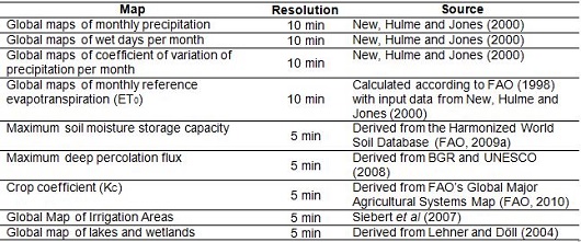
The computation of the water balance is carried out on a spatial resolution of 5 arc degree grid-cells and in daily time steps. The results of the water balance calculations consist of monthly values by grid-cell for generated long-term average precipitation, actual evapotranspiration, incremental evapotranspiration caused by irrigated agriculture, surface runoff, groundwater recharge and water stored as soil moisture. Summarized annual water balances can be calculated for any desired spatial domain (for example countries or river basins) and include, apart from the above mentioned variables, incremental evapotranspiration over open water and incremental evapotranspiration over wetlands.
For each grid cell, potential crop evapotranspiration (ETc) is calculated on a daily basis according to the methodology described in FAO Irrigation and Drainage paper 56 (FAO, 1998):
ETc(t) = Kc x ETo(t)
with: t = time step (days)
ETc(t) = potential crop evapotranspiration on t (mm)
ETo(t) = reference evapotranspiration on t (mm)
Kc = crop or land use factor (-)
The crop or land use factor Kc varies during the growing season depending on the growing stage. However, for rainfed conditions it was decided not to apply differentiated Kc factors, since no distinction was made between the different crops grown on rainfed agricultural land. Actual evapotranspiration (ETa) under non-irrigated conditions is assumed to be equal to the potential crop evapotranspiration (ETc), in those periods of the year when precipitation exceeds potential evapotranspiration or when there is enough water stored in the soil to allow maximum evapotranspiration. In drier periods of the year, when the available soil moisture is reduced below a certain level, lack of water reduces actual evapotranspiration to an extent depending on the available soil moisture.
Evaporation and evapotranspiration in open water areas and over swamps and wetlands is assumed to be 10 percent higher than reference evapotranspiration throughout the whole calculation period.
For each grid cell, the available soil moisture is calculated per day by adding in- and outgoing fluxes to the available soil moisture of the day before. Runoff occurs when the balance of the in- and outgoing fluxes exceed the maximum soil moisture storage capacity, and thus is calculated as the part of the precipitation that does not evaporate and cannot be stored in the soil. Runoff is always positive except for areas identified as open water or wetland, where actual evapotranspiration can exceed precipitation. Groundwater recharge is assumed to occur only above a certain level when there is enough water available in the soil to percolate.
The model is calibrated by comparing calculated values for water resources per country (i.e. the difference between precipitation and evapotranspiration) with data on internal renewable water resources for each country obtained from AQUASTAT country surveys and presented in the country water resources sheets. Where differences between calculated values and AQUASTAT country statistics were considered too big, correction factors have been applied to soil moisture storage capacity parameters and maximum recharge fluxes.
The model was validated by comparing the discharges of major rivers given in the Global river discharge database (SAGE, 2012) with the calculated runoff for the drainage basins of these rivers.
This calibrated and validated spatial water balance is used for the computation of the crop water requirement (below) and the irrigation water requirements.
Crop water requirement
The calibrated water balance under natural conditions, the Global map of irrigation areas (version 4.0.1; Siebert et al., 2007 and 2010) and the irrigated crop calendars are used as inputs for the computation of the crop water requirement, that is the potential evapotranspiration of irrigated crops. Like the computation of the water balance under natural conditions, the calculation of the potential crop evapotranspiration is carried out on a spatial resolution of 5 arc degree grid-cells and in daily time steps and can be presented in statistical tables or maps at different levels of spatial aggregation.
The evapotranspiration of a crop under irrigation (ETc in mm) is obtained by multiplying the reference evapotranspiration (ETo) with a crop and growing stage specific coefficient (ETc = Kc x ETo). This coefficient has been derived for four different growing stages: the initial phase (just after sowing), the development phase, the mid-phase and the late phase (when the crop is ripening to be harvested) (FAO, 1998). In general, these coefficients are low during the initial phase, after which they increase during the development phase to high values in the mid-phase and again lower in the late phase. It is assumed that the initial phase, the development phase and the late phase each take one month for each crop, while the duration of the mid-phase varies according to the type of crop. For example, the growing season for wheat in Bangladesh, displayed in the example of irrigated crop calendar, starts in December and ends in April, as follows: initial phase: December (Kc = 0.4), development phase: January (Kc = 0.8), mid-phase: February - March (Kc = 1.15), and late phase: April (Kc = 0.3). The crop coefficients for the different crops and growing stages are presented in Annex 1. It is assumed that there is always enough water available to assure that crops under irrigation never suffer water stress.
The rate of evapotranspiration coming from the irrigated area per month and per grid cell is calculated by multiplying the area equipped for irrigation with cropping intensity and crop evapotranspiration for each crop.
ETc(t) = IA x Σc( CIc x Kc x ETo(t) )
with: t = time step (days)
ETc(t) = evapotranspiration of an irrigated cell on t (mm)
IA = area actually irrigated as percentage of cell area for the given grid cell (ha)
c = crop under irrigation
Σc = sum of the different crops
CIc = cropping intensity for crop c (-)
Kc = crop coefficient, varying for each crop and each growth stage (-)
ETo = reference evapotranspiration (mm)
The difference between the calculated evapotranspiration of the irrigated area, ETc, and actual evapotranspiration under non-irrigated conditions, ETa, is equal to the incremental evapotranspiration due to irrigation, also called the irrigation consumptive water use (ICU):
ICU(t) = ETc(t) - ETa(t)
The amount of irrigation consumptive water use is computed for each country and for a specific year. In addition, in the case of flood paddy fields, an additional amount of water (20 cm) for land preparation and flooding for plant protection is added to this rainfall deficit for the calculation of the irrigation water requirement.
IWR = ( ICU(yr) x Acell + 0.2 x Apaddy(yr) ) x 10
with: IWR = total irrigation water requirements per year (m3)
ICU(yr) = irrigation consumptive water use per year (mm)
Acell = area of the grid cell (ha)
Apaddy(yr) = area under paddy irrigation per year (ha)
This extra water for paddy fields will be mostly returned to rivers or underlying aquifers and thus is not part of the irrigation consumptive water use. The element of irrigation water requirement dedicated to salt leaching is not estimated and thus not included in estimations proposed in this study due to lacking data regarding salinization which is highly contextual. The calculated irrigation water requirement corresponds to net irrigation water requirement, which does not include water lost in delivery (conveyance, distribution, application).
Resulting irrigation water requirements, after corrections when necessary, are available by country under the variable "Irrigation water requirement" [code 4260] in the AQUASTAT core database. Based on these irrigation water requirements, irrigation water withdrawals (3rd step) are estimated for countries where this data is unavailable. Estimations of both irrigation water requirement and irrigation water withdrawal are compared in synthesizing Table 4 by country or Table 5 by region.


