AQUASTAT - FAO's Global Information System on Water and Agriculture
WaPOR - Using Remote Sensing in support of solutions to reduce water productivity gaps
![]()
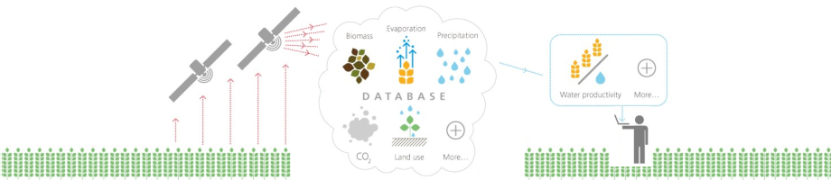
FAO has developed, with the support of the government of the Netherlands, an open access, near real time database using satellite data. The geospatial layers provided allow the monitoring of water productivity and a wide range of applications that can benefit stakeholders from farmers to basin managers, to policy-makers, contributing to a better and more informed use of water resources and a sustainable increase in agricultural production.
In its second phase now since January 2021, for a period of 5 years, the project will continue providing data with an expanded coverage and will respond to the growing demand for practical applications by operating in 10 countries where the project components will be executed.
Project components
The activities of WaPOR phase 2 center around 3 components:
- the spatial database which is a continuation of the current one containing a variety of layers such as water productivity, biomass production, evapotranspiration, land cover classification, among others that are available in different spatial and temporal resolutions. Currently covering Africa and the Near East, the database will expand towards global coverage.
- capacity development that aims at training different stakeholders to the utilisation of the database for practical field and policy applications.
- a compendium of implementable solutions and tools using WaPOR data that are co-developed with different stakeholders with a user-centered approach that lead to actual improvements in land and water productivity.
Find out more about WaPOR data by watching this short video, reading the project flyer and by exploring the WaPOR website as well as the WaPOR portal.
WaPOR data can also be accessed through the AQUAMAPS portal, AQUASTAT’s online geospatial database on water and agriculture.
To learn more about the uses of WaPOR data, browse through the WaPOR applications catalogue.


