FRA 2000 country reporting process
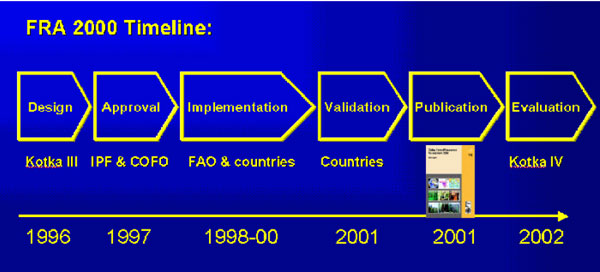
FRA 2000 was produced during the period 1996-2002 and includes all countries and territories. The assessment followed a strategic plan based on the recommendations of a 1996 expert consultation (Kotka III). The plan was formally endorsed by the FAO Committee on Forestry (COFO) in 1997. The data compilation was carried out from 1998-2000. In 2001, national authorities validated the data and the results were then published on the FAO Web site and as the FRA 2000 Main Report (FAO Forestry paper 140). The final phase of the FRA 2000 process was the Kotka IV expert consultation review in July 2002.
FRA 2000 involved data compilation at the national, regional and global level as described below.
- National level. FRA 2000 describes the state of the world’s forest up to the year 2000 and employs a homogenous set of definitions for all countries and territories. The FRA 2000 national level area data were based on existing documented forest inventory data and were compiled in cooperation with and validated by the national authorities. Data from these compilations are available as country profiles or in a summarized format via the FRA 2000 global tables.
- Regional level. FRA 2000 includes a remote-sensing survey that covers about 10 percent of the forest area in the tropical zone. The remote-sensing survey interprets land use at three points in time (around 1980, 1990 and 2000), allowing for studies of forest cover change processes in the tropics during the two decades 1980-2000. For the three tropical regions, the survey provides regional estimates of forest area and land use changes. These estimates are independent of the national assessments of forest resources based on country submissions.
- Global level. New global maps of forest cover and ecological zones were produced for FRA 2000 by using low-resolution satellite imagery. The global mapping was not used to estimate forest area and forest area change but to supplement the core information related to conventional forest inventories, which were based on country submissions, to produce estimates of the proportional distribution of forests by ecological zone.
FRA 2000 used the following approaches:
- full participation by countries in the collection, analysis and validation of data;
- capacity building at the national, subregional and regional levels;
- a remote sensing survey of forest resources in tropical countries;
- global mapping of forest cover and ecological zones;
- development of an integrated forest information system;
- participation of internationally recognized experts in all phases;
- partnerships with leading international institutions;
- comprehensive worldwide information dissemination using print media and the internet.
FAO-Rome compiled the FRA 2000 data for the developing countries while the UN-ECE in Geneva compiled the data for the industrialized countries. The global findings of FRA 2000 were published in 2001 in FAO Forestry Paper 140 FRA 2000 Main Report.
For temperate and boreal forests, detailed information is provided in the 2000 Geneva Timber and Forest Study Paper No. 17, by UN-ECE, Geneva. Main Report - Forest Resources of Europe, CIS, North America, Australia, Japan and New Zealand.
Kotka III
- Kotka III