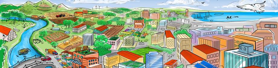
Kigali, Rwanda
Background
Kigali has population of 1,132,686 (2015), and hosts more than 50 percent of urban population in Rwanda. Its urban growth rate is three percent. More than 50 percent of the population under 25 years old.
The city region food system (CRFS) of Kigali
In its preliminary definition, the city region of Kigali has been defined using two criteria:
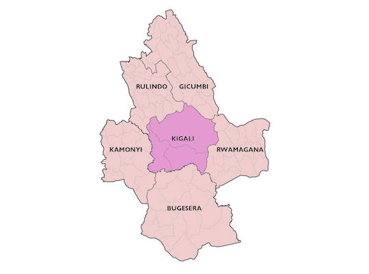
- The administrative boundaries: The city region is defined by the administrative boundaries of the districts that are part of the city of Kigali as well as the neighbouring districts of Kamonyi, Rulindo, Bugesera, Rwamagana and Gicumbi.
- The food flows: Neighbouring districts have been selected based on food flows between them and the city of Kigali as most food consumed in the city region comes from these districts.
The boundaries will be further refined following the assessment of the city region food system (CRFS) project.
Key food commodities
The Rwandan diet is based primarily on starchy foods and vegetables. In particular, the common diet consists of roots and tubers (Irish potato, sweet potato, cassava), fruits (plantains), legumes (bean and soybean), vegetables (cabbage, spinach, amaranth), and oil. High value products, such as, meat, dairy products and other fruits (oranges, pineapples, papaya, mango, avocado, banana, passion fruits and tree tomato), are consumed less frequently-only once or twice a week.
Generally, banana, Irish and sweet potato, cassava, vegetables and beans make up the most important source of daily consumed calories across the entire Kigali city region.
Main climate shocks and stresses affecting the CRFS
Main climate hazards (shocks and stresses)
The climate shocks and stresses identified for the CRFS of Kigali differ locally, however, there is a clear trend showing an increasing occurrence of climate extreme events over time and in various regions of the country, including the districts mainly responsible for feeding the city region of Kigali.
According to the country’s INDCs from 2015 (Republic of Rwanda, 2015), seasonal shortages of food are caused mainly by prolonged droughts and heavy rain events resulting in floods and soil erosion. This has also been confirmed by a study that created an inventory of the most current environmental risks due to climate change (Ministry of Foreign Affairs of the Netherlands, 2018). According to this inventory, droughts and floods are issues that are evident regionally. Primarily, droughts impact the eastern part of the Kigali city region and floods impact the western, northern and southern parts. Recently, Rwanda has also submitted its updated NDCs, confirming that the country is facing consequential impacts of climate change (Republic of Rwanda, 2020).
Floods and heavy rain events
Heavy rainfalls associated with storms severely affect many districts in the eastern province, including Rwamagana and Bugesera often leading to damaged buildings and crop losses (MIDIMAR, 2015). Heavy rain events are also partially responsible for landslides, impacting large parts of the population in the highlands of the western, southern and northern provinces of Rwanda.
Further analysis has shown that flooding events in the CRFS of Kigali occur particularly along the Nyabarongo river in the riparian districts of Nyarugenge, Rulindo, Bugesera and Kamonyi.
Windstorms
Storms affect mostly the eastern parts of the CRFS of Kigali, mainly the district of Rwamagana. According to a MIDIMAR assessment report (MIDIMAR, 2015), storms associated with heavy rains have destroyed many houses and schools of the lower land areas of Eastern and Southern Districts including Rwamagana (Nyasimi, Radeny and Hansen, 2016).
Droughts
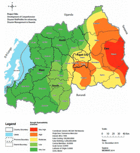
According to the National Risk Atlas of Rwanda and as expressed in the map below, the CRFS of Kigali is mainly affected by droughts from March to July (season B). In 2015, during season B, districts in the city of Kigali were heavily impacted by severe droughts, specifically the districts of Gasabo (50 ha impacted), Kicukiro (1,880 ha), Nyarugenge (1,010 ha), Bugesera (14,940 ha), Rwamagana (16,800 ha), and the district of Kamonyi (860 ha) in the southern province.
Changing rainfall patterns and temperature increase
According to the Third National Communication of Rwanda under the UNFCCC (Republic of Rwanda, 2018), rainfall has become increasingly intense and the variability is predicted to increase by five to ten percent.
For the south-west and eastern regions of Rwanda, there has been an observed trend in rising temperatures from 1971 to 2016 with an increase in mean temperatures from 1.4°C to 2.56°C-contributing to climate change impacts on the agriculture and CRFS of Kigali. Overall, predictions foresee a rise in temperature for the coming decades until 2050, especially during the dry season, thus increasing the probability of prolonged drought events (Republic of Rwanda, 2018).
Impacts of climate shocks and stresses on the CRFS
The impacts of climate hazards on the CRFS of Kigali, related livelihoods, ecosystems and infrastructures vary depending on season and key commodity/area. Overall, hazards with main impacts on the food system in the city region of Kigali have been identified as droughts, floods, windstorms and landslides caused by heavy rain events (Republic of Rwanda, 2018). Findings show that the CRFS food system is mostly affected by hazards in the food production and transportation sector.
It should be noted that socio-economic factors such as building in flood-prone areas, population growth and related high population density in hazard-exposed areas, the construction of key food-system related infrastructure in flood-prone areas and poor land-use management are additional factors that have an influence on the climate vulnerability of the CRFS of Kigali (Republic of Rwanda, 2018).
Food production
90 percent of crops are grown on steep slopes across most parts of Rwanda, increased heavy rainfall events exacerbate soil erosion and further contribute to the degradation of cultivated land (USAID, 2019). Mainly dependent on rain-fed agriculture, production systems in the CRFS of Kigali are highly vulnerable to climate impacts. Floods with adverse impacts on crop production were recorded in Kamonyi and Kicukiro districts of the Kigali city region region (Rwanyiziri et al., 2019). Additionally, the change in rainfall patterns in the Bugesera district has negatively affected the production of rice and altered the hydrological cycle and water sources (Rwanyiziri and Rugema, 2013). It has also been observed that with increasing temperatures, crop pests and diseases are likely to be a threat to crop production. While bean and maize yields are projected to decrease under a warming climate (east and south-west areas), temperature increases are likely to expand production potential for maize, Irish potato, cassava, and sorghum until 2050 (USAID, 2019).
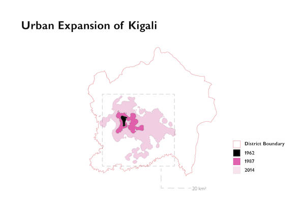
In Kigali city, due to the above-mentioned hazards, cropland has found to degrade or recede fully due to the expansion of urban areas that increased from 2.13 km2 to 100.17 km2 between 1984 and 2016. This has not only led to the loss of fertile production areas in the proximity of the city but also to the loss of valuable ecosystem services (Mugiraneza, Nascetti and Ban, 2019).
Food transport and distribution
Heavy rains causing landslides, floods in marshlands and soil erosion are a major problem for food transport across the city region and regularly responsible for the destruction or obstruction of food system-related infrastructure such as roads or markets. According to a study undertaken by MIDIMAR (MIDIMAR, 2015), the roads affected by landslides were estimated at 2 003 kilometres in 2015. This represented about 74 percent of district roads.
Nyabugogo market, the main wholesale market for fresh produce for the Kigali city region is part of an underdeveloped, fragmented, and unsustainable wholesale system that is regularly affected by climate impacts (Karisimbi, 2020).
Impact on ecosystems
Rwanda is home to mountains, forests, savannah, lakes (especially in Bugesera and Rwamagana district), and wetland ecosystems providing critical ecosystem services such as freshwater supply for the region’s settlements and cultivation. It is situated in the upper reaches of the White Nile and Congo river basins, with abundant lakes, rivers, wetlands, and groundwater resources. These relatively abundant resources face increased pressure from a changing climate. In particular, the central, eastern and northern parts of the Kigali CRFS are more prone to water scarcity (MINIRENA-RNRA, 2015). Warming temperatures and longer dry spells diminish surface flows and reduce groundwater recharge, leading to water shortages. Longer dry periods in the east (e.g. Bugesera, Mayaga, and Umutara regions) and increased heavy rainfall events have an increased influence on species habitat degradation.
The impacts of COVID-19
Farmers, buyers, sellers, distributors, processors and consumers were all severely affected by the restrictions of movement during the COVID-19 lockdown.
Due to the circumstances, farmers were obliged to sell at a very low price and/or discard their products when faced with diminished access to market channels, leading to high levels of food losses. This was especially the case for eggs, milk, maize, fruits and vegetables producers.
Processing industries for foods and animal feeds have dealt with raw material scarcity as many industries operated at minimum capacity during the lockdown period.
To cope with challenges of the pandemic, the government has instituted support to farmers by subsidizing irrigation facilities, inputs and insurance for crops and livestock. In addition to this, the government has decided to support chicken rearing farmers by procuring eggs and distributing them to nutritionally vulnerable children — as well as other food products to households in need.
Priorities for action
In the preliminary phases of the project, a set of priorities has been identified by the stakeholders in order to increase the climate resilience of the Kigali city region food system:
- Inputs and services: increase access to agriculture inputs such as improved seeds, fertilizers and pesticides, financial services to engage into business-oriented agriculture as well as extension service and an operational farmers’ cooperatives forum to allow the farmers to increase production and gain easier access to different services.
- Agriculture water management: build capacities and improve access to infrastructure (irrigation, rainwater harvesting, soil-water management to protect soil against erosion) especially during the dry season in drought prone areas as well as land preparation in marshlands for protection against flooding.
- Climate risk proof infrastructure: promote use and adoption of infrastructure to reduce food losses (e.g. flood proof storage and market infrastructures, etc.).
This set of priorities will be further refined to orient the conduct of an in-depth assessment in the next stages of the CRFS project.
Know more
Factsheet |
|---|
|
