Assessments, tools, indicators and monitoring
 The Global Environment Facility, FAO and the United Nations Environment Programme supported the LADA project with the aim of improving the ability to diagnose land degradation and its impacts. In partnership with the World Overview of Conservation Approaches and Technologies (WOCAT), the project developed a methodology for mapping land degradation and SLM and tested it in six pilot countries – Argentina, China, Cuba, Senegal, South Africa and Tunisia.
The following five LADA manuals provide guidance for the implementation of the LADA process at the various levels:
| |
| |
| |
The local level participatory socio-economic studies allowing to understand drivers and pressures in local areas (watershed, catchment), associated with a more detailed assessment of LD and SLM, LADA Local: | |
| Part 1 - Planning and Methodological Approach, Analysis and Reporting |
| |


LADA assessment tools have been applied in other projects, such as EU-DESIRE and EU-CASCADE.
A manual was developed for conducting local-level land degradation and SLM assessment, including tools for participatory rural appraisal and the analysis of livelihoods, costs and benefits, and impacts.
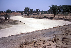
LADA defines land degradation as “a reduction in the capacity of the land to provide ecosystem goods and services over a period of time for its beneficiaries”. The change in condition of one or more ecosystem service will affect land users.
LADA used the “driving force – pressure – state – impact – response” (DPSIR) framework (see figure) to describe the interaction of society and the environment; the framework has been used in more than 25 countries to analyse land status and trends at the local and national levels using both scientific and expert knowledge.
 Under the DPSIR framework, driving forces exert pressures on the environment, and these pressures can induce changes in the environment’s state or condition. The subsequent impacts on socio-economic and biophysical attributes cause society to respond by developing or modifying environmental and economic policies and programmes aimed at preventing, minimizing or mitigating pressures and driving forces.
LADA has produced national-level assessments and maps, and local-level assessments in selected areas, in each of the six pilot countries. The tools, methods and results have been shared through regional and national workshops designed to raise awareness and develop recommendations for policy and institutional arrangements to address land degradation. FAO and the Centre for Development and Environment at the University of Bern has conducted training, and these institutions also host the WOCAT Secretariat to promote the use of tools and methods in Africa, Asia, the Caribbean and the Near East. Several countries – Afghanistan, Bhutan, Burundi, Grenada, Kazakhstan, Kyrgyzstan, Morocco, Nepal, the Philippines, Rwanda, Sri Lanka, Tajikistan, Thailand, Turkmenistan, Uganda, the United Republic of Tanzania and Yemen – are now using the tools, to varying extents.
The LADA project has produced two global products. GLADA (Global Land Degradation Assessment and Improvement), developed by ISRIC, used remote sensing data to identify areas that are becoming degraded and areas where degradation has been arrested or reversed. The study was based on an analysis of vegetation greenness, which used the Normalized Difference Vegetation Index as a proxy for net primary productivity, adjusted for climate change effects on biomass using rain-use and energy-use efficiency. According to GLADA, 22 percent of agricultural land became degraded between 1981 and 2006.7
The second global product from the LADA project is the innovative Global Land Degradation Information System (GLADIS), which shows that more than 30 percent of the global land area, and an even larger area of the inhabitable or productive land area, is subject to significant degradation processes (i.e. strongly or moderately degraded and degrading).
As expected, drylands are most prone to land degradation as a result of vegetation degradation and reduced land cover, but humid areas – especially rainforests – are also fragile environments and prone to rapid degradation if not well managed. GLADIS confirmed the positive correlation between poverty and land degradation (for example, there are more poor people in degraded areas than in areas with stable or improving land resources). This should not be interpreted as meaning that poor people are the key causes of natural resource degradation, however; rather, a widespread improvement in the status of land and ecosystem services would contribute to improving the livelihoods of rural people who depend on those resources. Overall, impact assessments show that investments in SLM provide substantial benefits in terms of human well-being and livelihoods. Such investments are important for restoring and maintaining ecosystem services and increasing the resilience of people and ecosystems to change, shocks and extreme events.
All the methodological information produced by LADA, including workshop outcomes, publications, web-based information systems and the increased expertise of involved national and international organizations, are available to interested parties.
Moving towards comprehensive land assessment approaches
A stocktake of local-level LADA assessments conducted recently by FAO indicates that, in many cases, farmers have been slow to adopt SLM technologies. It is important, therefore, to understand the enabling environment, support, investments, techniques and technologies needed to increase adoption in a given set of biophysical and socio-economic conditions.
Comprehensive land assessments should promote holistic processes that generate the best technical options suitable for specific conditions, enhance the socio-economic enabling environment, manage barriers to change, and support policies and institutions that will ensure successful scaling up.
A common question is: for a certain set of biophysical and socio-economic conditions, what optimal technologies or practices can farmers and other land users introduce to restore degraded land or prevent degradation? Reliable information is required to answer this question effectively, and sources of such information include: WOCAT and Technologies and Practices for Small Agricultural Producers (TECA).
Similarity analyses are used to match areas of interest with areas where farmers have tested, fine-tuned and implemented SLM technologies and where water and land management packages might be applied. Professionals, planners and decision-makers can use the information and products generated from these analyses to identify the most suitable SLM practices and technologies for the targeted areas and communities.