AQUASTAT - FAO's Global Information System on Water and Agriculture
Myanmar
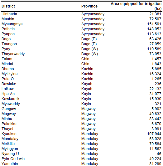
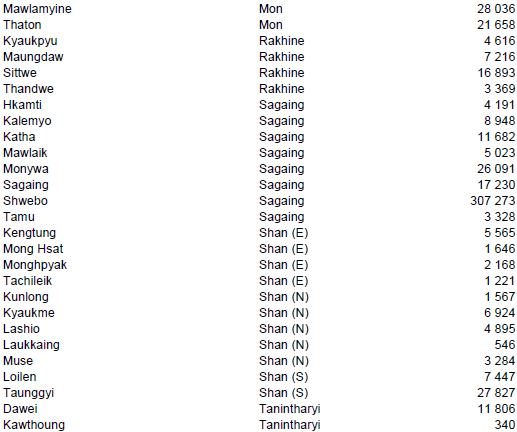
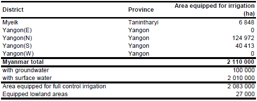
The irrigated area in Myanmar increased from about 1 000 000 ha in the 1991–92 cropping season to 1 841 320 ha in the 1999–2000 cropping season and to 2 110 000 ha in year 2004 [MM01]. Area equipped for irrigation in each of the 63 districts was extracted from the Digital Agricultural Atlas of Myanmar which contained statistical information for the cropping season 2001/2002 [MM02]. Area equipped for irrigation derived from the digital atlas (1 888 141 ha in total) was scaled for each district using the same scaling coefficient so that total area equipped for irrigation was 2 110 000 ha as reported for year 2004. The irrigated area per district estimated that way is visible in the table below and also can be downloaded as Myanmar irrigation areas in PDF or Myanmar irrigation areas in Excel.
The location of 135 major irrigation works (dams, weirs and tanks) was digitized using three maps showing irrigation works constructed in the periods before independence, between 1969 and 1988, and post-1988 [MM03]. However, many projects are large and the irrigated fields may be located far from the major reservoir or weir belonging to the project. Therefore, area classified as irrigated cropland or as rainfed cropland was extracted from the Globcover regional land cover product for Central Asia [MM04]. Irrigated area was first assigned to small scale projects (< 4000 ha) identified according to the three irrigation maps, then to areas classified as irrigated cropland according to Globcover and finally, if required, to areas classified by Globcover as rainfed cropland.
Area equipped for irrigation with groundwater was 55 175 ha in year 1995 [MM05] and increased to 81 000 ha in year 2000 and 100 000 ha in year 2003 [MM01]. The large harvested area of irrigated crops (2 722 000 ha in year 2006) indicates a high cropping intensity on irrigated land [MM05]. It was therefore assumed that the whole area equipped for irrigation is actually being used.
References
[MM01]: Ministry of Agriculture and Irrigation. 2013. Irrigation & crop area. http://id.moai.gov.mm/ website/croparea/areasandmultiplecropping.html, 06/03/2013.
[MM02]: FAO, UNDP, MOAI. 2009. Digital Agricultural Atlas of the Union of Myanmar. http://dwms.fao.org/atlases/myanmar/content\_en.htm, 06/03/2013.
[MM03]: Ministry of Agriculture and Irrigation. 2013. Irrigation works in Myanmar. http://id.moai.gov.mm/website/works/historyofmyanmarirrigationwork.html, 06/03/2013.
[MM04]: ESA. 2008. Regional Globcover Land Cover – Central Asia. Version 2.2. http://postel.mediasfrance.org/en/DOWNLOAD/, 24/03/2009.
[MM05]: FAO. 2013. AQUASTAT Country Statistics.
[MM06]: FAO. 2013. AQUASTAT country profile of Myanmar, version 2011. FAO, Rome, Italy.


