Legacy Soil Maps and Soils Databases
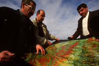
- Comparing a satellite map with the situation on the ground, Republic of Azerbaijan

Legacy maps and databases refer to data and maps compiled using field surveys backed up by remote sensing and other environmental data, expert opinion and laboratory analysis. The bulk of soil information was collected in this way. The technological advances in remote sensing, computers, terrain analysis, geostatistics, GIS data integration, and instrumentation has made it possible to achieve unprecedented reliability and utility in digital soil maps. There is an increasing amount of digital data available on the Internet or as large datasets on CD-ROM, from straight digital conversions of paper maps and databases to direct-to-digital products. Unfortunately, there is also a lot of digital data that is not easily or freely available.

World soil resources (high definition map)

Soil Map of Argentina

Jebel Marra Project Area - Darfur province, Republic of Sudan (high definition map)