5.0 Introduction
Height differences in fish culture
5.0 Introduction |
||
Height differences in fish culture |
||
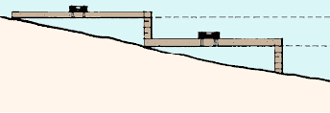
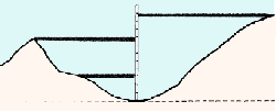
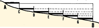
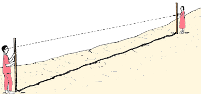
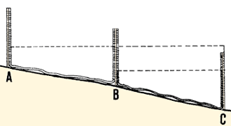
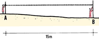
| 1 . In fish culture, you must often measure the difference in height between two points. To construct a pond, you need to determine the heights of the dikes you will build, and the depths of the pond bottoms you will dig. To choose the routes of water-supply canals from the source to the ponds, you will also need height and depth measurements. And when you plan a reservoir, you will also need to make height measurements to determine where its shoreline will be (see Volume 4, Water, Section 4.2). |
|
|
Types of problems you will be facing |
||
| 1. There are three types of problems in the measurement
of height differences.
2. You may have to measure any differences in height among a series of points on the ground, and compare them. From the results of this comparison, you can calculate the heights of given points so that you can make a map (see Chapter 9). This is called surveying the levels of the points, or levelling (see Sections 5.1- 5.9). |
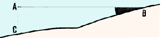
Calculating height differences
 |
|
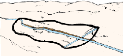
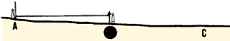
| 3. You may have to locate points which are at the same height. This is called laying out contour lines, or contouring (see Sections 6.2-6.8). |
A contour line
 |
|
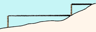
| 4. You may have to locate points which have a given difference in height. In this case, you will be setting out lines of slope with a definite gradient (see Section 6.9). |
Setting out a slope
 |
|
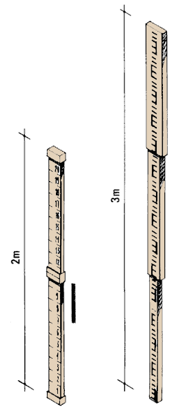
Making your own levelling staff |
||||
|
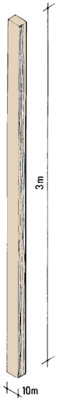
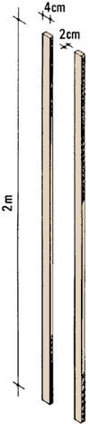
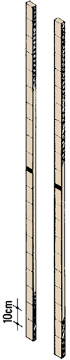
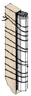
9. To make your own levelling staff, get a straight length of wood, 2 to 3 m long and 5 to 10 cm wide. Clearly mark graduations along it every 10 cm. It is best if you paint the levelling staff white and mark the graduations on it in red. Make these graduations fairly large (about 1 cm thick) so you will be able to read them easily and accurately from a long distance. 10. You can also make a levelling staff by gluing one or more graduated measuring tapes onto a straight piece of wood 2 to 3 m long. Glue the tapes on lengthwise, end to end. To read the small graduations accurately, you may have to decrease the distances over which you take the measurements, or rely on an assistant to make the reading. 11. Another model of levelling staff is described in Section 6.5. It is used for contouring and for setting graded lines of slope. |
 |
Mark the graduations...
 |
... or use measuring tapes
 |
|
Choosing the best method for measuring height differences |
||
| 12. There are a number of good ways to measure height differences. The method of measurement you use will depend on several factors. Each method is discussed in the following sections. Table 7 will also help you to compare the methods and select the one best suited to your needs. Additional information on how to plan your levelling survey, how to record the measurements and how to calculate the results will be given in Chapters 7 and 8. |
Line level
 |
|
|
Theodolite
 |
Improved T-bone level
 |
|
|
TABLE 7
|
|
SIGHTING LEVELS
1
See also Table 8 for contouring and slope setting |
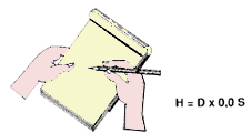
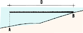
13. If you know the average slope between two points (see Chapter 4), you can easily calculate the height difference between them. First measure the horizontal distance D in metres between points A and B (see Chapter 2). To calculate the height difference H (in metres), multiply D by the slope S expressed in hundredths:
|
H = D x 0.0S |
Example
|
Measure the horizontal distance...
 |
... and the slope...
 |
|
|
to calculate the height |
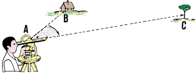
Calculating height differences from vertical angles |
||||
|
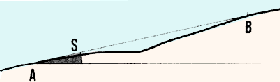
14. If you have measured vertical angle ABC in degrees, you can calculate the height difference AC from:
Example
|
 |
|||
 |
||||
|
With the ground distance, calculate AC = BA x sine
ABC |
||||
 |
||||
|
With the horizontal distance,
calculate AC = BA x tangent ABC  |
||||
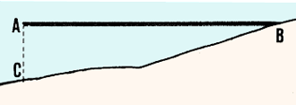
Using height differences to calculate horizontal distances |
||
| 15. You learned earlier that, on sloping ground, you need to correct distance measurements taken along the ground in order to find the horizontal distances (see Section 2.6). |
Ground distance
 |
|
|
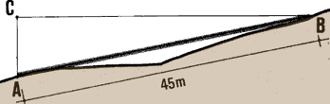
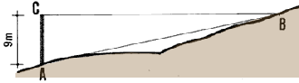
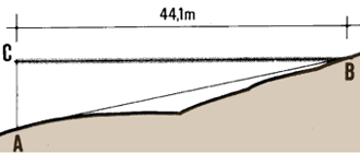
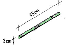
16. You also learned one way of correcting distance measurements, using slope (see Section 4.0, steps 10-13). 17. Another way of correcting distance measurements is to use measurements of height differences in the following formula: Horizontal distance = � (G2 - H2) |
Height difference
 |
|
| where G = AB is the distance measurement (in metres) along the sloping ground and H = AC is the height difference (in metres) between the two points. |
CB = � (G2 - H2)
 |
|
Example
|
Ground distance = 45 m
 |
|
|
Height difference = 9 m
 |
�(452 - 92) =
44.1
 |
5.1 How to use the straight-edge level |
||
|
1. You can make a simple device for measuring height differences over a small distance out of a mason's level (see Section 6.1) and a wooden straight-edge. |
 |
|
Making a straight edge |
||
|
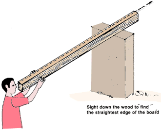
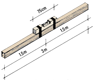
2. Get a piece of wood that is heavy enough to resist warping, and 2.5 to 3 m long. This piece of wood must be cut very carefully so that the edges are straight and squared-off. 3. When you have cut the straight-edge, hold one end to your eye and sight along the top and bottom edges to find which is the straightest. |
Make all the edges square and straight
 |
|
 |
||
Making a straight-edge level |
||
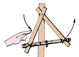
| 4. Using light string, lash a mason's level securely to the mid-point of the straightest edge of your straight-edge. Make sure that the mason's level is parallel to this edge. |
Lash the level to the straightest edge of the board
 |
|
Measuring height differences using the straight-edge level |
||
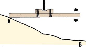
| 5. Set one end of the straight-edge level on the ground at the highest point A, and move the other end up or down until the edge is horizontal, using the spirit level the spirit level as a guide. | 6. Measure the vertical distance from point B on the ground to the bottom of the straight-edge level, using a graduated ruler, for example | |
|
When the level is horizontal...
 |
... measure the height difference
 |
|
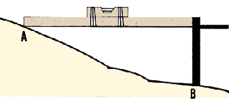
| Note: if the distance AB between the two points is greater than the length AC of the straight-edge level, you will have to measure intermediate points C, D, E ... B and add up all the heights to get the total height. |
Measure big differences in stages
 |
|
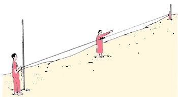
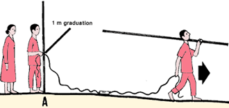
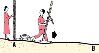
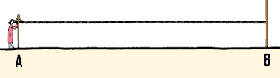
A mason's level and a cord form the basis of the line level. It is a simple device which you can use over a relatively long distance (up to about 20 m). You will need to work in a team of three people. You will also need two levelling staffs and some marking pins.
 |
Making your own line level |
||
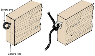
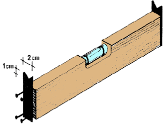
| 1. Get a cheap mason's level with a wooden case. Screw a strong screw-eye into each end-face, on the centre- line and close to the top. |
2. Get two 10-m-long cords and tie one of them to each
of the screw-eyes.
|
|
 |
 |
|
|
3. Wrap the loose ends of the cords with string to reinforce them. |
Wrap the ends of the cords for strength
 |
|
Using the line level for levelling |
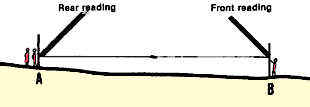
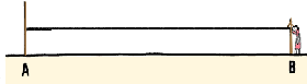
||
| 4. The rear person places a levelling staff on the starting point A of the line you are level-surveying. The end of one cord is put against the 1 m graduation of the staff. |
Put a levelling staff at starting point A
 |
|
| 5. The front person then takes a levelling staff, a marking pin and the end of the other cord, and walks away from the rear person, following the direction of the line being surveyed, and stopping when the cord is well stretched. |
When the cord is stretched tight, mark point 8
 |
|
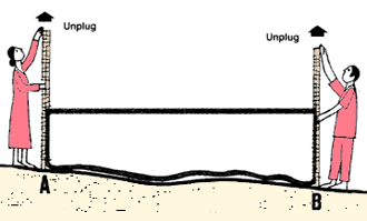
| 6. The front person places the second levelling staff vertically on the ground making sure that it is on the line being levelled. The end of the cord is pulled until the entire line level is as nearly horizontal as possible. This point is then marked with the marking pin. | 7. The centre person stands between the rear and front people and looks at the mason's level; then signals the front person to move the end of the cord up or down the levelling staff, until the spirit level indicates that the line is horizontal. If necessary, the rear person also moves that end of the cord up or down, to prevent the mason's level from touching the ground. | |
|
The centre person looks at the level...
 |
...and guides the front person until it is horizontal
 |
|
|
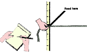
8. The rear person reads the height of that end of the cord on the levelling staff. The front person does the same. Be sure to double-check all measurements. Write down the measurements carefully, putting the rear measurements in one column and the front measurements in another column so you won't get them confused. (See the chart in step 10) |
Read the heights on the levelling staffs...
 |
|
|
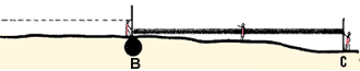
9. Then the front person removes the levelling staff from the ground and replaces it with a marking pin. The team progresses forward along the line, repeating the same procedure. The rear person should stop each time at the marking pin that the front person has placed for the previous measurement. |
... and write them in your notebook
 |
|
|
Begin the next measurements from point B
 |
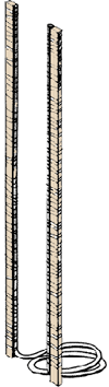
You can make a simple device for measuring level distances using a piece of transparent water hose 10 to 15 m long and two levelling staffs.
 |
Making your own water level |
|||
|
1 . If you do not have two levelling staffs, get two straight pieces of wood, 4 x 2 cm wide and 2 m long. Mark off a measuring scale in centimetres on each of them, or get two measuring tapes and glue them lengthwise to the pieces of wood. 2. When you mark the centimetre scales on the pieces of wood, place them side by side and align their tops and bottoms so that you can be sure both scales will be at exactly the same level. If you begin marking the scales 10 cm from the bottom of the wood, you can easily see where they begin, even if you are measuring in tall vegetation. Make sure that the bottom of each staff is flat or has a reference line*. |
 |
 |
|
|
3. Lay the two levelling staffs side by side in front of you, with their scales facing you. With strong string, lash the plastic hose along the length of the inside edges of the measuring scales. Make sure that the very ends of the hose are even with the tops of the staffs. The middle part of the hose will be loose between the two poles. When you fasten the hose to the poles, tie the string around the hose tightly enough to be secure, but take care not to pinch the hose. Make sure that the very ends of the hose are lashed to the scales. 4. On one point on the ground, place the two measuring scales side by side, with their scales aligned, in a vertical position. Slowly fill the hose with water, taking care to get rid of any air bubbles, until the level is about 1 m high in each of the upright sections of hose (the stand pipes) when they are held together. 5. Plug each end of the hose with a cork or another kind of stopper to avoid losing water when you carry the level. If you do lose any water, align the scales as you did before and refill with water to about 1 m. |
Lash the hose to the staffs
|
Fill the hose with water
up to 1 m high 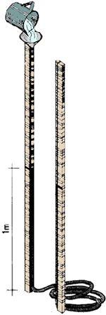 |
|
|
Plug the hose
 |
|||
Using the water level for levelling |
|||
| 6. To use the water level, you will need to work in a team of two people. The rear person stands at the starting point A of the line, and places one of the measuring scales in a vertical position on the ground. |
 |
||
|
7. The front person, carrying the other measuring scale and a marking pin, walks ahead along the line in the direction of the point where you want to find the difference in levels. When the end of the hose is reached the measuring scale is placed in a vertical position on the ground. Make sure that the levelling staff is directly on the line. 8. When the measuring scales are in position, both people remove the plugs in their ends of the hose. This is to ensure that the water in the hose will fall at the correct level. |
 |
||
|
9. Read the measuring scales with your eyes level with the surface of the water in the hose. 10. Replace the plugs in the ends of the hose. |
 |
Read the measurements and
write them in your notebook  |
|
|
11. Note down the measurements in a special table which will help you to calculate the height differences accurately (see Section 5.2, step 10). The front person marks the point where he or she is standing with a marking pin. 12. Progress forward, repeating the same procedure along the line. Each time you finish a section, the rear person should take a position at the marking pin left by the front person. |
Begin the next measurements from point B
 |
||
The T-bone level is a very simple level which is particularly useful for setting out canals or pipeline centre-lines. You use it together with a levelling staff, held by an assistant.
 |
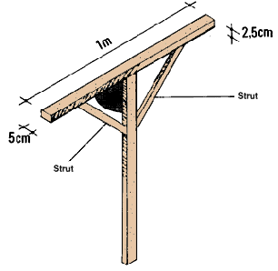
Making a T-bone level |
||
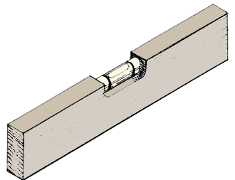
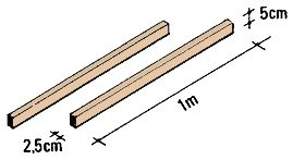
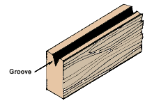
| 1. Get two 5 x 2.5 cm pieces of wood, each exactly 1 m long. | 2. Along the 2.5 cm face of one of these pieces, draw the centre-line. Make a shallow groove along this line with a saw. | |
 |
 |
|
|
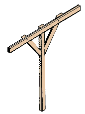
3. Lay the other piece of wood lengthwise on the ground, and centre the grooved piece, grooved side up, perpendicularly across it in a "T" shape. Make sure that their top sides are even and that they form an exact 90� angle. Nail the grooved piece in position to the other piece and add two support struts to hold it in place. The total height of the device should be 1 m. Note: to improve the accuracy of the level, you can make the horizontal top piece 1.5 m long rather than 1 m.
|
 |
|
 |
||
Using a T-bone level for levelling |
||
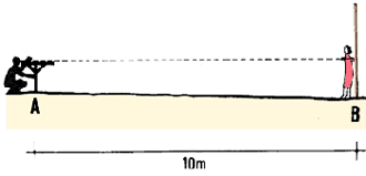
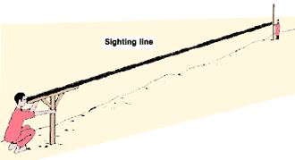
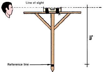
| 4. At the starting point A of the line you are level-surveying, stand with the T-bone level. Hold the base of the level firmly on the ground, avoiding stones or other objects which might cause it to wobble. Be sure the support is held vertically. |
Hold the level firmly in place
 |
|
|
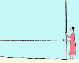
5. Have your assistant hold the levelling staff in a vertical position at the next point B of the line, about 10 m away. 6. Sight along the edge of the groove, as though you were sighting a gun, toward the graduation of the levelling staff. |
Sight along the groove at the levelling staff
 |
|
| 7. On the levelling staff, read the height corresponding to the T-bone level sighting line and note it down. Your assistant can help you by slowly moving a brightly coloured marker, such as a pencil or a pen, up and down along the levelling staff until you signal that it is level with the T-bone top edge. He or she then reads the height to you. |
Read the graduation at the line of sight...
 |
|
|
8. Note these readings down in a table and calculate the height differences (see Section 5.2, step 10). Note: since your T-bone level is exactly 1 m high, all you have to do to obtain the height difference between two points is to subtract 1 m from the reading on the levelling staff. |
... and write it in your notebook
 |
|
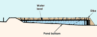
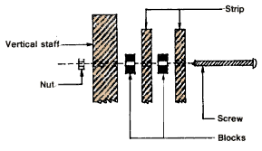
To make an improved T-bone level you can add a mason's level to the original device to help to make its sighting line horizontal. It can be used over longer distances, particularly to set out the top levels of pond dikes and to determine the water line of future reservoirs (see Vol.4, Water, Section 4.2).
 |
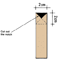
1. Get a mason's level with a wooden case and attach two metal sight pieces to its ends. To make them, cut two strips from a flattened tin. They should be the same width as the narrowest part of the mason's level, and about 2 cm longer than its height. Cut a V-notch 1 cm deep in one end of each strip. Nail the strips to the ends of the mason's level with the notches sticking up to create a line of sight along the top of the mason's level.
 |
 |
|
 |
||
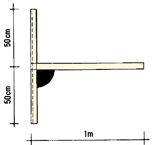
2. Get two pieces of wood, each 5 x 2.5 cm thick and about
1 m long. Assemble them with wooden support struts so that:
|
3. Centre your modified mason's level on the top piece and attach it. Then measure exactly 1 m from the sighting line at the top of the mason's level down the support piece. Clearly mark this reference line* with paint or with a narrow piece of wood nailed across the support. Below this mark, shape the support into a point. | |
 |
 |
Using the improved T-bone level for levelling |
||
|
4. You use the improved T-bone level the same way as the simple T-bone level (see Section 5.4), except that:
|
Drive the stake down to the reference line
 Make it horizontal with the mason's level |
|
|
Sight at the levelling staff
 |
||
| Note: the sighting line will be exactly 1 m above exactly 1 m above point A where the improved T-bone level is positioned. Knowing this, you can easily determine the other points B, C, ... G of the site that are 1 m higher than your levelling station A by standing on the same point and levelling around in a circle. |
 Rotate the level to find all the points 1 m higher than point A |
|
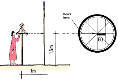
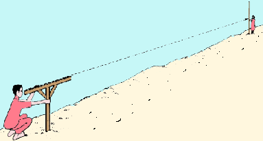
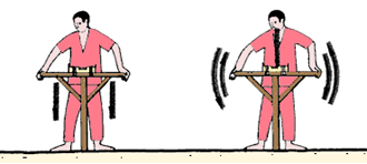
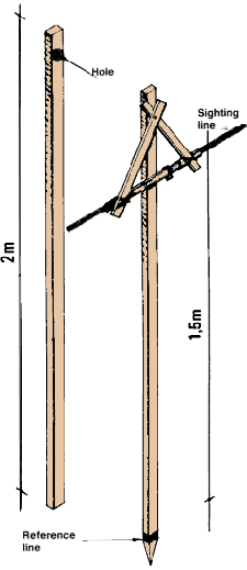
You can make a simple device for level surveying from a small bamboo tube and several pieces of wood. It should be used with a levelling staff. It is very sensitive to wind and breezes. When you use it, make sure that the sighting tube remains horizontal while you are reading heights.
 |
1. Get a piece of bamboo about 45 cm long and a few centimetres in diameter. Remove the inside membrane between its sections by drilling, or by driving a long object such as a metal rod through the tube.
 |
Remove -membranes from the tube with a rod
 |
2. Across one end of the bamboo tube, glue two pieces of wire or thread at right angles to form a central sighting point.
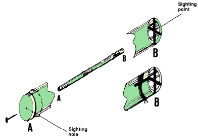 |
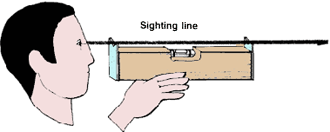
| 3. Cover the other end of the tube with tape. Waterproof plastic or electrical tape is best. Pierce the tape at its centre with a small nail, to make a sighting hole. When you use the level, you will look through this hole and read the measurement at the point where the two threads cross. |
 |
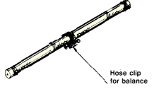
| 4. Place a small weight on the bamboo tube which can be moved along the tube to balance it. A hose clip makes a good balance, and it can be tightened to keep it in place once the tube has been horizontally adjusted. |
 |
|
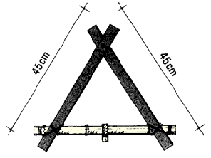
| 5. Lash two 45 cm wood strips to opposite sides of the tube, near the ends, so that they form a triangle with the bamboo tube. |
 |
|
| 6. Drill a hole through each wooden strip at a point about 7 cm from the top. |
 |
|
| 7. Get a 2 m vertical staff, and drill a hole through it near the top; the triangle sighting device will hang from this. |
 |
|
|
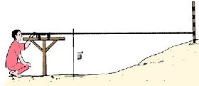
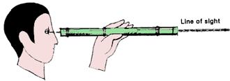
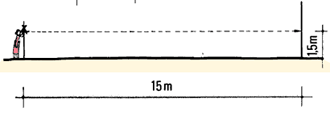
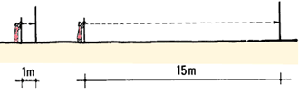
8. To allow the triangle to move freely, place small blocks of wood or short segments of bamboo between the wooden strips of the triangle where they cross at the top and between the back of the triangle at this point and the vertical staff. 9. Loosely bolt the triangle, through the wooden blocks or bamboo segments, to the hole in the vertical staff. The sighting line should be exactly 1.50 m from the ground. This height is convenient for both calculations and sighting. With the bamboo sighting tube perpendicular to the support staff, measure the vertical distance from the centre of the tube to the bottom of the staff. Mark a reference line 1.50 m below the line of sight. |
 |
10. Place the bamboo sighting level close to a 2 m measuring scale or levelling staff. Read the height on the scale by sighting at it through the small hole and reading the number that lines up with the crossed threads.
|
Check from 1 m away... |
| 11. Move the measuring scale to a point which is 15 m away and at the same level. Check that this point is at the same level (with a straight-edge level, for example, see Section 5.1). Sight again through the bamboo tube and read the height on the scale to see if it is the same as before. |
... and from 15 m away
 |
|
| 12. Check to see that the triangle is hanging freely by moving it with your finger. Let the triangle come to a stop and check the reading through the bamboo tube again to see if the result is the same. |
Swing the triangle, then test again
 |
|
| 13. If the reading at the 15 m point is not the same as the reading from the point where the bamboo level and measuring scale were side by side, adjust the balance weight on the bamboo tube slightly. Move the weight towards the rear of the tube if the 15 m reading is lower; move it forward if the reading is higher. |
If the reading is low, move the weight back
 |
|
| 14. Again place the bamboo sighting level and the measuring scale or staff side by side, and take a new reading. |
If the reading is high, move the weight forward
 |
|
|
15. Move the scale or staff 15 m away, and check this reading. 16. Repeat this process (see above, steps 10-15) until the two readings are the same.
|
Keep testing until the sighting-tube is balanced
 |
|
|
Note 1: If there is a small difference between the two readings after several repetitions, it may be caused by a slight difference in level between the two points. Interchange the positions of the bamboo level and the scale, putting the level at the 15 m point and the measuring scale at the 0 m point. Take another reading. Divide the difference in the readings by 2. Then, using this figure, make the bamboo tube horizontal by moving the balance weight along it. |
If the reading is still different...
 |
|
|
... exchange the positions of the level and the
staff
 |
||
| Note 2: when the reading taken from 15 m away is within 2 cm of the reading you took with the bamboo level and the scale side by side, your bamboo level is accurate enough. |
A variation up to 2 cm is acceptable
 |
Using the bamboo sighting level for levelling |
||
|
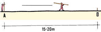
17. To use the bamboo sighting level you will need to work in a team of two people. The distance you can survey each time depends on how far away you can read the levelling staff graduation (usually 20 m, at the most). 18. You can level in either one or two directions, as described below. Note:the bamboo level should be placed at each station so that the sighting line is 1.50 m above ground level. |
 |
|
Levelling in one direction only |
||
|
19. Place the bamboo sighting level in a vertical position at point A, the beginning of the line you are surveying. 20. Your assistant should walk ahead 15 to 20 m along the line and place the levelling staff in a vertical position at point B, and mark point B with a stake. |
 |
|
|
21. Take a reading on the levelling staff, from point A to point B and note it down. Then move forward to point B, and set up the bamboo sighting level where the stake was. 22. Your assistant should walk ahead another 15 to 20 m along the line. There the levelling staff is placed in a vertical position at point C which is marked with another stake. |
 |
|
|
23. Now take a reading on the levelling staff from point B to point C. |
Read the levelling staff at the sighting
line and write the reading In your notebook  |
|
|
24. Repeat this procedure (see steps 22-23) until you have surveyed the entire line. 25. Carefully note down all the readings in a table and calculate the heights of the various points, if you need them (see Section 5.2). |
Move to the next station
|
|
| 26. When you have reached the end of the line you are surveying, you can also calculate the total height difference between the starting and the finishing points (see Section 5.2). |
Add up all the readings
|
|
27. You can measure two lengths of a line from a central point by sighting with the bamboo level in two directions. This system gives you two readings for each point except the first and the last. By comparing the forward reading (FR) and the back reading (BR) you can check the accuracy of your work.
28. Your assistant should place the levelling staff in a vertical position at the starting point A on the line you need to survey.
29. Walk ahead 15 to 20 m along the line and place the bamboo level at point B. From there, take a back reading (BR) from point B to point A.
|
Take a back reading and write it down
 |
 |
30. Your assistant should then pace this distance to you, and then pace the same distance past you to the next point (C) ahead, where the levelling staff is placed.
31. Turn the bamboo level around at point B and take a forward reading (FR) from point B to point C.
|
Turn the level around and take a forward
reading, then write It down 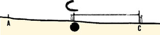 |
 |
32. Repeat this process until you have surveyed the entire line.
|
At the next station, note the back reading...
 |
 |
33. Note down all your readings in a table and calculate the height differences between the surveyed points (see Section 8.1)
|
... and the forward reading
|
 |
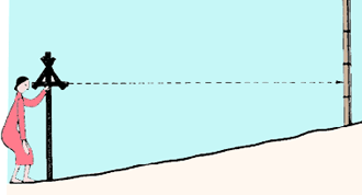
5.7 How to use the hand level |
||
|
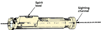
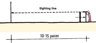
1. The hand level is a ready-made tool for quickly finding differences in level. Its range in the field should not exceed 15m. You may be able to borrow a hand level from a local survey station or buy one from a hardware store. The hand level is made up of a sighting channel, a spirit level and a mirror. The mirror allows you to take a reading and, at the same time, check to see that the sighting line* is horizontal. |
 |
|
Using the hand level for levelling |
||
|
2. The directions for using the hand level are the same as those given for the bamboo sighting level (see Section 5.6), except that:
|
 |
|
| Note:you can have greater accuracy if you rest the hand level on the top of a wooden pole of convenient height. In this case, the height of the pole becomes the height of the sighting line. |
 |
|
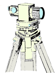
5.8 How to use the surveyor's level and theodolite |
||
|
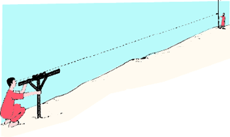
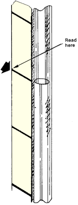
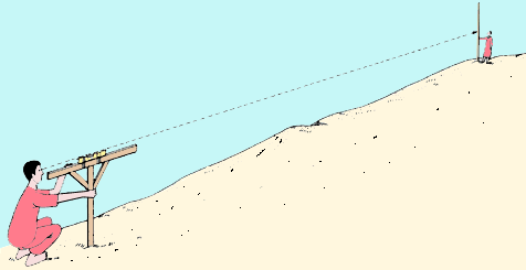
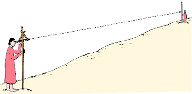
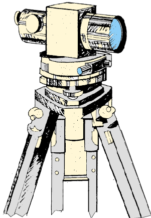
1 . For very accurate levelling over long distance surveyors use modern instruments called surveyor's levels and theodolites. These instruments are expensive and can be damaged easily. Only skilled personnel should operate, adjust and repair them. 2. To level survey a small farm you will not usually need the high accuracy of these instruments, and you may use cheaper devices. You have learned about these in earlier sections. However, either a surveyor's level or a theodolite may be available for your survey. Both should be used with a modern levelling staff (see Section 5.0, step 8) to give the greatest accuracy. The levelling staff is set vertically on the ground so that its graduation marks are upside down, since the sighting devices on the surveyor's instruments invert the images, making them appear upside down. 3. A surveyor's level is basically a telescope, fitted with cross-wires for sighting, and attached to a levelling device which is mounted on a tripod (a support with three legs). In older instruments, the horizontality of the sighting line was adjusted with a sensitive spirit level and fine-threaded adjusting screws. In more recently made instruments (known as self-levelling or automatic levels), the line of sight is automatically brought to the horizontal, which makes surveying operations much easier. The telescope magnifies far-away objects, which means you can observe the graduation on a levelling staff at a much greater distance than you could with your ordinary eyesight. |
 |
|
4. Theodolites are commonly used to measure horizontal angles (see Section 3.5) and vertical angles (see Section 4.7). They can also be used to measure height differences.
5. Most surveyor's levels and theodolites are equipped with stadia hairs. These allow you to determine distances during level surveys (see Section 2.8).
6. Height differences are measured by using the horizontal sighting line as a reference, as described for the bamboo sighting level (see Section 5.7). These differences are recorded and calculated as explained in Section 8.1. Very long lines can be surveyed much faster, without measuring as many intermediate stations.
|
Measuring horizontal angles
 |
![]()