GEOGRAPHY, POPULATION AND WATER RESOURCES
Zimbabwe is a land-locked country in the Southern African Region, and has an area of 390 076 km²
Total population was estimated at about 11 million in 1994. In 1992, 70% was rural and the annual demographic growth rate was about 3.2%.
TABLE 1
Basic statistics and population
| Area of the country | 1993 | 39 076 000 ha |
| Cultivable land | - ha | |
| Cultivated land | - ha | |
| Total population | 1994 | 11 002 000 inhab. |
| Population density | 1994 | 28 inhab./km² |
| Rural population | 1992 | 70 % |
| Water supply coverage | ||
| Urban population | 1993 | 100 % |
| Rural population | 1993 | 61 % |
Agriculture contributes between 30 to 40% to total exports and 14% to GDP, with most crops being produced under rainfed conditions.
Climate and water resources
Average annual rainfall is 652 mm, but ranges from 1 000 mm in the Eastern Highlands to around 350 to 450 mm/ year in the lowveld in the South. About 90% of the precipitation occurs during the period of mid-November to early April. The winter season is from April to August, and the hottest and driest period is from September to mid-November.
Zimbabwe is bordered to the north by the Zambezi and to the south by the Limpopo, both rivers flowing into Mozambique. Together with the Save in the east, they collect most of the streams emanating from the Highveld, a plateau which runs diagonally across the country. Most of Zimbabwe's rivers dry up a few months after the rainy season and, by the end of each dry season, major rivers such as the Limpopo and Save become "rivers of sand," with only few scattered pools. It should be noted, however, that the rivers carry large volumes of interflow. In fact, during drought years, sand-point abstraction (a technique for extracting water from the sand layers in the river beds) is the most reliable form of water supply.
Internally produced water resource amount to about 14 km³/year. The potential yield (probably including external resources) is estimated at about 13 km³/year, of which 29% (3.8 km³/year) is currently used. The estimated groundwater potential is between 1 and 2 km³/year.
TABLE 2
Water balance
| Water resources: | |||
| Average precipitation | 652 | mm/yr | |
| 254.9 | km³/yr | ||
| Internal renewable water resources - total | 14.1 | km³/yr | |
| Internal renewable water resources - per caput | 1994 | 1 282 | m³/yr |
| Global renewable water resources | 20.0 | km³/yr | |
| Dependency ratio | 29.5 | % | |
| Total dam capacity | - | km³ | |
| De-salinated water | - | 10 6 m³/yr | |
| Water withdrawal: | |||
| - Agricultural | 1987 | 963.8 | 10 6 m³/yr |
| - Domestic | 1987 | 170.8 | 10 6 m³/yr |
| - Industrial | 1987 | 85 4 | 10 6 m³/yr |
| Total | 1 220.0 | 10 6 m³/yr | |
| per caput | 1987 | 135 | m³/yr |
| as a % of internal renewable water resources | 8.7 | % | |
| Other withdrawal | - | 10 6 m³/yr | |
| Wastewater: | |||
| Produced | - | 10 6 m³/yr | |
| Treated | - | 10 6 m³/yr | |
| Re-used treated wastewater | - | 10 6 m³/yr |
TABLE 3
Irrigation and drainage
| Irrigation potential | 1993 | 331 000 | ha |
| Irrigation: | |||
| 1. Full or partial control Irrigation: equipped area | 1993 | 116 577 | ha |
| - surface irrigation | 1993 | 21 144 | ha |
| - sprinkler irrigation | 1993 | 87 433 | ha |
| - micro-irrigation | 1991 | 8 000 | ha |
| % of area irrigated from groundwater | - | % | |
| % of area irrigated from surface water | - | % | |
| % of equipped area actually irrigated | - | % | |
| 2. Spate irrigation area | - | ha | |
| 3. Equipped wetland and inland valley bottoms | - | ha | |
| 4. Other cultivated wetland and inland valley bottoms | 1993 | 20 000 | ha |
| 5. Flood recession cropping area | - | ha | |
| Total water managed area (1+2+3+4+5) | 1993 | 136 577 | ha |
| - as a percentage of cultivated area | - | % | |
| - increase over last 10 years | - | % | |
| - power irrigation as % of water managed area | - | % | |
| Full or partial control schemes: Criteria | |||
| Large schemes > - ha | 1993 | 93 656 | ha |
| Medium schemes | - | ha | |
| Small schemes < - ha | 1993 | 9 421 | ha |
| Total number of households in irrigation | |||
| Irrigated crops: | |||
| Total irrigated grain production | - | t | |
| as a % of total grain production | - | % | |
| Harvested crops under irrigation | 1989 | 178 547 | ha |
| - wheat | 1989 | 47 500 | ha |
| - cotton | 1989 | 39 486 | ha |
| - sugar cane | 1989 | 31 767 | ha |
| - soybean | 1989 | 15 000 | ha |
| - other | 1989 | 44 794 | ha |
| Drainage - Environment: | |||
| Drained area | - | ha | |
| as a % of cultivated area | - | % | |
| Flood-protected area | - | ha | |
| Area salinized by irrigation | - | ha |
In 1987, water withdrawal was estimated to be 1.2 km³ (Figure 1); in 1990 it was about 3.6 km³
IRRIGATION DEVELOPMENT
Land suitable for irrigation in Zimbabwe is estimated to be more than 550 000 ha, but water availability reduces this potential to 331 000 ha. It is estimated that this development could be achieved in 20 to 30 years.
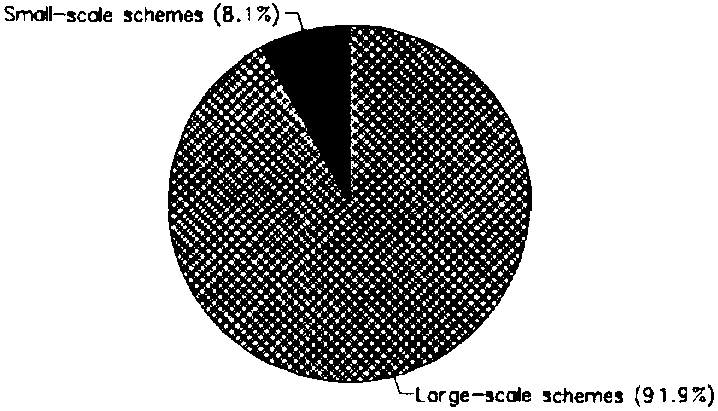
Irrigated areas have increased substantially in the last 25 years, more than tripling, from 60 000 ha in 1968 to 191 000 ha in 1990, including double-cropped areas. Between 1982 and 1985, the irrigated area dropped from 165 000 ha to 136 000 ha as a result of the severe drought (Figure 2). In 1993, full or partial control irrigated areas (called 'formal irrigation') was about 116 600 ha, while cultivated wetlands and gardens (called 'informal irrigation') represented about 20 000 ha (Figure 3). In the dualistic system which is characteristic of Zimbabwean agriculture, there is almost no intermediate position between the large- and the small-scale farmers. Most of the areas developed for full or partial control irrigation are large-scale commercial private and parastatal schemes (107 156 ha), while small-scale schemes cover only 9 421 ha (Figure 4).
As far as full or partial control irrigation management is concerned, four categories can be distinguished (Figure 5):
FIGURE 1: Water withdrawal (total: 1.22 km³ in 1987)
FIGURE 2: Evolution of the irrigated area, including double cropping
FIGURE 3: Types of full or partial control irrigation schemes (1993)
In 1988, 93 % of large-scale private schemes had an area larger than 50 ha, and 62% were larger than 250 ha, while the settlers' average irrigated area was 2.6 ha.
In 1992, about 87 000 ha of the full or partial control equipped area was under sprinkler irrigation (traditionally used on commercial farms), with surface irrigation on most of the remaining area, barring 8 000 ha of micro-irrigation (Figure 6). In small gardens, water can also be provided by hand from nearby water pools or hand-dug wells.
Most water for irrigation is pumped from regulated-flow rivers or stored in farm reservoirs, known locally as 'dams'. Water is currently treated as a free commodity. Starting from 1986, a National Blend Price for water has been applied to charge the commercial farming group for water from dams, based on the capital investment and operation and maintenance (O&M) cost.
In 1990, the on-farm (in-field works) investments for small schemes irrigation development ranged from $US 1 250 to 2 900/ha, depending on the irrigation techniques. Annual O&M costs were estimated at $US 220/ha and $US 40/ha for sprinkler and surface irrigation systems respectively.
In 1990, it was estimated that about 40% of the nine principal crops' value was produced under irrigation. Major irrigated crops are wheat, cotton, sugar cane, soybean, tobacco and maize (Figure 7). The winter: summer irrigated area ratio is 1:1.6.
FIGURE 4: Distribution of the water managed areas (1993)
FIGURE 5: Irrigation management, full or partial control (1993)
FIGURE 6: Irrigation techniques, full or partial control (1991)
Some major environmental issues which are related to irrigation are soil erosion (with severe impact on communal lands), siltation (of dams, intake structures, pumps, canals), and water pollution (due to agrochemicals).
INSTITUTIONAL ENVIRONMENT
- The Department of Agricultural, Technical and Extension Services (AGRITEX) has the mandate for irrigation development, and is directly involved with the planning, design and operation of most smallholder irrigation schemes. It coordinates and directs donor participation in irrigation development.
- The Department of Water Resources and Development (DWRD) is in charge of water resources management.
Milestones in water-related legislation are: the Land Assessment Act (1951), the Sabi Limpopo Authority Act (1964) (together with the Agricultural and Rural Development Authority Amendment (1982)) and the Regional Water Authority Amendment (1987), the Land Tenure Act (1969), the Water Act (1976), and the Natural Resources Border Act.
TRENDS IN WATER RESOURCES MANAGEMENT
In Zimbabwe, the limiting factor in irrigation development is water availability. Provision of water depends almost entirely on expensive storage works. A way to increase irrigated area at marginal cost of in-field development and without public funds could be to lower the reliability levels of regulated water from 90 to 80%.
FIGURE 7: Irrigated crops (1989)
Historically, irrigation development has largely been a function of private investment. With the significant exception of the construction of large dams, the large-scale private commercial sector is capable of expanding its irrigated area without specific Government support. The present concept for commercial small-scale farmers is to have a core estate which carries the cost of providing management assistance and services to the farmers as part of its overheads. An alternative is to have a pluriform scheme where both large- and small-scale operations are mixed, and where smaller farmers hire services from the larger farmers at commercial rates.
The real limitation on the rate of communal irrigation development is the absorptive capacity of the system as a whole. Communal irrigation is an exercise in community development in which irrigation is the major, but not the only element. The success of individual schemes can be correlated to the experience of the irrigators and their sense of community. Community development and involvement in the creation of new projects and in training leaders and irrigators is necessarily a slow process.
MAIN SOURCES OF INFORMATION
FAO. 1990. Irrigation subsector review and development strategy. Project TCP/ZIM/8955. Rome.
FAO. 1993. Country Action Programme: Zimbabwe.
Modern Farming Publication. 1991. Commercial Agriculture in Zimbabwe 1990/91.