![]()
![]()
![]()
Following the development of the demonstration project it was decided not to break into working groups but rather jointly define a strategy for forming a global land network. The participants made a number of recommendations to the GTOS Steering Committee that if accepted would result in an initial GOS-Net. (See Section 7.)
The need for global data falls into two basic categories: 1) requirements for data sets to solve global scale problems, and 2) requirements for local or regional data sets on a world-wide basis. The two environmental themes require global in situ data sets if we are to respond to the changes that are occurring. Climate change, its detection, prediction and understanding its impacts clearly requires global data sets. Furthermore, the understanding and management response to desertification and land degradation requires global climate data sets.
Local to regional data sets collected world-wide are needed to address local to regional problems that are so pervasive that they occur around the globe. These include pollution by toxic substances, fresh water resources, and the loss of biodiversity. In these cases comparable data sets help focus attention on these issues and provide information for a global assessment of whether or not improvements are occurring and where further concerted international action may be required.
The participants indicated the interest of their networks was in assisting the Global Observing Systems to obtain required in situ data. They also felt that participation in a global network could enhance their effectiveness in a number of ways, including:
Facilitating access to comparative data from a wider range of sites to improve the interpretation of their own data;
Making and consolidating contacts between scientists in other parts of the world to improve collaboration in projects designed to attract additional funding for monitoring and research initiatives;
Promoting increased local awareness of international and global issues;
Obtaining assistance from GTOS in making global products useful at the regional and local level;
Acquiring and transferring knowledge regarding new methods to the member sites and scientists;
Gaining better and easier access to space-based observations;
Gaining help in developing proposals for capacity building within local networks;
Increasing the opportunities for student training.
There was a discussion as to the scope of the network. Initially GOS-Net will be limited to those networks and sites that are making ecologically relevant freshwater or land-based observations. However it was concluded that a global network of existing networks and sites that was to serve all in situ GTOS and GCOS observational needs must include coastal zone area, hydrology and the cryosphere. (Because of their interest in coastal zones GOOS should be contacted to determine their interest in participating in such a network.) It was pointed out that there were separate efforts underway to develop a network of glacier and permafrost sites. It was recognised that a network of hydrological sites was also critical. GCOS and GTOS are well aware of significant efforts ongoing in particular the Flow Regimes for Experimental and Network Data Sets (FRIENDS) project, World Hydrological Cycle Observing System (WHYCOS) and the Global Runoff Data Centre (GRDC) which will be used to begin the formation of a hydrological network in the near future.
There are a number of issues regarding methods, and data and information that need to be addressed by the global observing systems in general and by GTOS in particular. Two of short-term concern are a clearly defined data policy that articulates the Global Observing Systems, view regarding the availability of data and the timeliness with which data should be made available, and development of a set of standards for metadata (information about data sets). Some of the networks do not have metadata standards, but there was concurrence that metadata standards are crucial and those GTOS metadata standards need to be developed. There was insufficient time to fully develop these issues, hence the participants present agreed that they would send their existing data policies to the GTOS Secretariat and recommended that the Joint Data and Information Management Panel (JDIMP) develop a policy as soon as possible.
For a GOS-Net to respond to the Global Observing Systems’ needs, it is necessary for the Global Observing Systems to clearly define the required variables. It was recognised that the climate variables have been well defined by the TOPC. However, the participants urged the GTOS Steering Committee to define the additional variables and requirements for the other priority issues as soon as possible. It was recommended that this be done in a two-step process. First using readily available information, develop a preliminary list of variables. Secondly undertake a more careful detailed examination of each variable to be sure that it is needed on a long-term basis. Information in the Report of the Conventions (See footnote 2, page 2) and from the DIVERSITAS programme provide excellent starting points for an initial cut at the required core variables. Such an analysis would assist not only the implementation of a GOS-Net, but more importantly it would provide an important input to Version 2.0 of the Global Observing System Space Plan.
The participants agreed that as a first step in forming a network that exchanging Internet addresses, so as to be able to refer to each other’s pages, was a good idea. The home page addresses of those present at the meeting are available in Annex III.
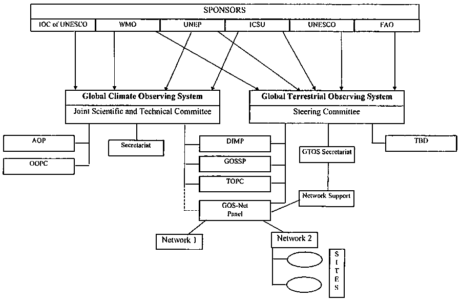
An organizational structure and support for a network of ecological sites are critical. A recommended organizational structure was developed (See Figure 1). While supporting the land-based needs of all G3OS’s, organizationally it was felt that a network of ecological sites should be administered by one of the global observing systems. While currently the climate requirements are most clearly defined in the long term it was recommended to the Sponsors of the G3OS that GTOS take the lead in providing secretarial support to the network. It must be recognised that the network must meet the needs of GCOS and GOOS. The proposed diagram reflects this recommendation.
The networks participating in GOS-Net need to have a major say in how the network will be operated, hence the recommendation to have a Network Panel. The Network Panel would initially consist of representatives from all the participating networks plus additional representatives from the GTOS Steering Committee and the JSTC of GCOS.
It was recognised that there is a need to have secretariat support for GOS-Net, and that this will require resources. The participants agreed that the GOS-Net Secretariat need not be physically co-located with the GTOS Secretariat, but the lines of communication should flow both ways through the GTOS Secretariat. Dr Gosz, Director of the U.S. LTER programme and Chairman of the U.S. LTER network felt that U.S. LTER/ILTER might be able to obtain the resources, including necessary computer support, to provide a GOS-Net Secretariat by co-locating it with the LTER/ILTER office in New Mexico. The GOS-Net Secretariat would report directly to the GTOS Secretariat. Since no other similar alternatives have been identified the participants recommended that the GTSC and the JSTC request Dr Gosz to vigorously pursue this possibility.
It was recognised that not all networks were present at this meeting, and that national networks as well as individual sites are likely to have essential contributions to make to the GOS-Net. The participants felt that while those present at the meeting should be invited initially a provision should be made which will facilitate the incorporation of other networks or individual sites in the network. To this end, a two-stage procedure was suggested. First, a fact sheet should be requested from a prospective new member concerning its site(s), data and practices. Second, a letter of invitation will be sent by the GTOS Steering Committee to join the network after recommendation by the Network Panel. As a minimum the following information should be obtained from each network prior to issuing consideration of an applicant:
Name of the Network or site:
Goals and Objectives:
Scope and Geographic Coverage (including number of sites):
Needs from the GOS-Net:
Ability to Contribute to GOS-Net:
Ability to Contribute to Demonstration Project:
Data Policy:
Training requirements:
URL for Website if available:
Contact Name, Address, Phone, Fax and Email.
The participants also developed a list of tasks and a proposed timetable for the establishment of an initial GOS-Net. (See Table 1.)
Figure 1. Relationship between GCOS and GTOS Panels
Table 1. Possible Timetable for Implementation of GOS-Net and the Demonstration Project.
![]()
![]()
![]()