![]()
A reconnaissance survey carried out by an Aquaculture Mission sponsored by the Indian Ocean Programme (IOP) and the Aquaculture Development and Coordination Programme (ADCP) in April-May 1976 indicated that the tidal swamplands along the coasts of Kenya and Tanzania are potential areas for coastal aquafarm development. The mission recommended that a pilot farm should be established on the coast of Kenya to test the technical and economic viability of aquaculture under local conditions. If the farm proved successful, it should serve as a demonstration and training centre for both Kenya and neighbouring countries of East Africa. ADCP therefore organized a more detailed investigation with the assistance of the Department of Fisheries in Kenya to select a suitable site and design the pilot farm and its operation. Mr. Y.A. Tang, Senior Fishery Officer (Aquaculture) ADCP, undertook the study in February–March 1977, with the assistance of local counterpart personnel. Owing to limitations of time and facilities, it was not possible to make as detailed investigations and topographical surveys as were desirable. However, the data collected were considered adequate to prepare the basic plans and estimates required for the establishment of the farm. Modifications and changes may have to be incorporated based on further information that may become available during the initial phase of the project.
The Government proposed five sites for the pilot farm; two located in Mombasa (Mamduda and Maunguja) and three in Malindi (Dabasso, Kadana and Ngomeni), all of which may be considered generally suitable for coastal aquafarm development. However, none of them fulfil all the technical, socio-economic and institutional requirements. The criteria that were finally used for selecting the site relate to: (i) favourable aquafarming environment, (ii) lower construction cost, (iii) better transportation system, (iv) less water pollution risk, and (v) easy acquisition of land. A rough evaluation of these factors is as follows:
| Criteria | Proposed project sites | ||||
| Mamduda | Maunguja | Dabasso | Kadana | Ngomeni | |
Land elevation and soil and water quality | good | fair | not very favourable | fair | good |
| Construction cost | low | high | high | high | high |
| Accessibility by land and water | good | not easily accessible | fair | fair | fair |
| Pollution risk | high | low | low | low | low |
| Possibility of land acquisition1 | good | good | good | good | difficult |
Mamduda area: This area is situated at the northwestern part of Port Reits and borders on Mipirani, Mombasa City. The advantages of the area are its good transportation system and facilities plus the short distance from the Provincial Office of Fisheries Department which would facilitate farm operations. The salinity range in the area is from 26 to 30 ppt during the dry season in February. One of the most serious disadvantages is the risk of oil pollution, as the Ras Makadini jetty used for transferring crude oil from tankers to oil refineries is only at a distance of 7 km.
Maunguja area: The area is located at about 20 km northwest of Mombasa City. The environment appears favourable for aquafarm development but the site is not accessible by motorable road.
Ngomeni area: The area is about 25 km north of Malindi. The mangrove belt is about 9 km long and 3 km wide. A solar salt field of about 200 ha has been constructed on the tidal land and an additional 500 ha is now under construction. It is reported that the salt company has acquired about 2 500 ha from this mangrove swamp. This tract of land is, therefore, no longer available for coastal aquafarm development.
Dabasso area: The area is located at Mida Creek, about 16 km south of Malindi and is accessible by motor road. The environment is favourable; however, soil profile indicates the presence of huge rocks in the subsoil in many places. These rocks may affect the cost of pond construction and cause leakage in dike foundation.
Kadana area: As can be seen from the evaluation on page 1, this area is the one that has no negative characteristics other than a relatively high construction cost. The site was therefore chosen for the establishment of the pilot farm and detailed site surveys were undertaken.
The area is located around 39°55' longitude East and 3°18' latitude South along the Mida Creek, a coastal lagoon with about 2 800 ha surface area at high tide. The average depth at mean tidal level is less than 1.5 m. The outlet of the lagoon to the sea is about 600 m wide. The mangrove forests along the coast of the lagoon cover about 1 200 ha, of which 70 percent (about 800 ha) is located in the Kadana area.
With the exception of the major channels and adjacent areas, the lagoon bed is situated at an elevation above the tidal level of mean lower low water. During low tides, most of the areas are either exposed or too shallow for use by even small boats.
The lagoon has a catchment area of about 160 km2 extending to the northwestern hilly lands, up to an elevation of about 150 m above sea level. But owing to a limited amount of rainfall and the highly permeable nature of the soil, the creek does not receive enough fresh water to maintain a constant flow.
The elevations of the mangrove swampland are about 2.8 m to 3.2 m wide with an average of 3.0 m above the assumed datum plain (the tidal level of mean lower low water). This was estimated on the basis of observations of tide level and inundation. The ground is so flat that these estimates are possibly without significant errors. However, it is suggested that a topographic survey of the area should be carried out to trace the water way contour lines. This is required to design a suitable drainage system, essential for the improvement of the farm soil.
Tide: The tides at Malindi can be calculated from the “Tide Table” published by the Mombasa Harbour Authority. Observations of the tidal range at the project site between 17 and 19 February 1977 indicated that high water at spring tide in the Kadana area reaches 3.8 m above the designed datum level. The time difference, however, is about 0.7 hour (later than in Kilindini).
Rainfall and evaporation: According to the records at the Malindi Gedde Cotton Research Station for the period 1957–1970 the mean annual rainfall is about 1 220 mm. Of this, 60 percent is between April and July. The maximum recorded rainfall in 24 hours is 156 mm during this period.
The mean annual evaporation on the basis of eight years' records from 1963 to 1970 is approximately 1 950 mm. The mean annual water loss through evaporation in this lagoon is approximately 2 000 m3/ha. Of this, 30 percent is expected to occur between January and March.
Flood: The measurement of water flow from Mida Creek during the rainy season is not available. Judging from the size of the culvert constructed under the motorway across the northwest side of the creek, it appears that flooding even in very heavy rainfall is not significant.
Temperature: The mean monthly temperature is between 23° and 27°C with extremes ranging from 17° to 34°C.
Sunshine and radiation: The mean sunshine is 8.9 hr/day and the mean radiation 445 cal/cm2/day.
Wind: The region is almost free from cyclones. The monthly wind speed ranges from 6.2 to 16.6 km/hr with a mean of 9.6 km/hr. In view of this, special protective measures for earth structures do not appear necessary.
The soils of the area are probably formed by recent alluvial deposits. They have a relatively light texture, with a high percentage of fine sand and silt. They may be classified as sandy loam.
The organic matter content of the soils is rich but pH value of the subsoil may be low because soil samples taken from 0.6 m below the surface indicated the presence of iron sulfide.
From field observations, it appears that the soil is characterized by a low bulk density and low plasticity which would make it poor material for the construction of embankments and result in low-bearing capacity of structural foundation. However, the earthworks of the Fundisa salt field indicate that this type of soil could be successfully used for small embankments with a height of less than 2 m. When such soils are used, a higher maintenance cost should be expected because of likely serious erosion.
Information on the fluctuation of water salinity in the lagoon is not available. A test on 17 February 1977 showed the salinity to be about 35 ppt during a high tide. It is likely that the salinity of the lagoon would be similar to that of the adjacent sea even during the wet season.
The land surrounding the lagoon is not intensively cultivated. It is, therefore, unlikely that water pollution caused by agricultural chemicals would affect the project area.
Avicennia and Rhizophora are two dominant genera of mangrove in the tidal swamps. Counting of a random sample showed 700 trees/ha (with wood more than 15 cm in diameter) of which approximately 70 percent are Avicennia. Large Rhizophora of more than 30 cm in diameter occur along the banks of the channels. It is suggested that these large Rhizophora be preserved for land protection.
The project site is accessible by an all-weather road. A number of villages are scattered along the Mida Creek area. Most of the villagers are engaged in farming, and maize, cotton and coconut are the major crops. The average family income in the area is about K.Sh. 4 000/annum, which is about the lowest level of rural family income in Kenya.1
According to the Chief of Watamu village, unemployment is one of the serious social problems in the area and there is considerable excess labour that could be utilized in economic development activities.
The mangrove tidal lands in the Kadana area cover about 800 ha. Three major tidal channels run through the mangrove forest and divide this tract of land into five sections. The section selected for the project site is situated opposite the Sudi Island and near Uyombo village (See Figure 1).
The site will be enclosed by a perimeter dike of 2 600 m: 1 600 m along the bank of the tidal channel at ground levels of 2.8 m to 3.0 m, and 1 000 m along the highland at ground levels of 3.0 m to 3.2 m (the elevations are based on the design datum plain of the farm site). The enclosed area will be partitioned into ten production ponds with individual sizes ranging from 2.0 ha to 5.5 ha and two nursery ponds with an area of 0.75 ha each. The production ponds will be of rectangular shape with the long side facing the southwest monsoon winds. An interceptor drainage canal will be dug across the natural waterways of the site ending at the two main watergates. A road system for the passage of light trucks is to be constructed along the canal bank. A general description of the farm is given below (See Figure 2):
| Ponds | |
10 production ponds | 45.0 ha |
2 nursery ponds | 1.5 ha |
Area occupied by dikes, canals and roads | 4.5 ha |
Gross development area | 51.0 ha |
Net fishpond area | 46.5 ha |
| Watergates | |
Main watergates | 2 units |
Division box | 1 unit |
Subsidiary watergates | 12 units |
The perimeter dike will be constructed from the ground level of 2.8 m to 3.2 m, with an average of 3.0 m. The average height of the perimeter dike will be 1.6 m which allows for 20 percent shrinkage. The top of the dike will be 1.5 m wide. The dike will have a slope of 1:2 on the river side and 1:1½ on the farm side. After the soil has dried up, the dike will be about 1.25 m high. The water level is designed to be about 0.75 m on an average and the remaining 0.50 m will be the free-board which is considered to be adequate under the hydrological conditions of the area.
The main watergates will be of light concrete structure with single gate doors of 2.0 × 1.5 m. The average water intake in high water at spring tide will be about 0.5 m3/sec. It is expected that the total water requirement of the farm can be fed in through the two main watergates in three high waters at spring tide.
The cross-section of the canal is about (3.0 m + 5.0 m) × 1.0/2 which is considered to be adequate for water supply and drainage of the farm. At the same time, these canals will be sufficient for use in holding fish before stocking.
Land clearing: Since the size of mangroves in the area is generally uniform and there is not much growth of creepers and jungle saplings, cutting from ground level by manual labour may be a suitable clearing method and less costly. Piling operations can be carried out when the area is inundated at spring tide.
Perimeter dike: For minimizing seepage and preventing leakage, a 1.0 m × 0.5 m trench will be dug in the middle of the foundation. Sand from the tidal canals will be used to fill the foundation to 0.5 m above the ground. The remainder of the diking material will be cut from the ground adjacent to the foundation.
Considering the need for finding employment for local people and the limited amount of work involved, it is suggested that earthmoving be carried out by manual labour.
As soon as the perimeter dikes are completed, the process of soil improvement by leaching should start. This involves keeping the water-table within the farm at a minimum of 0.3 m – 0.4 m below the ground level. When the partition dikes and channels are completed, leaching will be intensified for a period of eight months during the dry season. An extensive type of fish and shrimp farming can be carried out during this period. The annual fish and shrimp production during the soil-leaching period is estimated to be about 500 kg/ha, but the harvest may also include extraneous species and fish and shrimps of small size.
A more intensive shrimp and fish farming programme will be started from the second year after completion of the farm. The proposed farm management programme is outlined below:
Seed procurement: The farm will be stocked mainly with a combination of crustaceans and fish. The seeds will be procured from artisanal fishermen in and/or adjacent to the area. Preliminary field surveys indicate that the required seed can be obtained by the following means:
Shrimps: The species Penaeus monodon and Metapenaeus monoceros are the desirable species for cultivation. The juveniles of these shrimps occur abundantly in the mangrove areas, particularly during the rainy season. Live juveniles could be procured by appropriate arrangements with the fishermen. According to local fishermen, a seine net (operated by two persons) can catch about 200 000 juvenile shrimps in one high water of spring tide under normal conditions. Of this, 5 to 10 percent may be P. monodon and the rest mainly M. monoceros. The average size of M. monoceros is about 25 000/kg (0.04 g/individual) and they can be separated from young fish by use of 5 ppm of saponin and stocked in the production ponds. The average size of P. monodon is about 10 000/kg (0.1 g/individual). They may grow to a size of about 3 000/kg for a period of 4–6 weeks in the nursery pond and will then be ready for stocking in the production ponds.
Fish: Grey mullets (Mugilidae) and rabbit fish (Siganidae) are the recommended species of fish for culturing. Based on information collected from fishermen in Ngomeni, a seine net (operated by two persons) can normally supply several tens of thousands of grey mullet fry in one high water of spring tide during the rainy season. The fry of both species will be stocked in the nursery pond for a period of 6–9 weeks to attain the size of about 200/kg (5 g/individual). These fingerlings will be used for stocking the production ponds.
Cropping systems: The rearing period for each crop will be approximately 140 days and two crops will be harvested from each pond every year. The stocking rate and expected harvest are shown in the following table:
| Species | Stock | Harvest | ||||||
| No/ha | Size (No/kg) | Approx. Weight (kg/ha) | No/ha | Size (No/ha) | Approx. Weight (kg/ha) | |||
| For the first crop (140 days starting July) | ||||||||
| Metapenaeus monoceros | 150 000 | 25 000 | 4.5 | 30 000 | 120 | 250 | ||
| Penaeus monodon | 8 000 | 4 000 | 2.0 | 2 000 | 35 | 50 | ||
| Mullet | 4 000 | 200 | 20.0 | 2 400 | 3 | 800 | ||
| Rabbit fish | 1 000 | 400 | 2.5 | 400 | 4 | 100 | ||
| Total | 163 000 | 29.0 | 34 800 | 1 200 | ||||
For the second crop (140 days starting January) | ||||||||
| P. monodon | 15 000 | 2 000 | 7.5 | 4 500 | 35 | 120 | ||
| Mullet | 5 000 | 200 | 25.0 | 3 000 | 3 | 1 000 | ||
| Rabbit fish | 1 000 | 400 | 2.5 | 400 | 4 | 100 | ||
| Total | 21 000 | 35.0 | 7 900 | 1 220 | ||||
Expected annual production when the farm is fully developed (from two crops a year) | ||||||||
| Shrimps (at average 120/kg) | 250 | |||||||
| Prawns (at average 30/kg) | 170 | |||||||
| Mullet (at average 3/kg) | 1 800 | |||||||
| Rabbit fish (at average 4/kg) | 200 | |||||||
| Total | 2 420 | |||||||
Nursery operation: The nursery will be operated for 5 months, starting in April when the wet season sets in. The estimated requirements of fry of P. monodon, mullet and rabbit fish are as follows:
| No. of Fry ('000) | Expected Mortality (%)1 | No. of Fingerlings | Average Size (No/kg) | |
| P. monodon | 1 605 | 35 | 1 050 | 2 000 |
| Mullet | 615 | 35 | 450 | 200 |
| Rabbit fish | 150 | 40 | 90 | 200 |
| Total | 2 370 | 1 590 |
Fertilization and feeding: The culture system to be adopted in the farm is principally based on natural food production. A limited quantity of supplementary feed will be provided based on the quantity and quality of natural food produced in the ponds as well as the size and size-group composition of the pond fish population.
The fertilizer requirement for each crop is estimated to be about 40 kg of N and 40 kg of P2O5 per ha and this could be provided by the application of about 2.5 ton/ha/crop of chicken manure, which is available locally at reasonable cost.
About 3/4 ton/ha of cotton-seed cake is suggested to be given as supplementary feed. Molluscs and trash fish may be required to feed juvenile P. monodon in the nursery. The quantity required is small and it can be procured locally at reasonable cost.
Construction Cost in K.Sh.
| Unit | Volume or Number | Unit Cost | Total Cost | ||
| Earthwork: | |||||
| Perimeter dikes | m3 | 18 200 | 6 | 109 200 | |
| Partition dikes, canal and road | m3 | 25 020 | 4 | 100 080 | |
| Watergates: | |||||
| Main watergate with a single gate door of 1.5 m wide | 2 | 14 000 | 28 000 | ||
| Division box | 1 | 14 000 | 14 000 | ||
| Subsidiary gate | 12 | 2 500 | 30 000 | ||
| Land clearing | 35 700 | 3 | 107 100 | ||
| Building: | |||||
| Work shed and guard's hut | 1 | 25 000 | 25 000 | ||
| Equipment: | |||||
| Nets and hand tools | 5 000 | ||||
| Subtotal | 418 380 | ||||
| Contingency (20%) | 83 676 | ||||
| Total | 502 056 | ||||
Estimated Annual Operating Cost in K.Sh.1
| Seeds: | ||
| Metapenaeus monoceros, 7.0 million, at K.Sh. 100/million | 700 | |
| Penaeus monodon, 2.0 million, at K.Sh. 1 000/million | 2 000 | |
| Mullet, 650 000, at K.Sh. 20/thousand | 13 000 | |
| Rabbit fish, 18 000, at K.Sh. 20/thousand | 360 | |
| Fertilizers and feeds: | ||
| Chicken manure, 270 ton, at K.Sh. 120/ton | 32 400 | |
| Cotton-seed cake, 80 ton, at K.Sh. 450/ton | 36 000 | |
| Trash fish and molluscs, 500 kg, at K.Sh. 4/kg | 2 000 | |
| Wages: | ||
| 3 750 man/days, at K.Sh. 12/man/day | 45 000 | |
| Maintenance: | ||
| Maintenance of earthworks, watergates and equipment | 21 000 | |
| Miscellaneous | 7 620 | |
| Total | 160 080 | |
Discussions with the Director of Fisheries in Nairobi indicated that the funds required for farm construction could possibly be found through adjustment from Departmental budget for the next financial year. The actual construction could be undertaken by the Works Department through approved contractors. If, on the other hand, the Fisheries Department could undertake farm construction directly with the assistance of petty contractors on piece work basis, it is expected that the cost of construction could be kept within reasonable limits. This will also enable the Department to determine more realistically the costs that private farmers will have to incur for establishing farms of this type. The mission therefore recommends Departmental construction of the farm using local labour as far as possible.
The Fisheries Department would require external assistance to supervise farm construction and thereafter to carry out the pilot production programme. During discussions with the FAO Country Representative in Nairobi, the Director of Fisheries and the Planning Officer concerned in the Ministry of Tourism and Wildlife, it was suggested that if this pilot project could be incorporated in the pipeline project of Crustacean Fishery Development, it may be possible to accommodate the technical assistance requirements of the project in the UNDP Country Programme which is to be finalized very shortly. Although it would be preferable for the pilot aquaculture project to be a separate one, it was pointed out that the procedural delays would make it impossible to get it included in the Country Programme and Action Plan for 1978. The FAO Country Representative informed that the project proposal for Crustacean Fishery Development was anyhow being revised and the incorporation of the aquaculture element is not expected to delay its approval or implementation any more than otherwise. It was therefore agreed that the following additional technical assistance requirements should be included in the revised project request which may be given the title “Development of Crustacean Fishery and Aquaculture”:
| m/m | U.S.$ | |||
| 1. | Aquaculturist (P-4) | 36 | 160 860 | |
| 2. | Consultants (P-4/P-5) | |||
| Farm engineer | 6 | 18 600 | ||
| Specialists in diseases, feed technology, etc. | 9 | 27 900 | ||
| 3. | Official travel | 7 640 | ||
| 4. | Administrative support | 6 000 | ||
| 5. | Equipment, vehicles, etc. | 50 000 | ||
| 6. | Miscellaneous | 10 000 | ||
| Total | 281 000 | |||
The necessary information relating to justification, objectives, work plan and UNDP and Government inputs were also provided to the FAO Country Representative to enable the revision of the project proposal.
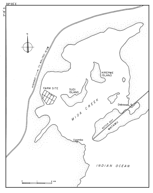
Fig. 1 - LOCATION OF THE PILOT FARM
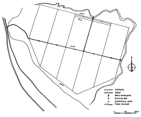
Fig. 2 - LAYOUT OF THE PILOT FARM
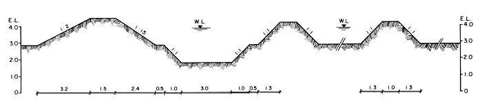
Fig. 3 - DIKE FACING THE RIVER AND NURSERY POND A - A
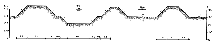
Fig. 4 - ROAD, MAIN CANAL AND DIKE FACING HIGH LAND B - B
ALL MEASURES IN METRES
![]()