![]()
![]()
![]()
Egypt is facing an increasing demand for water from multiple sectors at the time supply is fully used. Supply-side solutions are hard to find. Concerns with shortage are aggravated by serious problems regarding water pollution and salinity, calling for an integrated water management approach.
The Integrated Irrigation Improvement and Management Project is among the first of its kind in Egypt, although it still carries "irrigation" prominently in its name, this study was implemented to discover the extent the DrainFrame approach could help the IIIMP become fully integrated, both in its design and implementation. The present study follows the DrainFrame approach in analysing the functions, values, and stakeholders of natural resources in particular water in the study area, namely the Mahmoudia command area (MCA). As far as possible the stakeholders were involved in the analysis and presented a number of issues related to water management.
The exercise started with the identification of four landscapes in the command area: alluvial land, reclaimed lake bottom, irrigation canal system and the drainage system. An inventory was made of the possible (water) interactions between the upstream neighbouring land and the command area. It turned out that these interactions can be defined as boundary conditions to the MCA. Interactions can be quantified at the water intake from the Rosetta branch and drainage flows from the upstream command areas. Downstream, the MCA borders the coastal zone, where there are important fishery activities, vegetable growing and natural lakes (Edku). Since drainage effluent enters these landscapes, they are heavily influenced by water management practices in the command area.
Following identification of landscapes, their most important water-related functions were identified and briefly described. Some quantitative information was obtained on agriculture and fisheries. Clearly, much work still needs to be done in this respect. However, the main functions identified by this analysis are agricultural production; settlement; fish production; water distribution for irrigation and domestic use; water evacuation from agricultural land and settlements. Other functions include the land's capacity to maintain a groundwater and salt balance; to prevent saltwater intrusion; and for open water to purify and transport pollution. Stakeholders were easily identified. It should be noted that there are often conflicts of interest between users of different water functions, but even more so between stakeholders of the same function. The best known conflict of interest over water is that between farmers in the head reaches of canals and in the tail-end.
Once the mapping of landscapes, functions and stakeholders was complete, a problem and opportunity analysis was made of the most important functions. The following results were obtained:
Agricultural productivity: Although the yields of the main crops are rather high, there is still scope for improvement. In general, agronomic impulses are considered more promising than water management improvements. More emphasis should be placed on improvement of the net benefits per unit of irrigation water than on improvement of net benefits per unit of land area. The costs of irrigation can be lowered.
|
Jan Hoevenaars, Natural Resources Management
Specialist, Consultant |
It is believed that more efficient water use at the field level does not necessarily lead to higher overall water benefits throughout the study area, including the downstream areas, the issue deserves further investigation. Greater potential may be found in a more equitable water distribution between head and tail-end reaches. To achieve this, new stakeholder institutions (water user associations and water boards) are required.
Maintaining water quality: The losses from impaired water quality are considerable, mainly in terms of poor health conditions. In the study area, irrigation and drainage water is polluted by domestic sewage, solid waste and agro-chemicals. In the lower reaches, industrial point pollution is widespread. The irrigation and drainage systems are affected by uncontrolled waste dumping. However, the responsible sectoral organizations have no mandate to clean up the mess. There is a clear need for an integrated approach to this problem, with the involvement of important stakeholder groups.
Irrigation efficiency, water reuse and net drainage outflow: These three components of the MCA's water balance are interconnected and water quality is determined by these three factors. A study is needed to consolidate the present knowledge on these matters and identify needs for further research. Currently, much emphasis is placed on efficiency and reuse in irrigation circles to increase the amount of available Nile water for horizontal expansion. The beneficial use that is made of drainage water in downstream landscapes (fisheries, control of saltwater intrusion, vegetable growing) is not often recognized, although there is significant potential for development.
Maintenance of ecological processes and biological diversity: this function has been dramatically eroded in the lower delta and coastal zone. The function, when active, generally contributes much to human life-support systems that have potential for tourism and recreation activities.
Consequently, the critical review of the main activity components of IIIMP give rise to the following observations and recommendations:
Integrated water management requires stakeholder involvement in the planning and decisionmaking process. The drain framework indicates where and how stakeholders can play their role. In IIIMP, a start has been made with water user associations and water boards. IIIMP should seek multi-stakeholder representation especially with respect to water boards.
The investment components of IIIMP are not detailed in the Project Concept Document (PCD). It is recommended that the technical solutions to the diversity of irrigation and drainage in the MCA be fine tuned, in participatory planning sessions with the stakeholders of water (not only agricultural). Water related needs, other than irrigation, should be given due consideration.
It is recommended that environmental management plans are made an integral part of the planning and design processes at the mesqa, branch and main command level. The DrainFrame approach offers many opportunities for realization of this objective.
As regards on-farm demonstration plans, it is recommended that they be combined with agronomic improvements. The intended use of the saved water should be clearly communicated to farmers. In addition, an attempt should be made to include on-farm demonstrations of improved multifunctional water use at the mesqa level.
The EIA study can take advantage of the DrainFrame approach and the results as used in this study.
The main conclusion of this working paper is that the DrainFrame approach (possibly to be renamed the WaterFrame approach), provides an excellent framework, both conceptually and practically, for the development of integrated water resources management in Egypt. There is still need for further improvement of the practical tools, computational models and methodologies to integrate institutional aspects attached to the framework. IIIMP can take advantage of the framework to achieve its main objectives; and IIIMP offers a unique opportunity to make the framework operational.
It is well known, that throughout history Egypt has depended on the Nile for its economic and social survival. However, in recent years, population growth and economic development have placed the water system under increased pressure. Egypt already consumes more water than the Nile brings into the country, indicating that water is being reused. Today, only 12.5 billion cubic metres (BCM) annually of Nile water reaches the Mediterranean.
The known limitations of water resources, combined with an increasingly complex, multi-sectoral use of water, create problems for water management institutions organized into sectors. Interventions, carried out for the enhancement of water use in one sector, will inevitably lead to impacts in other sectors. Agricultural, industrial and domestic water use requires cautious water quantity management. Moreover, water quality management becomes an increasingly urgent necessity. Uncontrolled dumping of industrial and domestic sewage and solid waste into the drainage system increasingly limits the reuse of drainage water. Salinity, from leaching of agricultural lands and the intrusion of salininity into the groundwater from the sea further complicates the management of water resources in the Nile Delta.
The above-mentioned problems are well known and recognized among water management authorities. However, no mechanism is in place yet that would effectively integrate the various uses and users of water and their responsible authorities. According to EEAA (2000), "policy-making in Egypt is largely based on a sectoral approach. This has resulted in fragmented policies with little understanding of the interrelationship between issues. With the absence of an adequate framework for coordination and prioritization, environmental decision-making is, to a large extent, highly political and crisis driven."
Various pilot activities are being implemented that more or less address the above-mentioned water-related issues. From the viewpoint of water end-users one of the most relevant initiatives is the establishment of water boards at the branch canal level and their extension into district water boards. From the Government's perspective, an important opportunity is presented by the Integrated Irrigation Improvement and Management Project to enhance integrated water resources management.
The project further builds on the experiences of the Irrigation Improvement Project and Drainage Project, which is organized into sectors and aimed at increasing water efficiency and equitable sharing of water through improvement of the supply of irrigation water. The aim is to enhance soil productivity through introduction of sub-surface drainage. It is evident that a more integrated approach is required to address water resources management issues effectively. For example, irrigation improvement may not always address the most urgent water-related problems such as water pollution and reallocation of water among the different stakeholders. In addition, there is a need to observe the effects of such activities on other sectors depending on water.
A possible mechanism for the identification of water management issues and how to address these in an integrated manner is provided by the DrainFrame approach. This analytical tool for participatory water resources management planning was developed by the World Bank, based on experiences in the drainage sector of six countries. Although drainage has been emphasized in this study, the inherent approach is on creating a tool to manage natural resources, which may also be applied throughout the entire water resources management sector.
In this report, the tool is redefined in such a way that it may be used as a practical interventionplanning tool for the IIIMP project.
The DrainFrame methodology was developed from the perspective of drainage. However, the methodology is geared towards natural resources planning in general. Consequently, it may also be applied to water resources management, including irrigation, drainage and other water resources related activities. Therefore the word DrainFrame could be replaced by WaterFrame, thus providing a short name for an integrated analytical framework for water resources management.
DrainFrame combines:
theory and practical experience in environmental and social impact assessment that allows for systematic and comprehensive analysis of the effects and impacts of interventions in natural resources, and
recently developed views on natural resources management planning, taking an area oriented and participatory approach.
Central to the methodology is the integrated analysis of water resources management issues, from an area perspective. This implies that interventions should be based on a sound analysis of problems and opportunities in an area, and not based on a predefined type of intervention (for example irrigation improvement). Water resources management needs will differ between geographic areas. WaterFrame provides the tool to identify these needs from a stakeholder's perspective. It further provides the means of identifying the type of institutional arrangements necessary to address these issues and consequently of identifying potential institutional or organizational gaps. Figure B.1.1 shows the sequence of steps that should be followed for a systematic analysis of the consequences of water management interventions.
Figure B.1.1 Iterative analyses of (proposed) water management interventions

Source: Abdel-Dayem et al., 2004
The study team decided to select one command area in the western Nile Delta as an example of how to apply the DrainFrame approach practically. The objective of the exercise was threefold to:
analyse the functions and values of the water resources system in an integrated manner to arrive at an overview of water resources management issues that need to be addressed and for which priorities must be defined (in this study intervention priorities have not been defined although some suggestions are made);
test the practical usefulness of the DrainFrame approach; and
provide recommendations on the potential use of the DrainFrame approach for the IIIMP project.
All aspects will be dealt with in this report. The scope will be to provide an overall picture of the situation, and detail those issues that will not be covered by the other experts in the mission team.
The focus of this study is the command area of the Mahmoudia main canal, being one of the areas in which IIIMP interventions will take place. Taking an integrated perspective on natural resources management, one should pay attention to other areas that are influenced by, or will influence the effects of interventions in the Mahmoudia command area. Ultimately, the management of the entire Nile system, up to the operational rules of the Aswan High Dam, could be taken into account. Since this is beyond the scope of this study, a selection has been made of those areas that directly interact with the MCA through water flows. Upstream boundary conditions for the analysis are presented by the availability of water in the Rosetta branch; the design capacity of the Mahmoudia canal; the quality of the irrigation water entering the system and drainage water quantity and quality entering the MCA from upstream irrigation command areas such as the Nuberia old new lands.
Since drainage water flows to downstream areas beyond the boundaries of the MCA, an analysis had to be made where the boundary was drawn for the downstream effects of interventions in the Mahmoudia area. Therefore, the first exercise in the study was to select the provisional boundaries of the study area, based on expert judgement. The boundary starts at the Mahmoudia intake on Rosetta branch with the ATF pumping station and covers the entire area served by the canal (305 000 feddans). The intake of the Alexandria water treatment plant is the downstream boundary of the irrigation system. Upstream areas that directly deliver their surface drainage water and/or groundwater to MCA were included to analyse the importance of these water flows for the MCA. The downstream areas that receive drainage water from the MCA via Abu Kbeer, Muheit Edku, Atf, Shereshra and Umum drains include the coastal zone: the coastal lakes Edku and Maryut, the dune strip and finally the Mediterranean. To repeat, the Mediterranean Sea is the source of saltwater intrusion into the lowest parts of the study area and will be reported on in this study.
The first step towards an integrated view of water management problems and opportunities in and around the project area is to make an inventory of relevant landscapes and their functions. The DrainFrame concept identifies these landscapes at three levels of aggregation (see Box B.1.2). The same has been done here in the wider context of integrated water management.
Box B.1.1 BEHEIRA socio-economic profile
|
Administrative structure (structure of the Ministry of Interior)
Area
Population density: (Average) 697 capita/km2
Industrial activities |
||
|
Industrial establishments |
Number |
Average percent |
|
Chemical industry |
20 |
5.24 |
|
Construction materials |
56 |
14.66 |
|
Metal industry |
0 |
0.00 |
|
Engineering industry |
54 |
14.14 |
|
Xylose products |
35 |
9.16 |
|
Textile industry |
62 |
16.23 |
|
Paper industry |
8 |
2.09 |
|
Food industry |
144 |
37.70 |
|
Other |
3 |
0.79 |
|
Total number of industrial establishments: 382 Health care
Infrastructure
|
||
EGYPT Governorates InfoHighway (data 1997): www.highway.idsc.gov.eg/govern/BEH.htm
Figure B.1.2 Sketch of the study area

Box B.1.2 Analysis levels of natural resources landscapes
|
As stated, drainage types and typologies can be described at several levels of aggregation, serving different purposes. Three levels of analysis can be defined.
|
Source: Reclaiming drainage: Toward an integrated approach (Abdel-Dayem S. et al., 2004)
Table B.1.1 presents the hydro-ecological zones, landscapes and sub-landscapes and water management systems that were identified over several rounds. The first round involved the consultation of studies, maps, informed people and the expert's own judgment. In the second round, modifications and refinements were made upon a field visit and consultation with identified stakeholders. The hydroecological regions are important to link-up with broader water management policies that may differ considerably. The main landscapes in Table B.1.1 are listed in terms of uniformity of their resources and functions. The third level is a sub-division of the second level and takes water management systems and practices as the main characteristic.
Table B.1.1 Overview of landscapes in the study area
|
Hydro-ecological Regions |
Main landscapes |
Sub-landscapes and water management systems |
|
New land |
New-new-land |
Nuberia command and sub-commands |
|
Nile Delta |
Low deltaic old land |
Rosetta branch and levees
Drainage system
|
|
Coastal zone |
Lagoon area |
Lake Edku |
|
|
Dunes |
Dunes |
|
Large urban areas |
|
Water treatment intake and wastewater outlets |
|
Mediterranean |
Mediterranean |
Mediterranean |
Overview
This section describes in some detail the landscapes and sub-landscapes/water-management systems. The descriptions include the most important functions (goods and services) delivered by these landscapes, the main stakeholders in the functions, and the values attached to these functions by the various stakeholders or by Egyptian society as a whole. The fact that "functions" are varied in nature (see Box B.1.3) makes this complex. Especially when it comes to the quantification of the "goods and services" delivered, often there is a need to select some relevant proxy parameters as a measure for the amounts delivered.
Box B.1.3 Environmental functions - the supply of goods and services
|
From: Reclaiming Drainage: Toward an Integrated Approach (Abdel-Dayem et al., 2004) Nature provides many functions, representing goods and services that humans can exploit. Four categories of environmental functions can be identified: Processing and regulation functions: These functions relate to the maintenance of life support systems on Earth and are often not recognized until they are disturbed. Examples linked to drainage are buffering of flood peaks in wetland systems, recharge of groundwater reservoirs by infiltration, recycling of organic matter and pollutants as a natural water cleaning mechanism. Examples also include maintenance of migration and nursery habitats for fish, maintenance of biological diversity, trapping of sediments in floodplains, regulation of fresh and saltwater balance in estuaries, river mouths, coastal aquifers and regulation of biological control mechanisms. Carrying functions: The availability of space together with a particular set of environmental conditions associated with that space make an area suitable for performing certain functions for nature or humans. Examples include suitability of an area for human habitation and settlement, waterways for navigation, sites for energy conversion (e.g. hydropower reservoirs) sites for recreational activities. Production functions are goods that are produced by nature and for which people need to invest time and energy to harvest (natural production functions), or biological products (animal or plant) produced in ways that involve active management and inputs by people (nature based human production functions). Examples: soil productivity for cultivation of crops, water as a harvestable resource, fisheries, animal husbandry, aquaculture, timber, firewood, etc. Significance functions: nature provides opportunities for spiritual enrichment, cognitive development and recreation. Examples: aesthetic information (scenery, landscape), spiritual and religious information (religious sites, emotional attachment), historic information (historic and archaeological elements), cultural and artistic information (inspiration for folklore, music, dance, art), educational and scientific information (natural science classes, research, environmental indicators), etc. |
Source: adapted from R.S. de Groot (1991)
The quantification of agricultural goods, i.e. annual crop yields delivered by agricultural land is relatively easy to do. The same holds for fish production, which can be expressed in fifitonnes/feddan. It is, however, more difficult to create a single expression for the processing function of water for natural purification. Depending on the case of analysis at hand, one may decide to select one or two quantifiable parameters, such as the BOD and the turbidity of water bodies. For a carrying function, such as navigation, a parameter such as water depth and breadth may be combined with the distance of the waterway without any cross obstruction; or the maximum size of ships that may use the waterway.
The value of these functions needs to be expressed in economic, social and environmental terms. The economic value is simply to express tradeable goods in financial terms. Again, for social and environmental values, one has to rely on a few proxy parameters.
Table B.1.2a and B.1.2b give an overview of the most important landscapes, functions and stakeholders in the study area. The last columns are an expression of the shortages of supply as compared to the demand for the function. They are, in fact, a preliminary indication of issues connected to water management in the study area. The following sections provide a narrative elaboration of these functions and values using the sequence shown in the above-mentioned tables.
Table B.1.2a An overview of the Mahmoudia command area: Relevant landscapes, their functions and stakeholders
| |
Landscapes |
Functions |
Stakeholders |
Issues |
|
Mahmoudia command |
||||
|
1 |
Alluvial land |
Irrigated mixed farming |
- Agricultural sector |
Low farm income |
|
Rice cultivation |
- Rice cultivators |
High water consumption |
||
|
Animal production |
|
|
||
|
Settlement |
- Households |
Loss of agricultural land |
||
|
Maintenance of groundwater and salt balances |
- Farmers |
Threat of waterlogging and salinization |
||
|
2 |
Reclaimed lake bottom |
Irrigated mixed farming |
- Agricultural sector |
Low fertility; low income |
|
Rice cultivation |
- Rice cultivators |
High water consumption |
||
|
Animal production |
- Farmers |
|
||
|
Settlement |
- Households |
|
||
|
Maintenance of groundwater and salt balances |
- Farmers |
Threat of waterlogging and salinization |
||
|
3 |
Irrigation canal system |
Conveyance and distribution of irrigation water for command area |
- Agricultural sector |
Inequity of water supply |
|
Mixing and diluting reuse water |
- Downstream agriculture |
Low water quality |
||
|
Domestic and industrial water supply |
- Households and industries |
Water quality; shortage |
||
|
Solid waste dumping and transport |
- Households and industries |
Pollution; flow obstruction |
||
|
Sewage transport and sedimentation |
- Households and industries |
Pollution; flow obstruction |
||
|
Natural purification of water |
- All users |
|
||
|
Navigation |
- Transport sector |
Water depth; obstructions |
||
|
Delivery of water to Alexandria |
- Municipality of Alexandria |
Water quality; shortage |
||
|
4 |
Drainage canal system |
Collection and transport of surplus groundwater |
- Agriculture |
Maintenance of water levels in drainage canals |
|
Collection and transport of surplus rainfall |
- Agriculture |
Pumping capacity outfall drains |
||
|
Collection and transport of surplus salinity |
- Agriculture |
|
||
|
Collection and transport of solid waste |
- Households/industries |
Pollution; flow obstruction |
||
|
Collection and transport of sewage |
- Households/industries |
Pollution; flow obstruction |
||
|
Delivery of reuse water to canals |
- Agriculture |
Water quality |
||
|
Delivery of unofficial irrigation water |
- Agriculture |
Water quality; salinization |
||
|
Natural purification of water |
- All users |
|
||
|
Transmission of drainage water and salts from neighbouring commands |
- Command users |
Water quality; system |
||
|
Water-borne diseases |
- All inhabitants |
Malaria; bilharzia |
||
|
Fish and waterfowl |
- Farmers |
Public health |
||
|
Disposal of drainage water into Lake Edku and sea |
- Mahmoudia command area |
Water quality and quantity |
Table B.1.2b An overview of the neighbouring relevant landscapes, their functions and stakeholders
| |
Landscapes |
Main functions |
Stakeholders |
Issues |
|
5 |
Rosetta branch |
Delivery of Nile water |
- All users downstream |
Quantity of delivery |
| |
Delivery of water quality |
- All users downstream |
|
|
|
6 |
Old-new land |
Delivery of groundwater and salts |
- Agriculture old new land |
Waterlogging and salinity through upward seepage |
|
7 |
Umum drain |
Collection, conveyance and transport of drainage |
- Agriculture on-site |
Water quality |
|
8 |
Upstream old land commands |
Delivery of water and salts |
- Upstream farmers |
Water quantity and quality |
|
Off-site downstream |
|
- On-site farmers |
|
|
|
9 |
Downstream command |
Receiving drainage water |
- On-site agriculture |
Water quantity and quality |
|
10 |
Lake Edku |
Receiving drainage disposal |
- Fishermen |
Water quantity and quality |
|
Purification |
|
|
||
|
Sedimentation |
|
Loss of functions |
||
|
Regulation of salt water intrusion |
- Upstream agriculture |
Threat of salinization |
||
|
11 |
Fish farms |
Fish production |
Fish farmers |
Water quantity and quality |
|
12 |
Sabkha land |
Temporary surface water storage |
- Nature |
Availability of fresh water |
|
Salt sink |
|
|
||
|
Space for reclaimed land |
- Vegetable growers |
|
||
|
13 |
Dunes |
Vegetables and fructiculture |
- Vegetable/fruit growers |
|
|
Shore protection |
- State of VAR, Egypt |
|
||
|
14 |
Greater Alexandria |
Water consumption |
- Municipality |
Water quantity and quality |
|
15 |
Mediterranean |
Delivery of salt water intrusion |
- Farming community |
|
|
Coastal erosion |
- Fishermen |
|
The following sections describe most landscapes, their main bio-physical features and the relevant functions from the viewpoint of water and stakeholders. There is a rough quantification of the goods and services they provide, as far as the quantitative data could be obtained. The issues are discussed in the following section.
Landscapes in the Mahmoudia command area
Features of alluvial land and reclaimed lake bottoms
Most of the MCA consists of old alluvial land, with heavy montmorillonite clay soils, a very flat topography, generally sloping from 2 m plus msl in the south to 1 to 2 m minus msl in the lowest northwestern areas. Isolated higher spots (up to 5 m + msl) are, most likely, the remnants of old river levees and dunes, and may be found scattered throughout the command area (EGSA, 1996). In most cases these are used for settlements. Groundwater is found at shallow depths. Before the implementation of tile drainage systems, it fluctuated between 0 and 1 m below the surface (RIGW, 1986). Since EPADP installed tile drainage systems throughout most of the area the groundwater table has been lowered and fluctuates between 1 and 1.6 m below the surface. In most areas a freshwater layer overlays saline water. Towards the north, the freshwater lens becomes thinner and more saline. Waterlogging occurs locally, notably along the continuous flowing canal sections (seepage and leakage). Rainfall is significant during the winter season, and is on average 200 mm/yr near the coast; in the south of the MCA it is only 175 mm/yr (RIGW, 1986). The total Mahmoudia command area is around 122 000 hectares (305 000 feddans). Part of the area can be called the sub-landscape of reclaimed lake bottoms. These are very flat, less fertile lands and are around sea level with high groundwater tables. Farmers often add soil from elsewhere to improve the chemical and physical properties. A larger stretch of this landscape is found north of Damanhur.
Observed functions, stakeholders and values
Irrigated mixed farming and rice cultivation
The most important function of this landscape is agricultural production and a wide variety of crops is cultivated during the two main seasons, summer (May-October) and winter (November-April). All crops are irrigated or, in winter, are provided supplementary irrigation. The plots are mainly small to very small. The prevailing irrigation method is level furrow irrigation (broad and narrow) for row crops such as cotton and maize, and basin irrigation for broadcasted crops like berseem and wheat. The main crops are often intercropped with vegetables such as onions or peppers. Land levelling and furrowing is increasingly done by machine and both tractors and animals are used for land preparation. Rice cultivation is a special form of irrigated agriculture, the difference between this function and that of other forms of irrigated agriculture is that rice fields are ponded for most of the season. Rice is a summer crop, which is cultivated in rotation with other main field crops. Rice cultivation during the winter season is not possible because temperatures are too low.
The performance of the two functions from the viewpoint of water is obvious. Irrigation water must be brought in and, because of the leaching requirement of soils over irrigation and upward seepage of groundwater, the land must be drained of water. Part of the rainfall must also be drained, mainly as runoff water.

New land landscape (photo: J. Hoevenaars)
Table B.1.3 shows the attempt to quantify the agricultural goods and services in the command area. It is based on a standardized cropping pattern. Agricultural production figures in Egypt are monitored and aggregated by district and governorates. Therefore, it is not easy to compare these figures with the production of a command area.
Apart from the economic value of the products, parameters should be selected that express the social value, e.g. employment opportunities and food security, expressed as the ratio between total and locally consumed wheat production. However, no quantitative data could be found during the mission. Agriculture generates an environmental burden, which represents a negative value. If agricultural practices change, e.g. introduction of more productive varieties, which may be more vulnerable to pests, the consumption of agrochemicals is likely to increase and more residues will end up in the drainage system. So far, representative proxy indicators for the environmental burden of agriculture have not been identified.
All farmers in the area are stakeholders.
Settlements and industries
The Nile Delta is densely populated. The Beheira governorate has five million inhabitants, distributed over some urbanized areas and many rural villages and hamlets. Typically, villages are compact; if possible, they are established on elevated land or along a branch canal or mesqa. Because of the loss of agricultural land to urbanization, a recent law prevents housing development on agricultural lands. The law is enforced but violations continue to occur. The exact percentage of land used for settlement is not known and varies throughout the MCA.

Irrigation canal system (photo: J. Hoevenaars)
This function's relationships with water include settlements that are the source of solid waste and sewage enters the MCA water bodies. Settlements require drinking-water, which is almost everywhere provided by public water supply systems. Other domestic water needs are often supplied by the irrigation canals.
No further enquiries have been made into the economic and social values of settlements. The stakeholders are the five million inhabitants.
Table B.1.3 Economic value of agricultural production function (provisional fifigures)
|
Total area |
120 000 ha |
|
|
|
|
|
|
Summer crops |
Approximate percentage of total area |
Hectares cropped |
Net revenue1) |
Net return |
|
|
|
Rice |
39 |
46 841 |
2 341 |
109 633 870 |
|
|
|
Maize |
20 |
23 465 |
1 962 |
46 041 178 |
|
|
|
Cotton |
26 |
31 179 |
2 008 |
62 614 980 |
|
|
|
Winter crop |
|
|
|
|
|
|
|
Wheat |
37 |
44 715 |
2 419 |
108 175 011 |
|
|
|
Broad bean |
9 |
10 378 |
1 363 |
14 144 099 |
|
|
|
Berseem short |
31 |
37 623 |
3 308 |
124 465 118 |
|
|
|
Berseem long |
16 |
19 200 |
6 890 |
132 288 000 |
|
|
|
Total |
|
|
|
597 362 255 |
|
|
|
Summer crops |
Etcrop |
L. Req. +Losses |
50 percent re-use |
Net use |
Total use |
Net value of
water |
|
Rice |
1 200 |
400 |
200 |
14 000 |
655 774 580 |
0.17 |
|
Maize |
840 |
414 |
207 |
10 469 |
245 645 762 |
0.19 |
|
Cotton |
1 065 |
525 |
262 |
13 273 |
413 831 026 |
0.15 |
|
Winter crop |
|
|
|
|
|
|
|
Wheat |
375 |
185 |
92 |
4 674 |
208 974 885 |
0.52 |
|
Broad bean |
400 |
197 |
99 |
4 985 |
51 735 461 |
0.27 |
|
Berseem short |
400 |
197 |
99 |
4 985 |
187 554 531 |
0.66 |
|
Berseem long |
800 |
394 |
197 |
9 970 |
191 426 866 |
0.69 |
|
Total |
|
|
|
|
1 954 943 109 |
0.31 |
Source: MARL, Agricultural Affairs Sector, Agricultural Statistics, Crop Data 2003
The Mahmoudia main canal iThe is a secure source of water that has attracted a large number of industries. The canal water is used for processing and disposal of untreated polluted water back into the water system.
The produced goods per square metre or per cubic metre of water, as well as the employment density, are much higher for industries as compared to agriculture. Industries provide off-farm employment opportunities to the small-scale farmers that help them earn sufficient income.

Irrigation canal system (photo: J. Hoevenaars)
The stakeholders are the enterprises, labourers/farmers and shareholders.
Maintenance of the fresh/saline groundwater balance
An important function of the landscape is the "regulation" of the groundwater depth and its salinity levels. This is considered an important part of the function, since the saline groundwater/freshwater interface is at shallow depths in the MCA. A thorough knowledge of the groundwater dynamics is required to understand this function fully. There is an ongoing scientific debate in Egypt on the extent of saline groundwater intrusion from the sea. The saline groundwater may be of a fossil nature and may have been generated during delta formation. Time did not allow for an identification of past studies conducted on this subject. At the field level, irrigation of agricultural land in the lower delta area is required to maintain a layer of freshwater, which counteracts the influence of deeper saline groundwater. Rice plays a major role in this context and the operational policy allows for an increase in rice intensity towards the coastal region. Thus rice cropping has an environmental function.
Once the downward flow of surface water stops, the reverse takes place and the capillary action brings saline water to the plants' root zone. The net downward flow from irrigation required to keep the effect of salinity below reasonable limits, is called the "leaching requirement". Taking these requirements and the groundwater dynamics into account, subsurface drainage has been installed throughout most of the MCA. This results in a net output of salts from the soils at the cost of certain amounts of leaching water. Water boards participating in the planning and design of the systems to minimize leaching requirements have proposed modifications in the general design of the drainage systems.

Drainage canal system (photo: J. Hoevenaars)
The increasing areas cultivated with rice, in combination with subsurface drainage, have caused an increase in the local demand for water, at the expense of downstream farmers. The economic returns per hectare of rice are high and the salinity problems effectively counteracted by this culture. However, inequity of water supply is aggravated and the mixed cropping pattern makes it difficult to practice controlled drainage.

Settlement (photo: J. Hoevenaars)
Value: maintenance of soil productivity for agriculture, which maintains farmers' income levels.
Stakeholders: farmers in the lower delta
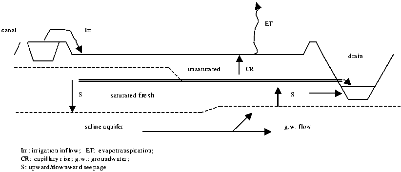
Figure B.1.3 Definition diagram of groundwater variables
The irrigation system
The Mahmoudia irrigation system is defined as a separate landscape so that specific functions may be attached to it. Many of the technical-hydraulic characteristics will not be dealt with in this section, as they will be covered in the Irrigation and Drainage specialist's report. Here the main canal and branch system is considered as a continuous water body, flowing for most of the time throughout the command area. The mesqas in the improved and unimproved areas are taken as separate sub-landscapes. Most of the improved mesqas are centrally pumped and lined canals or underground-piped distribution networks that deliver water to the open field channels or marwas. In the unimproved areas, the mesqas resemble an extension of the open main and branch canal network and are not very different in terms of their function.
The functions that do not differ in the various parts of the system are discussed first. Functions that are specific to the main and branch canals or mesqas are discussed at the respective sublevels.
Observed functions, stakeholders and value
Water conveyance and distribution
The dedicated function of the entire canal system is to receive, convey and distribute irrigation water equitably throughout the MCA. This is a regulation function that makes other functions possible, such as agricultural production, the availability of drinking and domestic water, etc. The stakeholders of this function are virtually all inhabitants of the MCA, downstream water users such as fishermen and the Alexandria municipality. The interesting features of the system are the discharge pattern along the canals (time and quantity) and water quality. Though the value of a regulating function is difficult to define, on the cost side it is clear that a substantial amount of money is needed for operation, maintenance and replacement.
Weed growth and sedimentation
Landscapes perform functions that people appreciate and those they dislike. In other words, functions may be valued positively and negatively. An open canal delivers irrigation water (positively valued) and a certain amount of sediments. Since sedimentation of a canal diminishes its capacity this represents a negative value. If these sediments are excavated by farmers to raise their land (as happens in the lake bottom landscape), or to increase its fertility, then the negative value of sedimentation may be partly or fully turned into a positive value. All the open canals are unlined or semi-lined and weed growth is, therefore, abundant. Sedimentation of solid particles takes place in certain stretches of the system, leading to a decreased conveyance capacity and a rise in water levels (heading-up). Both effects result in water shortages at the tail-ends, who are the true stakeholders of this negative function. Regular maintenance is required to allow for a sustainable and equitable performance of the irrigation system. The costs of maintenance and the loss of agricultural production due to water shortages are expressions of the value of this function.
Sewage conveyance, solid waste disposal and washing
It was assumed that use of irrigation canals for sewage and solid waste disposal would not be serious since rural farming communities depend on this water supply. Somewhat surprisingly, branch canals running through villages are becoming heavily polluted and congested with solid waste. Water quality has visibly deteriorated only a few kilometres from the inlet. Washing in canals is frequently observed; see also the description under "Drainage system". It is expected that different stakeholders will have conflicting interests, upstream and downstream, as well as between the agricultural and the housing sectors. The value of the function of sewage conveyance, solid waste disposal and washing can be expressed both in social (health) and in financial terms (cost of alternative waste and sewage management).
Domestic geese and ducks
Throughout the region's irrigation (and drainage), system large numbers of geese and ducks can be seen making use of the canals. These birds are appreciated for their eggs and meat.
Mahmoudia main canal
Water supply to branch canals
The main canal receives water from the Rosetta Nile branch through the El-Atf pumping station. The Mahmoudia canal is operated on a continuous basis. At more or less regular distances, branch canals are provided with water through controlled inlets. In areas with unimproved irrigation, gates are controlled manually and receive water in a pre-established rotation (e.g. 5 days on, 5 days off). In areas under the IIP the branch headworks are (or will be) replaced by automatic downstream level controlled gates and receive water on a continuous basis.
Supply of Alexandria drinking-water
Alexandria depends on the Mahmoudia canal for its drinking-water. There have been conflicts about water during periods of water shortage and high demand for irrigation water. Formally, drinking-water supply has top priority; because of the high demand for rice cultivation (surpassing the officially allowed proportion of rice in the area), the canal capacity is insufficient during periods of peak demand. To overcome this problem proposals have been advanced for the construction of a pipeline from the Nile to Alexandria. Inevitably, this supply-oriented solution will lead to higher water consumption since the constraint to water use is lifted.
The price per cubic metre paid by Alexandria is well below cost; inherently there is little incentive for water savings. The Alexandria drinking-water system allegedly works with unaccounted losses of around 70 percent, a demand management ruling could significantly contribute to a solution.
Value: quality of life and health of inhabitants in Alexandria; agricultural productivity in the Mahmoudia command area.
Stakeholders: 5-7 million inhabitants in the greater Alexandria area. Approximately two million people depend on agriculture as their primary livelihood.
Navigation
The Mahmoudia canal has ship locks and is connected to a larger system of waterways that are used for navigation. Very little activity was observed during the mission.
Fish (cage) culture
Fisheries in Egypt are at their limit of productivity. Attempts to meet future demand in fish must be met by fish culture. There is increased pressure on the Ministry of Water Resources and Irrigation to allow cage culture in the main irrigation canals. So far, fish culture is only allowed (by law) in drainage water. MWRI fiercely opposes the idea of cage culture in canals (this also applies to the Nile River and Lake Nasser) as it is believed that fish culture is polluting irrigation and drinking-water, and interfering with the cross-sections of the canals. According to NWRP (2002), scientific evidence for this opposing view is lacking.
Value: increased economic use of irrigation water. Fish culture is said to be a very profitable business. Consumer demand for fish is higher than what Egypt can currently provide.
Stakeholders: fish culture entrepreneurs and consumers; irrigation and drinking-water authorities.
Branch canals
Water supply to mesqas
Again, a distinction must be made between unimproved and improved irrigation situations. In the unimproved situation, water flows in the branch canals on a rotational basis. Again, some rotation is followed for the distribution of this water to the unimproved mesqas through manually controlled slide-gates. The operation is given to a ditch-rider of the Irrigation Department and delivery of water to the unimproved mesqas is below field level. In the so-called improved situation, the branch canal runs continuously. Mesqas are provided with a central pumping station for the entire downstream area, which is operated by the water user association. An important change in water delivery from the unimproved to the improved situation is the change from rotational supply to continuous supply with downstream control at the branch level. Only one or two automated gates are needed in the branch canal. Since the control over the tertiary intakes will be given to the water user associations, the water supply to the mesqas will become continuous, or at least as often as the water user associations believe good for themselves.
Water supply to drains (overflow)
Overflowing of canals into drains is considered a loss of water. However, the overflowing of canals leads to higher quality drainage water. The complete coverage of the area with a functioning drainage system, combined with reuse of drainage water, puts this perceived loss in another light. In fact, hardly any water is lost as it performs a multitude of other functions when spilled into the drainage system.
Value: increased quantity and quality of drainage water to be (re)used for multiple purposes.
Stakeholders: multiple.
Receiving water from main and secondary drains
Egypt has adopted a policy of reusing drainage water for irrigation as far as possible to add water to the total available amount. Pumping stations on the main and secondary drains lift the drainage water a few metres and dispose of it in the irrigation canals. Because of salinity and pollution, drainage water quality is less than that of irrigation water. For this reason, irrigation water quality downstream of the reuse pumping station deteriorates. In principle, there are standards for water quality and the extent to which it can be safely mixed with fresh irrigation water; here practice seems to be less strict than theory. The value of this reuse can be expressed as an incremental agricultural production minus the cost of pumping. Socially, the effect of the reuse of drainage water through mixing is that the water becomes less fit for domestic use, and has a serious impact on public health. Therefore, there is a conflict of interest between farmers and households.
Mesqas
Distribution of irrigation water
The mesqas receive water from the secondary canal and distribute it over the tertiary unit to the landholdings. In the unimproved situation, water is delivered below surface through an open and unlined mesqa. Farmers themselves pump it out of the mesqa into their marwa (field canal) and from there onto the field. There used to be little regulation of time sharing for water flow, which resulted in over irrigation in the head reaches of the mesqa and increased rice cultivation. The lower reaches are faced with serious water shortages and yield reduction. These tail-enders then often practice unofficial reuse of drainage water to cope with the situation. All-in-all there are many conflicts over water in the unimproved mesqas. The improved mesqas provide water, in most occasions through a piped underground system with alfalfa-valves, sometimes through a lined open mesqa with division boxes. The valves are freely accessible to farmers. In order to prevent inequity in water supply a WUA is given the responsibility of introducing timesharing and its supervision.
In addition, the advantage of the improved mesqas is that no further pollution takes place at this level. The only function that remains is the provision of irrigation water.
The drainage system
In comparison to the irrigation system, the drainage system is defined as a particular landscape. The status of the subsurface area of the drainage system (collector drains and laterals) is ambiguous. On the one hand it may be considered an attribute of the soil and landscape to which the soil belongs, as it partly determines the groundwater regulating function of the landscape. On the other, subsurface drainage is largely managed by the farmers and drainage maintenance staff (flushing, blocking). In the new land, upstream of the MCA, controlled drainage is becoming increasingly popular. It is for this reason that the subsurface drainage systems are defined in this study as a (sub-) landscape.
Another conceptual problem is posed by the fact that the drainage basins do not coincide with the irrigation commands and sub-commands. The Umum and Edku main drains serve the dewatering of the MCA and other large command areas. The secondary drains normally serve branch canal commands on both sides. The sub-surface drainage systems are not necessarily all within one tertiary unit. Since the DrainFrame approach always includes analysis of the neighbouring landscapes, for investigation of the impacts of certain interventions, this does not present much of a problem. The entire drainage system is considered one landscape, whether inside the MCA or partly outside it. To analyse the functions of the drainage system, a distinction is made between the open drainage system (main, secondary and tertiary open drains) and the sub-surface drainage system. Part of the functions of the open drainage system are similar in nature to those of the canal system.
Subsurface systems
The technical details of subsurface systems will be dealt with in the working paper by the Irrigation and Drainage Specialist.
Maintaining a groundwater and salt balance
The dedicated function of the subsurface drainage system, where installed, is to maintain a certain groundwater and salt balance in the fields. A network of closed collector pipes discharges effluent from a number of connected and perforated lateral pipes. The depth and spacing of the laterals, in combination with the soil properties, determine the effect of subsurface drainage. Nowadays almost the entire MCA area is provided with subsurface drainage systems. In comparison with the earlier situation, where there were only scattered open drains, waterlogging and associated salinity has been brought under control with beneficial effects to crop production. The case study on Egypt (van Achthoven et al., 2003) reports considerable increases in yield for almost all main crops, with the exception of rice. The latter is quite understandable, because rice is not much affected by waterlogging and, due to the practice of ponding freshwater on the field; a suitable freshwater micro-environment is created for the rice plants. Other sources show that rice yields have increased in saline soil areas after subsurface drainage was provided.
Apart from the increase in yields, the Egypt case study mentions a number of other effects (See Box B.1.4).
Box B.1.4 Various benefits from agricultural drainage in Egypt (Achthoven et al. 2003)
|
OTHER AGRICULTURAL BENEFITS
OTHER NON-AGRICULTURAL BENEFITS
|
It was reported in the Egypt case study that the average farm-income had improved by about US$200 per year in saline areas after the installation of subsurface drainage, and up to US$375 per year in other areas. The stakeholders are the farmers and the households living in the nearby settlements. A negative aspect is that salts and agrochemical residues now travel much faster downstream than before.
Open drains
Conveyance of subsurface drainage eff uent (including salts) and rainwater
The main function of the network of drainage canals is to convey drainage water from agricultural and residential areas to receiving water bodies. The water levels in the outfall drains, such as Masraf Umum and Edku, are below sea level, so the entire discharge must be pumped out. Drainage and pumping capacity in some areas appear to be insufficient to deal with heavy rainstorms.

Drainage construction in progress (photo: J. Hoevenaars)
Value: increased agricultural productivity result from improved drainage (as part of the entire drainage intervention package; see section on agricultural lands).
Stakeholders: farmers in the Mahmoudia command area that have improved subsurface drainage or old open field drains; inhabitants of residential areas.
Sewage conveyance
Wastewater treatment in the Beheira governorate is largely confined to the urbanized areas where eight treatment plants are operational (one of which needs rehabilitation). The governorates' priority is to rehabilitate or expand existing facilities. The sewage from approximately 70 percent of urban households is treated, before its release into drains. In rural areas, only 10 percent of household sewage is treated. The majority of households possesses storage tanks that are emptied regularly by trucks. These trucks then dump this liquid waste into the main drainage canals, thus contributing to the organic load in the canals, leading to algae development and, in extreme cases, to anoxia causing massive death of aquatic organisms. Apart from the organic pollution, the use of canals for sewage presents a danger to public health since diseases can be transmitted by this practice.
Value: The savings made on investment costs in sewage collection and treatment facilities are high. However, environmental, social and economic costs of the present situation have been calculated as higher (see next section on problems and opportunities). On a larger scale, the official policy concerning the reuse of drainage water is threatened by the decreasing water quality in the drains.
Stakeholders: all inhabitants in the study area; increasing impacts expected in a northern direction.
Washing
Public drinking-water supply covers some 95 percent of rural households. Some households still depend on groundwater wells. Nevertheless, many people still use canals and drains to wash clothes or food such as vegetables (as observed during the field visit). Diarrhoeal diseases are among the most serious causes of child mortality. According to the National Water Research Center (NWRC, 2001) a correlation with the following factors has been scientifically established: disposal services, water supply, water quality and water collection. Open water continues to be used because the storage capacity of sewage tanks is limited and washing of clothes contributes to the rapid filling of tanks. Using canals to wash vegetables is a habit that should be strongly discouraged.
Some water boards have taken the initiative to create so-called "water clubs", specially designed public areas with safe water supply for washing. In some cases, the allocation of land and investment for construction in these areas appears to be problematic. The environmental committees of a few water boards, usually comprised of women, are involved in awareness-raising activities and communal cleaning activities.
Value: cost of emptying of sewage tanks causes people to use open water. The impact on public health is serious.
Stakeholders: inhabitants of rural villages.
Solid waste disposal
In most rural, as well as urban communities, solid household waste is dumped on the banks of canals and drains, where it ultimately causes serious water pollution and obstruction of water flow. Organic waste contributes to the high organic content of water and anoxic conditions; non-degradable plastics cause drainage congestion.
Value: Maintenance cost of drainage canals increases because of the practice of dumping solid waste. Downstream users of drainage water suffer from decreased flow and/or decreased water quality.
Stakeholders: inhabitants of the entire area who dump waste and, at the same time, depend on the water resources of the Nile Delta. Conflicting interests between upstream and downstream stakeholders.
Official reuse for irrigation
A number of mixing stations pump drainage water back into the irrigation canals. Drainage water, with relatively high salinity, is mixed with irrigation water of higher quality. Drainage water thus can be reused for irrigation. Six mixing stations in the Nile Delta had to be closed (one on the Mahmoudia main canal) because of low water quality and its threat to the intake of drinking-water further downstream in the irrigation canals. The government is planning to implement a policy on intermediate reuse, emphasizing the recycling of water at points upstream of significant pollution discharges to reduce the problem of cross-contamination and accumulation of pollutants.
Values: agricultural productivity is significantly increased by the reuse of irrigation water. Water quality problems at the inlet of drinking-water facilities lead to health hazards and/or increased treatment costs. Food products may become polluted.
Stakeholders: farmers downstream of the mixing station receiving an increased amount of irrigation water; industrial and drinking-water agencies downstream of the mixing stations, notably Alexandria municipality.
Unofficial reuse for irrigation
Tail-end farmers are often obliged to pump water from drains to irrigate their fields, because of uneven distribution of irrigation water along the branch canals and mesqas. It is estimated that unofficial reuse amounts to 50 percent of the total reuse of drainage water in the delta (DRI/SC-DLO, 1995). One of the main objectives of the Irrigation Improvement Project is to enhance the equitable distribution of water along mesqas in order to prevent social problems caused by unequal distribution. If successful, this intervention may influence unofficial reuse considerably.
Value: agricultural productivity maintained in case of water shortage.
Stakeholders: tail-end farmers throughout the delta, increasing in a northern direction in the lower delta area.
Water provision to downstream landscape
Drainage water of the Mahmoudia area is conveyed to Lakes Edku and Maryut or directly to the Mediterranean Sea. The official policy is to increase water use efficiency in the agricultural areas in the delta by introducing improved irrigation techniques and reuse of drainage water. The result of this policy, if successful, is that the amount of drainage water will be reduced, though the concentration of salts and pollutants will increase, thus threatening the livelihoods of stakeholders depending on drainage water.
Values and stakeholders: As described under "Downstream neighbouring landscapes" in this report: "Coastal lakes" and "Coastal ridge" the entire fisheries and fish-farming community depends on drainage water as well as a large proportion of farmers in the lower reaches of the delta.
Breeding of bilharzia vector snail
Drains are good breeding sites for freshwater snails that transmit bilharzia (schistosomiasis), a parasitic disease that leads to serious illness at high levels of infection. During the field visits, vector snails of both vesicle (urinary) and intestinal bilharzia were observed in large numbers. Infection risk correlates with the availability of household water supply, reducing the need to be in contact with open water (National Water Research Center, 2001). In the past bilharzia was an enormous public health problem in Egypt. Nowadays, an effective primary health care infrastructure and improved public water supply have contributed enormously to control of the disease. Subsurface drainage has contributed substantially in reducing the number of suitable breeding places.
Value: health risk to (predominantly) rural people is still present, but at a level that can be controlled by the primary health care service. Cost of treatment and days lost in labour.
Stakeholders: all people in contact with water. Professionally: farmers, household work, mainly women and children.
Navigation
The main drains are suitable for navigation. However, the only movement of boats observed during the field visit was to ferry people across the drain. In most cases culverts, low bridges and pipelines crossing the drains make them unfit for navigation. The economics of transportation is beyond the scope of this report; apparently road transport is less costly (or more efficient) than water transport.
Self-cleaning capacity
Reportedly, natural processes in the drains contribute significantly to the reduction of the organic pollution load.
Upstream neighbouring landscapes
There is no need to describe and analyse the upstream landscapes in detail. It is better that the relationship between water quantity and quality exchange in these landscapes and the MCA are understood. It is not expected that interventions in the MCA will significantly affect upstream landscapes. If water management interventions are to be evaluated on a wider scale, obviously these landscapes should be analysed in more detail.
Rosetta branch and river levees
The Rosetta branch delivers water to the Mahmoudia command area through the El-Atf pumping station. The dedicated share of water for the MCA is decided upon at the national level. All downstream inhabitants are stakeholders of this function. The river levees bordering the Rosetta branch have little interaction with the MCA and are thus left out of this analysis. Water quality in the Rosetta branch is a factor as it impacts the functions of the landscapes downstream. The Rosetta branch receives excessive loads of municipal and industrial wastewater.
Upstream old land command areas
Another command area borders the MCA to the south. This area delivers surface drainage water, salts, and groundwater to the MCA landscapes. The amount of re-usable surface drainage water is particularly important to agricultural production in the command area and downstream landscapes.
Nuberia old new land
The southwestern and western neighbouring landscape is formed by the old-new-land that comes under the Nuberia irrigation command. The divide is formed by the Umum and Shereshera drainage system. Initially the irrigation of these old-new-lands created problems of upward seepage, waterlogging and salinity on the old land. These problems have been taken care of by the construction of interceptor drains and the installation of subsurface drainage; otherwise, there is not much hydrological interaction between the MCA and this landscape.
Downstream neighbouring landscapes
Interaction between the MCA and the downstream landscapes is more important, since the effects of interventions in natural resources travel downstream much easier than upstream.
Coastal lakes: Open water and reed lands
Prevention of seawater intrusion
After the coastal ridge, the lakes present the second line of defence against the intrusion of underground seawater. At present, it is not certain how salinity in the Nile Delta is governed. One school of thought stresses the importance of seawater intruding into the underground beneath a layer of freshwater maintained by the lakes and irrigated lands. Another school insists on the historical character of the soil salinity and denies the significant present influence of the Mediterranean[11].
Value: There is insufficient scientific evidence to support either one of these schools of thought. Therefore, it is impossible to describe the actual value of the lakes' contribution to preventing intrusion of salinity.
Stakeholders: farmers in the lower Nile Delta.
Storage of drainage water
The seasonality of the lakes' temporary brackish and freshwater conditions has changed with the constant inflow of nutrient rich freshwater from the main drains. Although the lakes are shallow (0.5-1.5 m deep), the surface area of 27 470 feddans (11 446 ha) for Lake Edku and 16 240 feddans (6 767 ha) for Lake Maryut represent a significant water storage facility (very roughly estimated at 114.5 + 67.7 = 182.2 million m3). The high nutrient load in the drainage water (sewage and fertilizers) combined with the change in character arising from seasonal brackish and freshwater conditions to almost permanent freshwater, has resulted in the proliferation of reeds, papyrus and floating aquatic weeds (water hyacinth, potamogeton). This in turn leads to increased silting up of the lakes and obstruction to navigation and fishing.
Lake Edku has an opening to the sea (boughaz) near Maadiya, maintaining a minimal part of its original ecological character. The flow through the boughaz is determined by the balance between seawater level and drainage inflow, evapotranspiration of lake and marshes, rainfall and intrusion into the underground. Seawater may flow in or lake water may flow out. Its surface area has significantly decreased as a result of land reclamation: from 35 770 feddans in 1953 and 28 480 feddans in 1973 to 27 470 feddans in 1981. Lake Edku receives its water from the Bersik (south) and Edku drains (east). Chains of islands compartmentalize the lake. The salinity level ranges between 1 and 5 g/litre. Evaporation amounts to 1 440 mm/year (= approximately 5 m3/s for the entire lake).
Lake Maryut has lost 48 percent of its surface area to reclamation for agriculture, from 32 160 feddans in 1950 (1955: 31 370 feddans, 1973: 16 280 feddans) to 16 240 feddans in 1981. The lake's water sources are the Umum drain, 74 m3/s (agriculture), and the Qalaa drain (mixed wastewater 0.7 million m3/day). The lake has no sea connection; this may have caused large sections to exhibit anoxic conditions, producing badly smelling hydrogen-sulphuric gases, which make the area unsuitable for residential settlement. Because of the lack of exchange with the open sea, the lake acts as an evaporation pan, where organic and chemical pollutants concentrate.
Value: it is difficult to establish the use made of the water stored in the lakes. Although it was observed that vegetable growing, fruit orchards and fish farming is common around the lakes.
Stakeholders: (fish) farmers around the lake.
Discharge of industrial and urban liquid waste
Together with Lake Manzala, Lake Maryut is defined as a black area in Egypt's environmental action plan. It is an alarming example of pollution in Egypt. The greater Alexandria area represents 35 percent of Egypt's national industry, with over 1 000 industrial units. Liquid waste, amounting to 1 million m3 per day, is discharged into Lake Maryut, in drains or at sea. Lake Edku does not receive similar quantities of industrial waste.
Value: Lake Maryut has become unsuitable for fish farming, it constitutes a potential health hazard (quality of consumed fish, hydrogen sulphide gases, diseases), is unsuitable for recreational activities (Alexandria), and the nuisance created by odours and mosquitoes makes the surrounding land unsuitable for residential development.
Stakeholders: inhabitants of greater Alexandria area (7 million).
Fisheries production
National fish production in Egypt was calculated in 1998 at 545 593 tonnes. Fisheries represented 406 204 tonnes, fish culture 139 389 tonnes. The northern lakes combined represent some 30 percent of national fish production. Lakes Edku and Maryut represent respectively 1.9 percent and 0.8 percent of this total.
Mullet-based brackish water fisheries have been replaced by tilapia-based freshwater fisheries. In spite of dramatic changes in water quality and composition of fish species, the total catch in Lake Edku has, between 1985 and 1998, increased from 6 600 tonnes to 10 280 tonnes. This indicates that the agricultural and residential nutrient loads, carried by the drains into the lake, are effectively converted into fish mass. A yearly fisheries productivity of up to 900 fifififikg/ha (375 kg/feddan, see Table B.1.4) for freshwater bodies is high. Scarce available data on levels of pesticides in water and fish tissue appear to indicate that these pollutants do not pose a public health concern in Lake Edku. However, NWRP (2000) states that there are considerable differences in opinion concerning the amounts of toxicants in water and fish. They vary from heavy pollution to no pollution and available data on laboratory analysis of fish tissue point in both directions, which is sufficient reason for serious concern.
Reed development is a constraint to fisheries. In Lake Maryut broad sections must be cleared of the reeds to maintain part of its fisheries potential.
A peculiarity of Lake Edku is the collection of juvenile eels at the boughaz. Eels migrate from the open sea, their birthplace, to inland waters to mature. Captured juvenile eels are transferred to fish ponds for further growth. Thus far it has been impossible to reproduce eels in captivity.
In Lake Maryut total fish catch strongly fluctuates from year to year with a high of 7 700 tonnes in 1985 and a low of 1 900 tonnes in 1995. The last available data from 1998 show that fisheries have partially been restored at 4 521 tonnes. The fluctuations are caused by serious environmental degradation of the lake resulting from industrial and urban pollution and its closed nature, which prevents incidental flushing.
Fish from Lake Maryut are considered a potential health hazard because of the accumulation of poisonous elements in the fish tissue.
Table B.1.4 Overview of fish productivity in coastal areas
|
Lake |
Surface |
Fish production |
Productivity |
Number of boats* |
Catch |
|
Edku |
27 470 |
10 280 |
375 |
1 619 |
17.0 |
|
Maryut |
16 240 |
4 521 |
278 |
2 458 |
6.6 |
* A boat is operated by three fishermen (National Water Research Center, Strategic Research Unit, MWRI, 2001).
Value: On average a fishing boat on Lake Edku catches 17 tonnes yearly. The freshwater tilapias are considered of lower value compared to brackish water mullets. For this reason, an expansion of seawater by, for example, enlarging the outlet to the sea would probably lead to increased income levels.
A boat is operated by three fishermen in total 4 857 persons are directly employed in fisheries on Lake Edku. Figures are unavailable for indirect employment in processing and marketing. The situation around Lake Maryut is less favourable. Yearly catch per boat is 6.6 tonnes. Some 7 344 persons are directly involved in fisheries.
Stakeholders: directly some 12 000 fishermen; indirectly the intermediary traders and ultimately the consumers benefiting from an affordable source of protein. Consumption level of fish is estimated at 10 kg per person per year. At present Egypt is almost self-sufficient in fish. Communities such as Edku largely depend on fisheries and related activities for their economic survival.
Water purification and reed production
As stated earlier, freshwater conditions and high nutrient loads have led to a proliferation of emergent reeds, which are being used on a small-scale for the production of mats, used to protect gardens or plantations. This use is insignificant in relation to the amount of reeds produced by the lakes. Reeds are known to absorb large quantities of salts and nutrients. Regular harvesting of reeds in shifts, and the removal of organic matter, can contribute to an improvement in water quality and fish productivity.
Value: the production potential of reeds is limited. Better economic use of reeds, combined with its additional value for water quality improvement should receive more attention.
Stakeholders: fishermen benefit from reed removal; water quality is an issue of national concern.
Breeding of nuisance pests
The permanent freshwater character of the lakes has created good breeding conditions for bilharzia vector snails. Freshwater conditions, in combination with proliferation of weeds, has created ideal breeding conditions for mosquitoes, creating a significant nuisance to residents.
Value: increased health risk to those working in or with water. Nuisance caused by mosquitoes contributes to unfavourable conditions in the area for development of residential or recreational facilities, especially around Lake Maryut.
Stakeholders: Alexandria, with its 7 million inhabitants, is in great need of expansion of residential and recreational areas.
Maintenance of biological diversity and processes
The coastal lakes were known to be areas of high species diversity, both aquatic species and birds. As described above, biological resources still represent significant value in terms of fisheries revenues and water quality improvement. However, the conservation of biological diversity has not received any attention. The area is heavily influenced by human interventions. Plant diversity has been reduced by the spread of reeds and water hyacinth. Observations in the area did not reveal significant numbers of waterfowl. The coastal lagoons are known to be important wintering areas for waterfowl from Northern Europe, but there is no information on their present status. Available information from the Nile River suggests that fish diversity has decreased significantly. Of the 47 species of commercially caught species that used to inhabit the Nile, only 17 remain today. This will almost certainly apply to Lakes Edku and Maryut. As these lakes have no special legal status and information was not readily available, no further inquiries have been made on this subject.
Value: maintenance of biological processes.
Stakeholders: future generations.
Coastal lakes: fish ponds
Fish culture
Along the Nile, fish culture goes back to the earliest civilization. Present day pond culture began to expand in the 1960s and 1970s. Fish culture production has risen from 12 400 tonnes in 1977 to 139 300 tonnes in 1998, representing 25.5 percent of total national fish production. This includes fish farms, cage culture, grass carp stocking programmes, rice-fish farming. Tilapia and carp (in rice) are the most common. Only hatcheries are allowed in freshwater and fish farms in drainage water.
A large proportion of Lake Edku has been reclaimed for agriculture. The high salinity of the soils rendered it unsuitable for sustained agricultural practice and in several areas; this land has been converted into fish ponds. A 1 400 feddan fish farm (operated by Mr Sabry Belal) was visited. The farm uses drainage water to produce tilapia, silver carp and eels. Ponds are fertilized with manure (chicken, cattle), thus creating a nutrient rich environment to develop phytoplankton and zooplankton on which fish live. Agricultural residues such as rice and wheat bran are used as an additional source of fish food. Because of the relatively extensive farming, there is no need to apply chemicals or disease controlling agents. On a yearly basis ponds are dried and residues excavated.
A typical pond measures 10 feddan and is stocked with 6 000 fish from the nursery. The stocked fish grow in one year from 20 g to a marketable size of about 250 g. Most produce is marketed in Alexandria.
The farm started operating in 1982. In the 22 years of existence, there has been no occurrence of low water quality or quantity from the drainage canal. Therefore, the farm is operating sustainably, completely based on the reuse of drainage water from the Mahmoudia command area.
Values: Beheira governorate produced 8 075 tonnes of cultivated fish in 1995. The average production of the visited farm is 2 tonnes/feddan/year, which is mainly based on low input tilapia farming. The land is leased from the government at LE 100/feddan/year; annual revenues from fish amount to LE 6 000/ feddan/year. The farm provides employment to 300 people. From the viewpoint of landscape aesthetics, fish farming activities are devastating as they create a large-scale treeless landscape of ponds and dykes. Continuous dredging of ponds and dumping of sludge hinders the development of vegetation. Opinions will vary depending on individual aesthetic appreciation of a landscape.
Stakeholders: private enterprises in fish farming, employees and consumers (mainly in the Alexandria area). The present level of 10 kg of fish per capita cannot be maintained by fisheries; any increase in demand for fish must come from imported fish or in increased aquaculture.
Groundwater
There are no exact data on the effects of fish farming on groundwater. It is expected that a 1 400 feddan farm with 1.5 m of water will contribute to the maintenance of a freshwater layer on top of the saline groundwater. Even though the drainage water has relatively high salinity, it will be far less than the underlying saline water.
Coastal lakes: reclaimed/abandoned land
Plantation: vegetables and fruit
Efforts to reclaim the lake for agriculture have been halted because of the high salinity of soil and groundwater. Today, a significant proportion of the reclaimed agricultural lands have been abandoned. However, the mission visited a site where saline land has been raised with light, sandy soil; drainage water was used to irrigate (drip irrigation) a mixed plantation of highly productive fruit trees and vegetables. Such landfills can be observed scattered over the area.
Value: One plantation visited (owned by Mr Belal) of 4 feddan provided employment to ten labourers. (Figures are available from Scheumann).
Stakeholders: farmers, investors, employees
Coastal ridge/dunes
Along the Mediterranean coast, a sandy ridge separates the sea from the inland lakes. The observed functions of these landscapes were:
Coastal defence
The seaward side of the ridge consists of low sandy dunes (up to a maximum of 10 m high).
Value: the Mediterranean coast is subject to occasional severe winter storms; the dunes protect the hinterland from potential flooding.
Stakeholders: inhabitants of the coastal zone and agricultural hinterland.
Collection of rainwater
Rainfall along the Mediterranean coast amounts to approximately 200 mm per year.
Value: The coastal ridge is the first line of defence against the intrusion of seawater and provides suitable local conditions for plantation agriculture.
Stakeholders: lower delta farmers.
Plantations
The dunes have largely been levelled and planted with mixed date palms and guava trees. To achieve this, the top of the dunes was deposited into lower depressions, where seawater intrusion had created saline conditions unsuitable for cultivation. The plantations are irrigated with drainage water from Lake Edku.
Value: around 5 million date palms have been planted between the city of Edku and Alexandria.
Stakeholders: large-scale farmers (owned or leased).
Infrastructure
Sections of the coastal highways are built on the coastal ridge.
Mediterranean
In a complete analysis, the influence of water resources management on the Mediterranean should be incorporated into the study (in consideration of the effects on coastal fisheries and pollution of beaches). Given the complexity of the issues and the limited time available, this was considered beyond the scope of the mission. However, data from written sources (WQMU, 2003 and a tourist guide) suggest that the coastline east of Alexandria suffers from significant pollution and has become unsuitable for recreational activities. Quality and quantity of fish in coastal waters will be affected by resource management practices in the study area; consequently, marine fisheries are a stakeholder in the entire picture. These issues are documented (NWRP, 2000).
|
[11] Detailed hydrologic
studies were made by RIGW that favour the first school of thought, though the
other possibility is still not completely abandoned, as became clear from
discussions. The case for locked fossil salt groundwater of marine origin was
demonstrated in the Senegal river delta by Audibert (1970). |
![]()
![]()
![]()