![]()
![]()
![]()
Restricted distribution
| UNITED NATIONS DEVELOPMENT PROGRAMME FOOD AND AGRICULTURE ORGANIZATION OF THE UNITED NATIONS | GOVERNMENT OF KENYA MINISTRY OF ENVIRONMENT AND NATURAL RESOURCES |
| FISHERIES DEPARTMENT: COAST PROVINCE | PROJECT KEN/74/023 “OFFSHORE TRAWLING SURVEY” |
Work Report No. 8
THE STOCK ASSESSMENT OF THE KENYAN DEMERSAL OFFSHORE RESOURCES, SURVEYED IN THE PERIOD 1979–1980–1981
Mombasa, January 1982
SUMMARY
From February 1979 until June 1981 the trawler R/V “UJUZI” surveyed the offshore Kenyan waters. The results of this vessel, supplemented by the results of three other trawlers, have been used for this stock assessment. The method used is the “swept-area method”. A three-level stratification has been applied to all data (twelve fishing-grounds, two monsoon-periods, fifteen groups of species).
For the total trawlable surface of 3234 nm2 (see charts 3 and 2), the total standing stock amounts to approximately 33,000 ton, the maximum sustainable yield is approximately 9,000 ton (the totals of Table 4 plus the “KUSI-area” plus the “MESYATSEV-area”). About half of these quantities consists of small fishes without any commercial value. The densities vary from 4.5 ton/nm2 (“MESYATSEV-area”) to 25.2 ton/nm2 (stratum I). The results show further that, compared with other parts of the world, the productivity of the offshore demersal resources of Kenya is very low.
A simple feasibility-study for each defined sub-area is added, showing that offshore trawling in Kenya is not profitable.
1. INTRODUCTION
One of the objectives of project KEN/74/023 was to survey the offshore waters off Kenya and gather information about composition, distribution and magnitude of the fishery resources. This report will try to give a quantitative analysis of the trawlable resources, which have been surveyed by the project's vessel R/V “UJUZI” from February 1979 until June 1981.
To supplement the results of this survey, the findings of the research vessel “DR. FRIDTJOF NANSEN” have been incorporated in the stock assessment. This vessel visited the Kenyan waters in 1980 during the month of December.
Furthermore, some additional data collected by the survey vessel “PROFESSOR MESYATSEV” (irregular sampling from December 1975 to NOVEMBER 1977) and the commercial trawler M/V “KUSI” (January 1978-March 1979) have been used.
2. DESCRIPTION OF THE AREA (see chart 1)
The Kenyan waters can be divided roughly into four parts; 1) the North Kenya Bank, 2) the area off Ungama Bay, 3) the Malindi Bank and 4) the area between the Malindi Bank and Pemba Island.
The North Kenya Bank has a hard bottom, mostly corals. Great numbers of large sponges do occur, and here the big commercial fishes like Lutjanidae, Pomadasyidae, Lethrinidae and Serranidae can be found.
Off Ungama Bay, the situation is more complex. A rather narrow strip is formed by the 10 to 100 fathoms depth lines. The southern part of this strip is under the influence of the Sabaki river, especially during rainy periods. The yellow/brown coloured water of this river, mixed with the seawater, flows to the north (due to the East African Coastal Current) and can be seen up to Ras Ngomeni. The bottom of the narrow strip off Ungama Bay consists mostly of sand, the characteristic fishes of this area are the semi-pelagic and pelagic species like Leiognathus, Gerres and Carangoides in the southern part and sharks and rays in the northern part. The deeper waters off Ungama Bay have a more muddy bottom, where lobsters and shrimps can be caught.
South of Malindi is the Malindi Bank, of which very little is known, except that it is almost completely untrawlable.
The area between Malindi Bank and Pemba Island has a very steep depth-gradient near the coast. The bottom is sometimes rocky, but most of it is mud. Deeper than 100 fathoms small amounts of non-commercial deep-sea fishes occur. Only near Pemba Island some shrimps can be caught.
3. THE WIND
Two monsoon-periods can be distinguished, the southeast monsoon (March till October) and the northeast monsoon (November-February). The wind-force during the northeast monsoon is usually less than during the southeast monsoon. During every haul R/V “UJUZI” made, the direction and strength of the wind was measured. The results are shown in Fig. 1.
4. THE CURRENTS
The main current off the coast of Kenya is the East African Coastal Current, which flows northwards. During the southeast monsoon, the wind reinforces the current and gives the water a speed up to 5 knots. During the north-east monsoon the wind is against the current and in the northern part of Kenya a southward flowing stream appears, the so-called Somalian Current. This current reaches in the end of the northeast monsoon (February) to the area off Malindi. South of Malindi the current remains to flow northwards. There are a few places where some turbulence is present throughout the year; near Pemba Island, near Malindi (off Sabaki river) and in the northern part of the deeper waters off Ugama Bay.
For a more detailed description of the currents, see Anon. (1981 d).
5. THE DATA
For the stock assessment, the following records have been used:
6. GENERAL DESCRIPTION OF THE METHOD USED
The usual technique for the estimation of potential yield is the analysis of the data of catch and effort of commercial trawling. These data are not present in Kenya, so the data of exploratory fishing vessels have been used. With this, a rough estimate of the biomass of fishes that can be caught by trawling, can be made. With some knowlege about the biological and ecological characteristics of the species it is possible to give an estimate of the yearly production that can be obtained from that biomass, without the risk of the depletion of the stock.
6.1. Calculation of biomass
The result of a haul is considered to be representative for the biomass of fishes, present in the volume of water that passes the net. Therefore, it is necessary to know the vertical and horizontal opening of the net and the distance covered by the net during the time of the haul.
But the distribution of the fishes on the bottom is not homogeneous; the fishes are more or less grouped into schools. Repetition of hauls under the same conditions in the same area gives results which are very different.
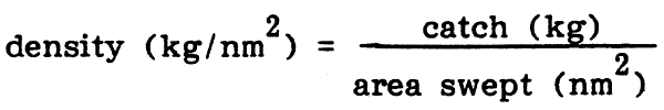
In order to cope with this heterogeneous distribution, a number of hauls should be made at random in an area, which is supported to be more or less homogeneous. In practice it is generally assumed that in each homogeneous area at least thirty hauls are necessary (Saville, 1977). For each haul, the density of fishes can be calculated in kilogrammes per square nautical mile (kg/nm2). The mean of all these densities gives an estimate of the density of the population within the homogeneous area. Thus the estimation of the trawlable biomass of a homogeneous area is the product of the mean density by the trawlable surface of that area.
6.2. Calculation of potential yield
The trawlable fish resources in the deeper waters have not been exploited so far, except by two large trawlers: M/V "“KUSI” (during one year in a very restricted area) and the “AEGINA” (during five weeks in another very restricted area). Therefore the stock can be considered as virgin. It has been demonstrated and proved by experience that, as a first approach, the relation between the biomass of a virgin stock (BO) and the maximum sustainable yield (MSY) can be very simply translated by the formula:
MSY = 0.5 · BO · M
where M stands for the natural mortality rate of the stock.
7. DETAILED DESCRIPTION OF THE METHOD USED
7.1. Definition of trawlable areas
First of all, the trawlable and non-trawlable grounds have been defined. For this, data of “DR. FRIDTJOF NANSEN”, the data of R/V “UJUZI” and the experience of the staff of the project have been used. The result is plotted on chart 2. As criterion for the definition of the trawlable grounds the capacity of R/V “UJUZI” with the available gears has been taken.
7.2. Three level stratification
(This applies to the data of R/V “UJUZI2 and of “DR. FRIDTJOF NANSEN”, some results of the M/V “KUSI” and the “PROFESSOR MESYATSEV” are presented separate in chapter 9 and chapter 10 respectively).
It was necessary to make a three level stratification because of:
the heterogenity of the grounds (coral, sand mud; hard, soft; even, uneven) and the heterogenity in density of observations
the heterogenity of the seasons (NE and SE monsoon)
the heterogenity of the species composition in the catches
7.2.1. The homogeneous areas (species composition, environmental conditions) have been defined. The result is shown on chart 3, descriptions of the defined areas are listed below.
North Kenya Bank: North boundary: 01°39' South. The area is enclosed by the 10 and 100 fathoms depth lines. In the south, between the 10 and 20 fathoms depth lines, the boarder has been defined 02°36' South, rectangular on the dpeth gradient. Between 20 and 100 fathoms the boarder is 02°48' South, rectangular on the depth gradient.
Stratum I: Is situated between the 10 and 100 fathoms depth lines. The boundaries in the north are as described above. In the south between 10 and 20 fathoms, the area ends at 03°04' South (rectangular on the depth-gradient) and between 20 and 100 fathoms at 03°01' South, rectangular on the depth-gradient.
Stratum II: Between 10 and 20 fathoms; northern boundary described above, south-boundary 03°13' South, rectangular on the depth-gradient.
Stratum III: Between 20 and 100 fathoms; north-boundary described in stratum I, south-boundary 03°15' South, rectangular on the depth-gradient.
Stratum IV: In the northeast the boundary is the 100 fathoms depth line. The northern point is at o2°47' South, the southern point at 03°00' South, the western point at 40°25' East, the two eastern points at 40°34' East.
Stratum V: Between the 100 and 200 fathoms lines; in the north the boundary is the North Kenya Bank and the line on 40°46'East. In the South the boarder is 03°26' and the line from 03°16' South 40°13' East to 03°26' South 40°16'5” East. This area does not include stratum IV. Furthermore a part of the “KUSI-area” (description below) has to be deducted.
“KUSI-area”: A rectangle, the four corners are:
| 03°04'S | 40°31'E |
| 03°05'S | 40°34'E |
| 03°15'5''S | 40°26'5''E |
| 03°18'5''S | 40°29'5''E |
Stratum VI: The boundaries in the northeast are the 200 fathoms line and the “KUSI-area”. In the East the line 40°46', in the South 03°26'.
Malindi Bank: In the north the boarders are as described in II, III and V. In the west the boundary is the 10 fathoms line, in the east 40°17' East. In the south the 03°43' line and the line 03°22', 40°02' and 03°43', 40°11'.
Malindi Bank - Pemba Island: Boundaries in the north; described above. In the west the 10 fathoms-line. In the east the line between 03°43', 40°11' and 04°42', 39°48'. In the south the line on 04°42'. From this area a part should be deducted, that is the part taken by ‘Pemba Island’, see below.
Pemba Island: Defined by the four points:
| 04°36'S | 39°39'5"E |
| 04°36'S | 39°54'E |
| 04°42'S | 39°36'E |
| 04°42'S | 39°54'E |
“MESYATSEV”-area: Defined by the four points:
| 04°42'S | 39°36'E |
| 04°42'S | 39°54'E |
| 04°47'S | 39°32'5"E |
| 04°47'S | 39°54'E |
7.2.2. All the data have been split into two groups; those collected during the southeast monsoon, and those collected during the northeast monsoon (for the definitions of the monsoons, see Fig. 1)
7.2.3. Because of the large heterogenity of the fishes caught, it was practically impossible to calculate the biomass and potential yield for every single species. Therefore the fishes have been grouped into fifteen categories, taking into account their economic value as well as their estimated natural mortality rate (see annex 4). The latter should be more or less equal for each species within each group, as the calculation of the maximum sustainable yield uses this natural mortality rate.
7.3. Swept areas
For each separate haul, the area swept by the net was calculated (“Working sheet no. 1”, see annex 5). The swept area is the product of the distance covered by the net on the bottom and the distance between the wings. For R/V “UJUZI”, the latter has been provided by the captain, the former has been extracted from the haul records in three different ways, in order of preference and with a percentage, indicating how often it has been applied:
For “DR. FRIDTJOF NANSEN”, there was no data on the wingspread of the net available. But the R/V “UJUZI” and “DR. FRIDTJOF NANSEN” carried out “comparative fishing”, and the calculated correction factor for “DR. FRIDTJOF NANSEN” (see 7.5.) has been based on the assumption that the wingspread of the net of “DR. FRIDTJOF NANSEN” was equal to that of the High Opening Fish cum Shrimp trawl of R/V “UJUZI”, that is 0.0091 nm.
7.4. The use of different nets
R/V “UJUZI” has used several nets, the High Opening Fish cum Shrimp trawl (HOFS), the Lobster trawl, the Balloon trawl and the Beam trawl.
The results of the Beam trawl have not been incorporated in this report for three main reasons:
this trawl has only been used during two trips
compared with the Balloon trawl, the HOFS and the Lobster trawl, the rigging of the Beam trawl was very different
for unknown reasons, the catches of the Beam trawl have always been very poor (the polishing of the shoes indicated that the trawl was working properly).
As the mesh-sizes of the three remaining nets differed from each other and the size of the nets also, there was need for a correction of the results of these three nets. Because of the availability of only one vessel, “comparative fishing” could not be carried out. To solve this problem, the three nets have been compared two by two. The comparison between HOFS and the Lobster trawl is given in Table 1. For each stratum and for each type of net, the total area swept and total catch is given. With these figures, an average density has been calculated, without the use of any correction factor:
The quotient of each pair of densities gives as result, the number of times ine net catches more than the other. Because the number of hauls that were made in each stratum vary, an “overall mean correction-factor” for HOFS/ Lobster has been calculated by giving each factor per stratum a certain “weight”, that is the lowest number of hauls made in that stratum by one type of net. The result of HOFS/Lobster is 2.4/1. Similar tables for HOFS/Balloon and Lobster/Balloon gave respectively 7.7/1 and 2.5/1. The correction-factor for HOFS/Lobster seemed to be appropriate, as the Lobster trawl has a wider mesg-size in the cod-end and as it is smaller than the HOFS. But the poor results of the Balloon trawl are strange, as the Balloon trawl has more or less the same size as the HOFS. An explanation for this could be that the Balloon trawl (always used with bobbins) was too heavy for R/V “UJUZI”, an assumption also made by the captain. For these reasons, the results of the Balloon trawl have not been used in this report.
7.5. Comparative fishing between R/V “UJUZI” and “DR.FRIDTJOF NANSEN”
The two vessels have done 7 hauls side by side. The results, grouped into the 15 groups of species, are shown in Table 2. Because of lack of data on the wingspread of the bottom trawl of “DR. FRIDTJOF NANSEN” the net used by “DR.FRIDTJOF NANSEN” was assumed to be similar to that of R/V “UJUZI”, and linear regression was applied on the catches of both vessels. This means that any difference between the nets is already incorporated in the correction factors found. Viewing the results, an overall correction factor of 1.2 has been applied for the results of “DR.FRIDTJOF NANSEN”.
7.6. Calculation of densities
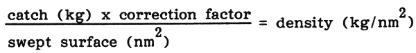
For each stratum, “Working sheet no.2” (see annex 6) has been completed. The swept surface has been taken from “Working sheet no.1”. The correction factors for the Lobster trawl and the trawl of “DR.FRIDTJOF NANSEN” have been calculated in 7.4. and 7.5.
Each catch has been divided into the 15 groups of species. For each group the density has been calculated:
For this calculation, the efficiency of the net has been assumed to be 100%. Some factors that can influence this percentage are:
7.7. Calculation of biomass
For each group of species, “Working sheet no. 3” (see annex 7) has been completed.
The trawlable surface of each stratum has been defined by drawing the area on chalkpaper, cutting and weighing this. Comparison with the weight of a ‘standard-piece’ of chalkpaper revealed the surface. The total and trawlable surfaces of each stratum are listed in Table 3.
The total number of hauls, the average density and the confidence limits have been calculated from the data on “Working sheet no. 2”, according to the formula:
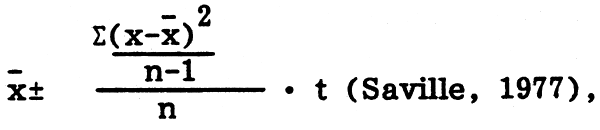
| where | n | stands for the number of hauls |
| x | stands for the density per haul | |
| x | stands for the mean density per stratum | |
| t | stands for the student's value |
(95% confidence limits, the number of degrees of freedom is n-1).
The confidence limits have been expressed as a percentage of the mean density. The mean density and the trawlable surface give the estimated biomass per stratum (expressed in metric tons) while the calculated confidence limits and biomass give the minimum and maximum estimates of that biomass.
7.8. Calculation of maximum sustainable yield (MSY)
According to the formula MSY = 0.5 . Bo . M (see 6.2.) the MSY has been calculated for each stratum for each group of species (see Table 4). The biomass has been copied from “Working sheet no.3”, and for each group of species a natural mortality rate was estimated. In the calculation the mean of the two values listed in Table 5 has been applied.
| Type of net | Wingspread (nm) |
| Lobster trawl | 0.0077 |
| HOFS (1979) | 0.0106 |
| HOFS (1980) | 0.0091 |
| HOFS (1981) | 0.0087 |
As the wingspread depends on the speed of the net through the water, which was varying considerably due to the changing currents, this can cause some inaccuracy.
The distance covered by the net over the bottom had to be calculated in 33% of all hauls from the estimated/observed directions and speeds of the vessel and the current, and the duration of the haul. The calculations with these estimations are not as precise as when the distance covered was measured by using radar and recorded during the haul and/or could be calculated from the recorded start- and end position of the vessel (also by using radar).
The comparison between the HOFS and Lobster trawl had to be done in an anusual way. It would have been better to compare the results of both nets for each different group, like it was done for “DR. FRIDTJOF NANSEN” versus R/V “UJUZI”. This because the HOFS is a much higher net than the Lobster trawl so that for example for the semi-pelagic fishes (=“small commercial fishes”) a different correction-factor is likely to be found than for small demersal fishes (=“small non-commercial fishes”). But the results of this detailed comparison were not satisfying: HOFS/Lobster gave for small demersal fishes 3.6/1, whilst for small semi-pelagic fishes 2.0/1 was found.
The biomass has been calculated based on the trawlable grounds, which are flat in comparison with the non-trawlable areas. It is very likely that the composition and density of fishes in the non-trawlable areas differ from those in the trawlable areas, so in order to get the biomass for the total area, the estimated biomass for trawlable areas can not simply be raised by the quotient total area/trawlable area.
The lumping of all fish-species into 15 groups was inevitable but as a result the calculation of MSY's had to be based on more or less rough estimates of the natural mortality rates for each group as a whole.
9. THE“KUSI”-AREA
The “KUSI”, a 40 m large trawler, tried to operate off the Kenyan coast on a commercial base for the period of one year. In “voyage 13” the “KUSI” discovered what in this report is called the “KUSI-area”. The last three voyages of the “KUSI” (15, 16 and 17) went again to this area.
The results of these cruises are listed below:
| Trip no. | Period | Type of net | No- of hauls | Mean density prawns (kg/nm2) | Mean density lobster (kg/nm2) |
| 15 | NE monsoon | Shrimp Bottom Trawl | 29 | 720 | 244 |
| 16 | NE monsoon | Beam Trawl | 22 | 3362 | - |
| 17 | SE monsoon | Beam Trawl | 27 | 5540 | - |
For the calculation of the densities the data in the logbook of the captain have been used (annex 3). The wingspread of the Shrimp Bottom Trawl has been estimated from the construction of the trawl (0.0023 nm). The total “wingspread” of the two Beam Trawls was 2 × 10.5 = 21 meters (0.011 nm). The results are a bit strange, especially the differences between the results of the Shrimp Bottom Trawl and the Beam Trawls. The calculated biomass and MSY are listed below:
| Mean density (ton/nm2) | Biomass (ton) | MSY (ton) | |
| Prawns | 3.2 | 144 | 108 |
| Lobster | 0.1 | 5 | 2 |
| Total | 3.3 | 149 | 110 |
The “KUSI” could only operate with great losses (de Boer and Hoogenraad 1979). Only the last trip (of which the high density of 5.5 ton shrimps/nm2 has been derived) made some profit. The area is just like stratum IV with its lobsters, very small (45 nm2) and fishing without the depletion of the stock will only be possible for a very limited period.
10. THE“MESYATSEV-area”
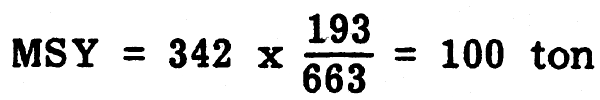
The vessel made 9 hauls north of Pemba Island, here called “MESYATSEV-area” The trawl that the “PROFESSOR MESYATSEV” used had a wingspread of 16.4 meters, 0.0089 nm. The mean catch per mile trawled was 40 kg, thus the density is 4494 kg/nm2. As the trawlable surface of the “MESYATSEV-area” is 76 nm2, the biomass amounts to 342 ton. If we assume that the catch composition of “Pemba Island” equals that of the “MESYATSEV-area”, the relation between biomass and MSY of “Pemba Island” (Table 4) can be applied:
11. DISCUSSION OF THE RESULTS BY STREAM
The average densities for each group of species for each stratum are shown in Table 6.
On the North Kenya Bank the snappers, grunters, groupers and emperors are of relatively great importance (46%). The high figure for the crabs can be explained by some incidental catches of schools of swimming crabs (Portunidae), up to 800 kg/hour.
In stratum I, the high density of sharks and rays is striking but the result is based on 7 hauls only. Still the “PROFESSOR MESYATSEV” found that in the same area the sharks and rays were of relative great importance (Birkett, 1979).
In stratum II the small commercial fishes form half of the total density. Here the “jumbo-shrimps” can be caught (0.3 ton/nm2). Unfortunately there are no data on the area between the coast and west-boarder of stratum II, where small commercial shrimpers operate.
The division of stratum III in northeast monsoon and southeast monsoon shows that in the southeast monsoon the density of almost every group of species is higher than in the northeast monsoon. The composition of the catch remains remarkably constant. The “small commercial fishes” and Pamamba and Chana are the most important.
Like in stratum III, the mean densities of stratum IV in the south east monsoon are higher than those in the northeast monsoon. Like in stratum III, the composition remains constant, with one exception: Lobster (mainly Puerulus angulatus), which has an average density of 1.4 ton/nm2 in the northeast monsoon and 5 ton/nm2 in the southeast monsoon.
A report on the survey of“PROFESSOR MESYATSEV” (VNIRO, 1978) already indicated a possible explanation for this phenomenon; seasonal migration between waters of 210–230 meters in the southeast monsoon and waters of 260–300 meters in the northeast monsoon. However, R/V “UJUZI” only found lobsters in waters of 230–289 meters depth; in the northeast monsoon 230–289 meters; in the southeast monsoon 243–280 meters.
The number of hauls in stratum V was too low for a presentation of the results with northeast and southeast monsoon separated. But for lobsters, the mean density for V - northeast is 773 kg/nm2 (22 hauls and for V - southeast 2099 kg/nm2 (15 hauls plus one semi-commercial haul in which only the catches of shrimps (mainly Heterocarpus woodmasoni) and lobsters (mainly Puerulus angulatus) were recorded). Thus migration of lobsters from stratum IV towards stratum V in the northeast monsoon does not seem to be likely. If migration does not occur, the difference found in stratum IV might be “artefact”: for a similar density of population, the efficiency of gear and/or the availability of the lobster to the gear are different.
The cause for the differences between northeast and southeast monsoon could be the current: for the strata IV and V, the current in the northeast monsoon flows to the south and during the southeast monsoon to the north.
The "small non-commercial fishes form half of the total density in stratum V. Shrimps become more abundant (6% of the total density) while on the other hand the amount of lobsters decreases.
In stratum VI again half of the total density is formed by“small non-commercial fishes” while the tendency of the increasing amount of shrimps and decreasing amount of lobsters continues.
In the “KUSI-area” the lobsters are almost absent and the biomass of crustaceans consits almost completely of shrimps. The densitities of shrimps and lobsters in the strata IV, V and VI and the “KUSI-area” are plotted in Fig. 2.
In “Malindi Bank - Pemba Island” 71% of the total density consists of “small non-commercial fishes”. The total density is low, 7.7 ton/nm2.
In “Pemba Island”, the total density of 7.1 ton/nm2 is even lower. Here some shrimps have been found (0.6 ton/nm2).
The “MESYATSEV-area” has the lowest density of all strata: 4.5 ton/ nm2. However, this result is based on 9 hauls only.
12. JUDGING THE MAXIMUM SUSTAINABLE YIELD
In tropical ecosystems on a continental shelf the yields per unit area are very similar all over the world (Poinsard, pers. comm.);
More than 35 ton/nm2 in estuaria and very shallow waters
Between 15 and 30 ton/nm2 on reefs and rather shallow waters (down to approximately 40 fathoms)
Less than 15 ton/nm2 in waters, between 40 and 80 fathoms
The results of the survey of R/V “UJUZI” are (from Table 4):
| AREA, STRATUM | MSY (ton/nm2) | DEPTH (fathoms) |
| North Kenya Bank | 2.6 | 10–200 |
| I | 3.7 | 10–100 |
| II | 4.6 | 10–20 |
| III | 4.4 | 20–100 |
| IV | 6.3 | 130–160 |
| V | 3.5 | 100–200 |
| VI | 3.7 | 200–400 |
| KUSI-area* | 2.4 | 190–220 |
| Malindi Bank - Pemba Island | 2.2 | 10–430 |
| Pemba Island | 2.1 | 200–300 |
| MESYATSEV-area | 1.3 | 50–200 |
As most of the strata are deeper than 80 fathoms, comparison is difficult. Stratum I and III (two of the “richer”strata of the survey) are far below the observed productivity in other parts of the world. The yield of stratum II (4.6 ton/nm2) is particularly low compared with 15–30 ton/nm2. The very low productivity of the Kenyan waters off the coral reefs can be explained by:
the coral reef and the area inside the reefs take alomost all the inland output as far as nutrients are concerned
the waters off Kenya are a zone of oceanic convergence. The masses of water transported by the surface-currents towards the Kenyan coast deviate to below. This is the contrary of “upwelling”: nutritive salts are washed away, the primary production is low and the overall productivity is low.
13. FEASIBILITY OF TRAWLING
13.1. Assumptions
The assumption has been made that the R/V “UJUZI” fishes according to the scheme below, with Mombasa as home-port.
| Day 1 | : | Preparations, loading ice, food, water, fuel. |
| Night 1–2 | : | Journey to fishing grounds. |
| Day No. 2–7 | : | Fishing. Commercial trips of R/V “UJUZI” learned that during favourable weather trawling can be done for 6 hours; 3 hours are spent on winch operations, cleaning and repairing the nets; 3 hours steaming is necessary to trawl from/to the fishing grounds for anchorage during the night. |
| Night 7–8 | : | Journey to Mombasa. |
| Day No. 8 | : | Unloadind fish, maintainance. |
| Day No. 9 | : | Rest. |
With this scheme, 40 trips/year can be made. It is assumed that the net used is the HOFS, at a bottom speed of 3nm/h.
Furthermore it is assumed that the total fishing effort within each stratum/ area, corresponds with MSY/MNEY. In Fig. 3, the relations between fishing effort and total costs of fishing, value of the total catch, net economic yield and value of the catch per unit effort are plotted. In general, these curves are the observed results of the different kind of mathematical models (Garcia and Le Reste, 1981). Two levels of fishing effort are of special interest:
The value of the total catch is at a maximum (the total catch is at a maximum, MSY).
The net economic yield is at a maximum (MNEY).
Depending on the objectives of the management of the stock, the optimum level of fishing-effort will be at a level corresponding to MSY or MNEY. For this report, the important result of this graph is that the (value of) the catch per unit effort, that corresponds to MSY or MNEY is (roughly) half the catch per unit effort in the “virgin stock”, that is, the catch per unit effort corresponding to a level of fishing-effort which is nearly zero. This factor 0.5 will be used for the calculation of the value of the total catch (13.3).
13.2. Costs (see Table 7).
The calculation of the costs has been based on the actual costs of R/V “UJUZI” during its operation as far as fuel costs, operational costs and service costs are concerned. The salaries have been estimated.
13.3. Revenue
The calculation of the value of the total catch (see Table 7) has been done as follows. After one hour trawling with the R/V “UJUZI” and the High Opening Fish cum Shrimp trawl the average catch to be expected in each stratum/area is the product of the wingspread of HOFS (0.0091 nm) by the distance covered by the net (3 nm) by the average density within that stratum/area (kg/nm2 see Table 6) by 0.5 (see 13.1.). The value of the catch has been calculated according to the current prices observed on the Mombasa fish market and in the main processing units (see Table 8). The predicted catches and their total value are listed in Table 9.
13.3. Discussion
The result of this simple approach (Table 7) show already that offshore trawling in Kenya is not profitable. One area seems to be an exception, that is stratum IV. The area is only very small (66 nm2) and with an average density of lobster of 0.5 ton/nm2 (SE monsoon data), a biomass of 330 ton, a MSY of 140 ton/year and an average catch rate of 68 kg/hour, the fishing-effort of one vessel similar to R/V “UJUZI” corresponds already almost to the MSY (40 trips × 6 fishing-days × 6 fishing-hours × 68 kg lobster per hour is a yearly total catch of lobster of 98 ton).
However, the practice has proven that even trawling in stratum IV is not viable. The “AEGINA” (the only offshore operating trawler observed during the project) has been fishing in stratum IV. After five weeks the vessel stopped the operations and went again to the very shallow waters at the boarder of Ungama Bay. The reasons to abandon these fishing-grounds were: too little catch and the large risk of loosing/damaging the nets, this because the lobsters are accumulated at the bottom of a rather steep rocky slope.
REFERENCES
Anon. (1981a). Work-report no.1. Survey activities in 1979.
Anon. (1981b). Work-report no.2. Survey activities in 1980.
Anon. (1981c). Work-report no.3. Survey activities in 1981.
Anon. (1981d). Work-report no.4. Surface current movements of Kenya offshore waters observed during the survey period 1979–1981.
Anon. (1981e). Work-report no.5. Biological observations and analyses during the survey period 1979–1981.
Anon. (1981f). Work-report no.6. Line fishing during the survey period 1979–1981.
Anon. (1981g). Work-report no.7. Biological data, analyses and catch records of Pomadasys opercularis, Drepane punctata and Lobster.
Birket, L. (1979). Tech.Rep. Indian Ocean Programme, (26): 97 p. Western Indian Ocean fishery resources survey. Report on the cruises of R/V “PROFESSOR MESYATSEV”, December 1975-June 1976/July 1977-December 1977.
de Boer, E.J. and Hoogenraad, J. (1979). Report of the findings of Dutch organisations and experts involved in the deep-sea fishery project Kenya.
Garcia, S. and L. Le Reste (1981). Life cycles, dynamics, exploitation and management of coastal penaeid shrimp stocks. FAO Fish.Tech.Pap., (203): 215 P.
Saville, A. (1977). FAO Fish.Tech.Pap., (171): 76 p. Survey methods of appraising fishery resources.
Vniro (1978). Western Indian Ocean fisheries resources survey FAO/UNDP/ U.S.S.R. cooperative project. Indian Ocean Programme, Development Report no-46.
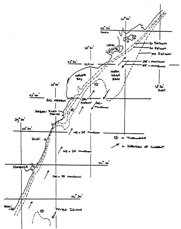
Chart 1. Currents during the SE-Monsoon and NE-Monsoon.
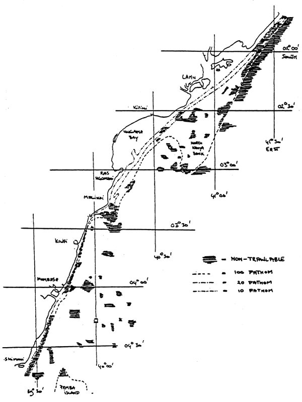
Chart 2. Trawlable and non-trawlable grounds.
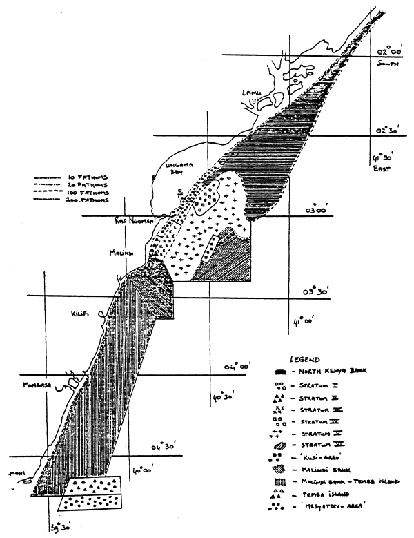
Chart 3. Definition of the areas.
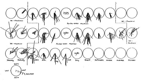
Figure 1. Direction and strength of the wind, recorded at the trawl stations in 1979, 1980, 1981 and the definition of the Monsoons.
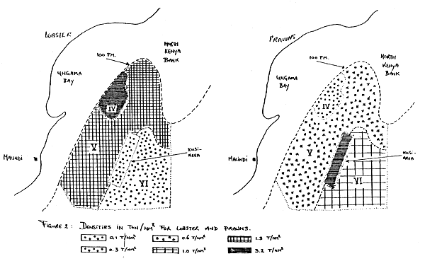
Figure 2. Densities in tonnes/nm2 for lobster and prawns.
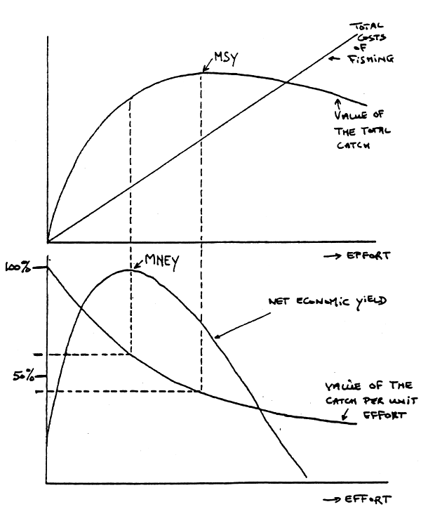
Figure 3. Relation between effort and total costs of fishing, value of the total catch, net economic yield (= value of the total catch minus total costs of fishing) and value of the catch per unit effort (after Garcia and Le Reste, 1981).
Table 1. Comparison between the HOFS trawl and the Lobster trawl.
| Area | Monsoon | Type of net | No of hauls | Total area swept (nm2) | Total catch (kg) | Density (kg/nm2) | Factor |
| NK | NE | HOFS | 10 | 0.1626 | 2120.28 | 13040 | |
| NK | NE | Lobster | 13 | 0.2563 | 925.67 | 3612 | 3.61 |
| I(1) | SE | HOFS | 1 | 0.0594 | 1999.80 | 33667 | |
| I(1) | SE | Lobster | 2 | 0.0494 | 1144.30 | 23164 | 1.45+ |
| II | NE | HOFS | 10 | 0.4142 | 5006.30 | 12087 | |
| II | NE | Lobster | 2 | 0.0365 | 432.20 | 11841 | 1.02 |
| III | NE | HOFS | 37 | 1.4108 | 18752.45 | 13292 | |
| III | NE | Lobster | 7 | 0.3261 | 2174.53 | 6668 | 1.99 |
| III | SE | HOFS | 53 | 2.1748 | 41104.70 | 18900 | |
| III | SE | Lobster | 7 | 0.2152 | 1021.89 | 4749 | 3.98 |
| IV | SE | HOFS | 13 | 0.4412 | 4949.02 | 11217 | |
| IV | SE | Lobster | 14 | 0.5861 | 5763.12 | 9833 | 1.14 |
| V(1) | SE | HOFS | 2 | 0.0616 | 1937.93 | 31460 | |
| V(1) | SE | Lobster | 1 | 0.0443 | 605.91 | 13677 | 2.30+ |
| V(2) | SE | HOFS | 10 | 0.3062 | 1638.05 | 5350 | |
| V(2) | SE | Lobster | 2 | 0.0814 | 244.05 | 2998 | 1.78+ |
| Weighted nean: | 2.37 | ||||||
Table 2. Comparative fishing, R/V “Ujuzi” and R/V “Dr. Fridtjof Nansen” (catches in kgs).
| Orig. Stn No | Sharks and rays | Grunters minus Pamamba | Pamamba | Chana | Small comm. fish | Big fish mixed | Small non- comm. fish | Shrimp shallow water | Shrimp deep water | Lobster | Crab | Total |
| “Dr. Fridtjof Nansen” | ||||||||||||
| 891 | 76.90 | 0.22 | 118.00 | 472.89 | 115.05 | 5.88 | 792.20 | |||||
| 892 | 62.50 | 790.08 | 7.45 | 1.97 | 862.00 | |||||||
| 894 | 5.47 | 9.54 | 12.13 | 16.60 | 41.40 | 87.59 | ||||||
| 895 | 0.16 | 0.06 | 4.70 | 0.75 | 5.73 | |||||||
| 896 | 4.24 | 5.80 | 0.25 | 5.60 | 16.04 | |||||||
| 897 | 5.62 | 1.75 | 4.33 | 1.90 | 8.20 | 21.90 | ||||||
| 898 | 1.20 | 35.33 | 24.55 | 6.05 | 31.72 | 0.02 | 100.41 | |||||
| “Ujuzi” | ||||||||||||
| 3001 | 136.50 | 9.20 | 14.50 | 0.01 | 78.22 | 25.41 | 46.04 | 0.01 | 309.90 | |||
| 3002 | 227.50 | 3.20 | 26.50 | 6.40 | 736.00 | 45.41 | 115.20 | 0.02 | 1160.23 | |||
| 3003 | 7.50 | 33.00 | 79.83 | 14.00 | 48.50 | 201.83 | ||||||
| 3004 | 1.50 | 0.30 | 10.71 | 1.50 | 14.53 | |||||||
| 3005 | 1.80 | 13.80 | 66.70 | 0.01 | 15.00 | 117.01 | ||||||
| 3006 | 111.50 | 2.40 | 9.12 | 1.50 | 13.00 | 0.20 | 142.22 | |||||
| 3007 | 102.80 | 24.80 | 37.80 | 1.20 | 18.00 | 2.20 | 202.10 | |||||
| Linear regression, slope = | ||||||||||||
| 1.93 | - | - | - | - | 0.09 | - 0.63 | - | 0.86 | 0.85 | - | 1.50 | |
| Corr. coefficient = | ||||||||||||
| 0.75 | - | - | - | - | 0.23 | 0.13 | - | 0.96 | 0.87 | - | 0.85 | |
Note: The linear regression for the total has been based on the last five hauls as with the two first hauls the group of variables is not homogeneous, a condition for linear regression.
Table 3. Trawlable and non-trawlable surfaces in nm2.
| Area | Trawlable | Non-trawlable | Total |
| North Kenya Bank | 726 | 207 | 933 |
| I | 84 | 0 | 84 |
| II | 24 | 0 | 24 |
| III | 53 | 4 | 57 |
| IV | 66 | 0 | 66 |
| V | 523 | 35 | 558 |
| VI | 390 | 0 | 390 |
| “KUSI-area” | 45 | 0 | 45 |
| Malindi Bank | 50 | 165 | 215 |
| Malindi Bank-Pemba Is. | 1154 | 176 | 1330 |
| Pemba Island | 93 | 6 | 99 |
| “MESYATSEV-area” | 76 | 35 | 111 |
Table 4. Biomass (B, in tonnes) and Maximum Sustainable Yield (MSY, in tonnes). Tr: trawlable surface (nm2), To: total surface (nm2). B and MSY based on trawlable surface.
| North Konya Bank | I | II | III | IV | V | VI | Malindi Bank-Pemba Island | Pemba Island | Total | |||||||||||
| Tr. 726 B. | To. 933 MSY | Tr. 84 B. | To. 84 MSY | Tr. 24 B. | To. 24 MSY | Tr. 53 B. | To. 57 MSY | Tr. 66 B. | To. 66 MSY | Tr. 523 B. | To. 558 MSY | Tr. 390 B. | To. 390 MSY | Tr. 1154 B. | To. 1330 MSY | Tr. 93 B. | To. 99 MSY | Tr. 3113 B. | To. 3541 MSY | |
| Sharks and Rays | 1285 | 161 | 1416 | 177 | 43 | 5 | 167 | 21 | 154 | 19 | 569 | 71 | 2009 | 251 | 1313 | 164 | 215 | 27 | 7171 | 896 |
| Snappers | 1385 | 173 | 37 | 5 | 5 | 1 | 5 | 1 | - | - | 1 | 0 | - | - | 93 | 12 | - | - | 1526 | 192 |
| Grunters (minus Pamamba) | 1047 | 131 | 6 | 1 | 6 | 1 | 5 | 1 | - | - | - | - | - | - | - | - | - | - | 1046 | 134 |
| Groupers | 420 | 53 | 121 | 15 | 2 | 0 | 1 | 0 | - | - | - | - | - | - | - | - | - | - | 544 | 68 |
| Emperors | 442 | 55 | - | - | - | - | 1 | 0 | - | - | - | - | - | - | - | - | - | - | 443 | 55 |
| Pamamba | - | - | 57 | 10 | 29 | 5 | 109 | 19 | - | - | - | - | - | - | - | - | - | - | 195 | 34 |
| Chana | 15 | 3 | 110 | 19 | 2 | 0 | 137 | 24 | - | - | - | - | - | - | - | - | - | - | 264 | 46 |
| Big comm. fishes (sub-total) | 3309 | 415 | 331 | 50 | 44 | 7 | 258 | 45 | - | - | 1 | 0 | - | - | 93 | 12 | - | - | 4036 | 529 |
| Small commercial fishes | 48 | 14 | 43 | 13 | 209 | 63 | 308 | 92 | 1 | 0 | 347 | 104 | - | - | 93 | 28 | 4 | 1 | 1053 | 315 |
| Big fishes mixed | 582 | 102 | 234 | 41 | 53 | 9 | 133 | 23 | 158 | 28 | 401 | 70 | 106 | 19 | 540 | 95 | 43 | 8 | 2250 | 395 |
| Small non-commercial fishes | 470 | 141 | 81 | 24 | 48 | 14 | 150 | 45 | 414 | 124 | 2648 | 794 | 2656 | 797 | 6369 | 1911 | 318 | 95 | 13154 | 3945 |
| Shrimps, shallow waters | - | - | - | - | 8 | 10 | 1 | 1 | - | - | - | - | - | - | - | - | - | - | 9 | 11 |
| Shrimps, deep waters | 68 | 51 | - | - | - | - | - | - | 29 | 22 | 295 | 221 | 405 | 304 | 150 | 113 | 59 | 44 | 1006 | 755 |
| Lobstors | - | - | - | - | 0 | 0 | - | - | 330 | 140 | 696 | 296 | 29 | 12 | 122 | 52 | 0 | 0 | 1177 | 500 |
| Crabs | 1265 | 949 | - | - | 0 | 0 | - | - | 21 | 16 | 18 | 14 | 10 | 8 | 8 | 6 | 4 | 3 | 1326 | 996 |
| Crustaceans (sub-total) | 1333 | 1000 | - | - | 8 | 10 | 1 | 1 | 380 | 178 | 1009 | 531 | 444 | 324 | 280 | 171 | 63 | 47 | 3518 | 2262 |
| Cephalopods | 102 | 77 | 9 | 7 | 2 | 2 | 5 | 4 | 87 | 65 | 352 | 264 | 94 | 71 | 248 | 186 | 20 | 15 | 919 | 691 |
| Totals | 7129 | 1910 | 2114 | 312 | 407 | 110 | 1022 | 231 | 1194 | 414 | 5327 | 1834 | 5309 | 1462 | 8936 | 2567 | 663 | 193 | 32101 | 9033 |
Table 5. Groups of fishes and their estimated natural mortality rate.
| Group | Minimum natural mortality rate | Maximum natural mortality rate |
| Sharks and rays | 0.2 | 0.3 |
| Snappers | 0.2 | 0.3 |
| Grunters (minus Pamamba) | 0.2 | 0.3 |
| Groupers | 0.2 | 0.3 |
| Emperors | 0.2 | 0.3 |
| Pamamba | 0.3 | 0.4 |
| Chana | 0.3 | 0.4 |
| Small commercial fishes | 0.5 | 0.7 |
| Big fishes mixed | 0.3 | 0.4 |
| Small non-commercial fishes | 0.5 | 0.7 |
| Shrimps, shallow waters | 2.0 | 3.0 |
| Shrimps, deep waters | 1.0 | 2.0 |
| Lobsters | 0.7 | 1.0 |
| Crabs | 1.0 | 2.0 |
| Cephalopods | 1.0 | 2.0 |
Table 6. Densities in kg/nm2.
| North Kenya Bank | Off Malindi, shallow waters | Off Malindi, deep waters | Malindi Bank - Pemba Island | Pemba Island | |||||||
| I | II | III (NE-monsoon-SE) | IV (NE-monsoon-SE) | V | VI | ||||||
| Number of hauls | 43 | 7 | 28 | 44 | 60 | 25 | 27 | 37 | 9 | 30 | 13 |
| Sharks and rays | 1770 | 16862 | 1784 | 2900 | 3146 | 1448 | 2327 | 1088 | 5151 | 1138 | 2308 |
| Snappers | 1908 | 442 | 201 | 18 | 92 | - | - | 1 | - | 81 | - |
| Grunters (minus Pamamba) | 1442 | 77 | 236 | 203 | 101 | - | - | - | - | - | - |
| Groupers | 579 | 1446 | 102 | 127 | 16 | - | - | - | - | - | - |
| Emperors | 609 | - | - | - | 17 | - | - | - | - | - | - |
| Pamamba | - | 663 | 1218 | 2200 | 2059 | - | - | - | - | - | - |
| Chana | 20 | 1308 | 68 | 1639 | 2580 | - | - | - | - | - | - |
| Big commercial fish | 4558 | 3936 | 1825 | 4187 | 4885 | - | - | 1 | - | 81 | - |
| (sub-(Total) | |||||||||||
| Big fishes mixed | 801 | 2780 | 2196 | 809 | 2511 | 1687 | 2390 | 766 | 272 | 468 | 464 |
| Small non-commercial fishes | 648 | 959 | 2006 | 1897 | 2824 | 3785 | 6266 | 5064 | 6918 | 5519 | 3419 |
| Shrimps, shallow waters | - | - | 321 | 0 | 22 | - | - | - | - | - | - |
| Shrimps, deep waters | 94 | - | - | - | - | 200 | 440 | 564 | 1038 | 130 | 637 |
| Lobster | - | - | 1 | - | - | 1430 | 5001 | 1331 | 75 | 106 | 3 |
| Crabs | 1743 | - | 1 | - | - | 21 | 319 | 35 | 26 | 7 | 44 |
| Crustaceans (sub-total) | 1837 | - | 323 | 0 | 22 | 1651 | 5760 | 1930 | 1139 | 243 | 684 |
| Cephalopods | 141 | 108 | 82 | 106 | 97 | 760 | 1314 | 673 | 242 | 215 | 212 |
| TOTAL | 9821 | 25161 | 16924 | 14637 | 19279 | 9337 | 18077 | 10186 | 13614 | 7745 | 7127 |
![]()
![]()
![]()