![]()
![]()
![]()
Creation of the maps was automated to the extent feasible. This involved extraction of the different layers for the locator and forest cover maps from the global data sources available. This process could not be entirely automated due to the geographical peculiarities of several countries; e.g. countries crossing the meridian of 180º longitude (Russia, USA, Fiji, Kiribati and New Zealand), countries with outlying minor territories (Costa Rica/Isla del Coco, Ecuador/Galapagos Islands, etc.), countries with many small islands (Canada, Norway, Indonesia, etc.), the combination of Belgium and Luxembourg into one map, etc. The key ArcInfo macros that were used to extract the data are listed in Appendix 2.
Originally the data for the maps (both locator and forest cover) was extracted from the database to check for completeness, validity and errors. (This set of data was used to build the first set of locator maps, to be used for the first evaluation version of the web site.) Performance was also a consideration in this approach, since the global database is so large (particularly the hydrology) that interactive querying would not be feasible.
For the forest cover maps this approach was the only one possible, because of the architecture of the database, the diversity in the data format (including reclassification on an attribute item of the forest cover coverage) and the fact that not all data was on-line because of disk capacity.
The different coverages for each country were stored in a directory structure in which each country has its own directory, of which the name is composed of the letter w followed by a three-digit FAOSTAT code (e.g. w048 for Costa Rica).
Initially the locator maps were constructed using a set of ArcView scripts, rendering graphics of differing sizes, based on the dimension of the country. The detail in the hydrology (rivers and lakes) was interactively established, on the basis of the ranking that is part of the attributes of the hydrology coverage.
The forest cover maps were made in a process comparable to the production of the locator maps. The three sources for the forest cover coverage have different classification schemes. For purposes of global processing and mapping a globally consistent reclassification in eight classes was developed, which has been applied in the production of the forest cover maps.
Due to the rather limited choice of output formats offered by both ArcInfo and ArcView, the choice of colours made by the web page designers, and the time constraints implied by the project's deadlines, it was necessary to apply a semi-automated approach in the generation of the output graphic: a 256-colour GIF (locator map) or JPG (forest cover map).
This involved copying a screen dump from ArcView into MS Paint to produce a bitmap, which was then converted to JPG.
The final AML routine that was used to produce the second series of improved locator maps
uses a less cumbersome approach, using freely available Unix routines for image format
conversion, rendering the desired GIF format automatically. This AML is included in Appendix 2.
Some of the countries cannot be generated automatically due to geographical peculiarities. The mainland of Portugal, for instance, would be displayed very small, due to the inclusion of the islands of Madeira and the Açores. In this case the extent of the locator and forest cover maps is manually set, resulting in a map excluding the small islands. This applies to Chile, Costa Rica, Portugal and Spain. In the case of Ecuador, the Galapagos Islands are displayed on the locator map with little effect on the size of the mainland. On the forest cover map the Galapagos Islands are shown as an inset on the main map. The forest cover map of the Bahamas, many small islands over a relatively large area, is displayed as two slightly overlapping maps.
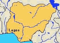
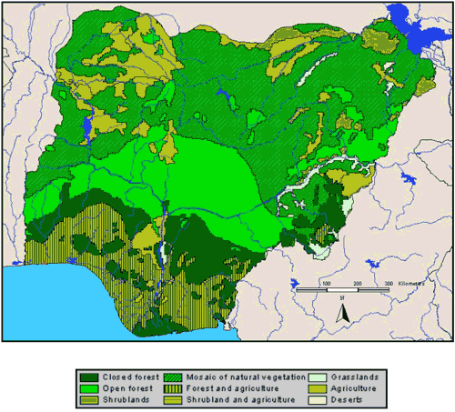
On the previous and this page are displayed the locator map and forest cover map for Nigeria, respectively. Note that these are not the actual sizes as they are used on the web page. Also, the typical resolution of a computer screen is less than typical printed resolution, giving a somewhat reduced quality in this report.
Updating the current maps can be achieved fairly easily using the AMLs developed for producing the first series of locator and forest cover maps. There are essentially three types of update:
1. Topological updates
2. Attribute updates
3. Design and content changes
Topological updates will not occur frequently. It implies that a national boundary is changed, for instance, but it also is required when new forest cover data is used for the forest cover maps. A capital city might be moved. Topological changes in hydrology are unlikely.
If a (artificial) national boundary changes, then both the locator and forest cover maps have to be updated. Apart from that, also neighbouring country maps will be invalidated, because these also display borders between countries. A neighbouring country in this context does not imply topological contiguity. Brazil, for instance, includes most countries of South America in its two maps, including parts of Ecuador and Chile. It is quite cumbersome to dynamically identify which countries include (parts of) the country for which the topology is updated, particularly since the locator maps are projected. This will therefore necessarily be an operation requiring operator action. It is, however, not always necessary to update maps of big countries if small countries change borders. The locator map of the Russian Federation, for instance, spans such a large area that details in smaller countries are completely lost due to the resolution of the locator map.
When forest cover data changes, this usually involves updating all the forest cover maps for countries falling in the affected sub-regions. This is a result of the design of the database. Since the forest cover is displayed only for the country in question, there are no implications for neighbouring countries that fall outside of the affected sub-regions.
When a capital city is moved (e.g. in the case of the Federal Republic of Germany from Bonn to Berlin) only the maps of the country in question need to be updated
Attribute changes will not occur frequently. A capital city name might be changed, or the classification scheme for forest cover types. If at a later stage more elements are added to the locator and forest cover maps the occurrence of attribute changes might well increase, particularly if annotation is added to the maps. Depending on design decisions such additions may provoke the invalidation of neighbouring maps. Currently no such dependencies exist.
If any design or content changes are made to the locator or forest cover maps (e.g. colour scheme, features, annotation, classification scheme for forest cover) such changes are likely to be pervasive, affecting all locator and forest cover maps. In this case the routines used to produce the maps should be updated to incorporate the desired changes and a whole new series of maps should be generated using the adjusted routines.
For the graphics produced by the routines to actually appear on the web site, the graphics need to be inserted in the appropriate database and referenced by the scripts that create the pages. These operations are outside of the scope of this assignment and should be discussed with the web programmer.
![]()
![]()
![]()