


The sample of satellite scenes was based on scenes located in the actual regions of Monte and Espinal. Due to a big heterogeneity in distribution of forest formations in the region of Espinal this region was divided into three subregions, Ñandubay, Algarrobal and Caldén, to perform a stratified sampling which better reflected the distribution of the forest formations. The region of Monte represented a larger area than the region of Espinal, but because of the bigger heterogeneity in the region of Espinal it was motivated to assign six satellite scenes to both regions, whereof two scenes was assigned to each one of the subregions of Espinal.
The sample of the satellite scenes was stratify-oriented and selected by random. However when the outcome of the random selection resulted in a distribution of scenes not reflecting the composition of vegetation in the regions/subregions, according to forestry officers at the Native Forest Division, the random function was reinitiated until an acceptable distribution was achieved.
Preparing the selected scenes for interpretation it turned out that one of the scenes, P231/R078, did not fall inside the extension of the actual region Monte and was therefore excluded from the sample. So finally the sample consisted of 11 scenes. The loss of one satellite scene in the sample for the region of Monte was to some extent compensated by satellite scenes in the region of Espinal overlapping into the region of Monte, see Figure 3.
As a consequence of the sample method the different satellite scenes represented areas of different size within the actual regions. Two methods were employed to estimate the total forest cover in each region/subregion. The first method, based on a partial aggregation, gives equal importance to each interpreted satellite scenes without considering the actual area studied contrary to the second method, based on global proportional estimation which considers the forest area in each scene, rather than the forest concentration. Because of varying studied area in the different scenes only the first method gave a statistically recognised outcome, since the second method gave higher importance to the scenes with a larger area studied. Due to its statistically poor characteristics, the results from the second method were not employed in the final estimation of the total forest cover.
The identification of native forests in dry zones as Monte and Espinal is rather difficult taking in consideration that the types of forest in these semiarid regions do not reach any appreciable heights and that the spectral characteristics are very similar to dense shrubs in satellite images. The main difficulty was to distinguish open forests from shrubs. The problem was partly a matter of the definitions between forest and shrubs, as described in FRA Working Paper 1 (FAO, 1998) and partly a question of the influence the ground vegetation had in the spectral reflection from open forests.
Since forest is defined by a composition of trees, and the definition of tree is wooded species that reach a height of at least 5 meters under ideal conditions, many of the forest formations did not differ much from the high growing shrubs, which made it technically complicated to determine whether it was a forest or just dense high growing shrubs.
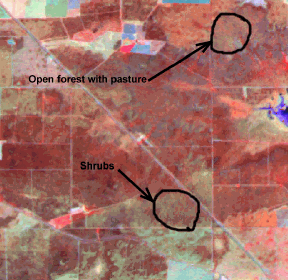
Figure 6 Similarity in spectral signal between shrubs and open forest with pastures.
In the open forests ground vegetation had a big effect on the total spectral reflection, especially if the ground vegetation was grass. The spectral signal from grasses depends much on the growing stage of the grass. When the grass is fresh and growing fast it has a high reflection in Near IR, indicating a large amount of growing biomass and thus contributing to the growing biomass in the forest, whilst withered grass does not absorb much radiation of any wavelength and therefore gives a very high total spectral reflection. The relation between the reflection in Near IR and the total spectral reflection from withered grass implicates a very small amount of growing biomass which can totally overcome the existence of open forests.
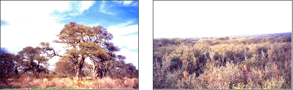
Figure 7. Open forest with a ground cover of Figure 8 Dense medium height shrubs dry grass giving a spectral reflectance similar to dense shrubs.
The date when the satellite scenes were shot influences significantly the interpretation of the vegetation. If a scene is shot during the dry season (low growing season in studied areas) the detection of woody vegetation will, in these semi-arid regions, be affected negatively and their extension be underestimated.
Most of the satellite scenes in the sample were shot during December - March (Appendix 5), which is the active growing season with maximum vegetation foliage in the studied area. However, due to difficulties in acquiring cloud free scenes, some of the scenes shot in May respectively September were employed. Variation in time for different scenes leads to a variation in forest area detected by the interpretation. This variation is however hard to quantify without reviewing time series of satellite scenes.
The geographical extensions of the phytogeographical regions/subregions of Monte and Espinal are relative and change dynamically over the years depending on changes in the macroclimate. The exact actual extension of the regions can therefore not be determined until the national forest inventory is completed. In the sample, the extensions for the Regions of Monte and Espinal are the ones actually employed by the Argentinean Native Forest Division in their definition of phytogeographical zones of Argentina. Changes in the regional extensions can therefore be required and thus affect the result of this study.
The field visit to verify the visual interpretation of the satellite scenes was carried out together with the Argentinean Native Forest Division as a joint effort mission. Due to restricted financial and time resources the field visit was limited to one week and concentrated to a zone with forest formations representative for major parts of the studied regions. The limited area visited for ground-truthing is not to be considered as a major bias in the calibration of the interpreted satellite scenes, since the training areas selected were representative for major parts of the regions and since the scenes outside the visited area did not comprise major forest formations.
During the field visit control points were selected according to their accessibility and representativity and they were captured with GPS to make a good representation of different types of vegetation cover, as training areas for calibration of the visual interpretation. Without claiming any quantitative estimation of the error in the calculation of forest cover, the control points were employed to give an indication of the precision in the area estimates. In total, 33 control points (Appendix 2) were located within the study area and used for this error indication. 13 of the control points were in the visual interpretation set as forest cover and 20 as non-forest cover (Table 5).
Table 5. Correlation between visual interpretation and ground control, showing number of control points in either forest area or none-forest area.
Ground Control |
Visual Interpretation |
TOTAL | |
Forest |
Not Forest | ||
Forest - without pasture |
9 |
3 |
|
- with pasture |
2 |
3 | |
11 |
6 |
17 | |
Not Forest - Burnt Area |
2 |
||
- Shrubs |
2 |
9 | |
- Grassland |
3 | ||
2 |
14 |
16 | |
TOTAL |
13 |
20 |
33 |
Of total 16 control points in non-forest areas 12 percent were interpreted as forests. Saying that of the forest cover interpretations 85 percent were proved to be forest areas in the ground control while remaining 15 percent were non-forest areas. These 15 percent (two control points) were in fact shrubs that had a similar spectral reflection to forest areas and represented large areas in the satellite scenes. These "forest-like" shrub areas were corrected in the second phase of the interpretation.
Of the non-forest cover interpretations 70 percent were proven to be area without forest cover while remaining 30 percent turned out to be forest areas. Saying that of total 17 control points in forest areas 65 percent were interpreted as forests of which 70 percent were forests without pasture and 30 percent forests with pasture. 75 percent of the forests without pasture were interpreted as forest areas while only 40 percent of the forests with pasture were interpreted as forest areas, indicating an underestimation of forest cover, especially in areas of open forests with pasture. Correction of these misinterpreted control points was only applied within the visited area, since it was difficult to distinguish with precision the different woody vegetation types from each other without field controls.
To get more accurate estimations of the precision in the results of the study more control points must be registered and be more systematically sampled.
This study presents an estimation of the native forest in the regions of Monte and Espinal: 36 000 ha and 530 000 ha respectively. Even though the figures presented by this study imply an underestimation of the forest cover, they are significantly lower than earlier estimations made by Argentinean authorities (1 900 000 ha and 3 200 000 ha, see Appendix 1). The big difference in the results achieved, indicates that a revision of earlier Argentinean forest cover statistics is needed and that further efforts should be made to update them.
FRA 2000 applies available data and will therefore have to rely on data compiled from provincial and regional inventories of different quality (Appendix 1) where the ongoing national forest inventories not will be able to in time provide the information required.
