


Presented by
A. A. Arara & O.
Dreza
Bironi
Remote Sensing Centre
1. INTRODUCTION
A Geographical Information System
(GIS) is a computer-based approach to the storage, manipulation, analysis, and output of
geographic information. The main objective of GIS work for LIBFISH is to allow easy storage and
treatment of data collected during the execution of Project activities, with an
initial concentration on selection of suitable sites for aquaculture
development.
Organising such a GIS requires a great deal of effort and participation of many other
institutions and departments. The data collection and accumulation phase is the most
difficult and time-consuming period in the establishment of any GIS, and
requires an efficient data collection system. To justify their high cost, GIS activities should
be extended to other applications such as development planning of the coastal
zone and environmental studies.
2. PROPOSAL FOR THE ORGANISATION
OF A GIS
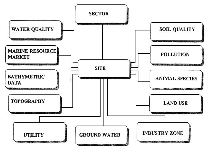
The working group has
proposed the general structure of the LIBFISH GIS for preliminary aquaculture site
selection purposes. Data pertaining to particular sites should be collected
from many sources
are then stored on tables. Relations should then be established between the tables
for further analysis and processing (Figure IX/1).
A few forms have
already been filled out using data from known sites (see examples, Attachment XI/1). The purpose of
this pilot work is to test the forms and to modify them as necessary. At the
same time
the forms are being distributed to various Project and MBRC experts for review
and comment. When the forms are finalised, a data collection group should be formed to
carry on with the work. After the data are entered into the computer, analysis can
proceed on the basis of site selection requirements.
3. CONCLUSION
In brief, data
collection and organisation is an essential task for a GIS setup. A database
should be organised
as soon as possible in order to facilitate aquaculture site selection work.
Whilst a GIS may not be an absolute requirement for such work, it is a
suitable first application point and should prove easy to build upon, so that
it becomes part of a wider GIS programme integrating a variety of activities
and purposes.
Figure XI/1
Attachment XI/1.
Example Data Collection Forms:
Libyan Aquaculture Site Database
(Nov–Dec. 1994)
| Site-no | Site-name | Site-type | Location | Remarks |
| Long. | Lat. |
| | | | | | |
| Temperature | Salinity | Oxygen | Colour | Turbidity | Water source | Water circulation | Remarks |
| Max. | Min. |
| -----°C | -----°C | --------g/l | --.--mg/l | | --,--m | | Exist (.....) | |
| Docs not Exist (.....) |
| Depth | Currents | Surface-type | Waves | Remarks |
| Max. | Min. | Direction | Speed |
| -----m | -----m | -------Deg | -----m/sec | Soft ( ) | | |
| Hard( ) |
| Height | Wind | Soil-type code | Land-use code | Drainage Facility | Remarks |
| Max. | Min. |
| -----m | -----m | -----Deg | | | | |
| Type1 - Industrial | Type2 - Urban | Type3 - Agriculture | Type4 - Petroleum | Remarks |
| Liquid ( ) ............ | Sewage ( ) ............ | Pesticides ( ) ............ | Factories ( ) ............ | |
| Solid ( ) ............ | Garbage( ) ............ | Fertilizers ( ) ............ | Ships ( ) ............ | |
| | | Solid Waste ( ) ...... | | |
| Soil-type | Consistency | Particle size analysis | Remarks |
| Rock | | | |
| Soft: | Water proof ( ) |
| Permeability ( ) |
| Land-unit area | Cover | Owner code | Potential Dev. | Remarks |
| | | | | |
| Road-No. | Road-type | Length | Width | Const. Date | Distance from site | Remarks |
| | | | | | ........meters | |
| Line-No. | Voltage | Distance from site | Remarks |
| | | ......................Km | |
| Pipe - No. | Radius | Water Quality | Water source type | Distance from site | Remarks |
| | | | | | |
| Location | Volume per day | Distance from site | Remarks |
| Long. | Lat. |
| | | | | |
| Market-No. | Distance from site | Market Name | Location | Statistics | Range of request | Remarks |
| Long. | Lat. |
| | ............km | | | | | | |
| | ............km | | | | | | |
| | ............km | | | | | | |
