


The following example illustrates country reporting for table T1, following the structure proposed in the Template for Country Reporting. The example shows how the standard methodology can be applied when completing a reporting table. The national data in this example are entirely hypothetical and does not correspond to any specific country.
Category |
Definition |
Forest |
Land spanning more than 0.5 hectares with trees higher than 5 meters and a canopy cover of more than 10 percent, or trees able to reach these thresholds in situ. It does not include land that is predominantly under agricultural or urban land use. |
Other wooded Land |
Land not classified as Forest, spanning more than 0.5 hectares; with trees higher than 5 meters and a canopy cover of 5-10 percent, or trees able to reach these thresholds in situ; or with a combined cover of shrubs, bushes and trees above 10 percent. It does not include land that is predominantly under agricultural or urban land use. |
Other land |
All land that is not classified as Forest or Other Wooded Land. |
Other land with tree cover (Subordinated to Other land) |
Land classified as Other land, spanning more than 0.5 hectares with a canopy cover of more than 10 percent of trees able to reach a height of 5 meters at maturity. |
Inland water bodies |
Inland water bodies generally include major rivers, lakes and water reservoirs. |
2.2.1. National data sources
References to sources of information |
Quality (H/M/L) |
Variable |
Years |
Additional comments |
a) Smith, B 1988. National Pine forest and mangrove inventory. Hypothetical country |
M1 |
Land use, Forest cover, Growing stock |
1986 |
National inventory of pine and mangrove forests covering the whole country, using remote sensing and field sample plots. |
b) Grove 2000., N. Forestry national report on state of the forest to the year 2000 for Hypothetical country. |
M1 |
Forest cover |
1992 |
Analysis of forest cover based on satellite images. |
c) Forestry Department 2003. State of the forest. Hypothetical country |
L2 |
Forest cover change |
2000 |
Provides secondary information on trends of forest cover in the country according to expert knowledge. |
1 Assessed as Medium quality M. The source document only provides information for two of the three main forest classes.
2 Assessed as Low quality L. Reference is based on expert knowledge not supported by field information.
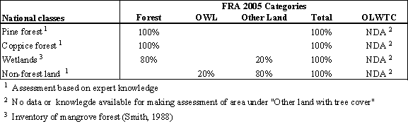
2.2.2. National classifications and definitions
National class |
Definition |
Coppice forest |
The coppice hardwood forests are native forests of various hardwood species such as buttonwood, mahogany, gum elemi, rat wood, black ebony, braziletto, horseflesh and red cedar. |
Pine forest |
Pine forests of Pinus caribaea. |
Wetlands |
Land that includes the mangrove forest ecosystems which occurs predominantly on the shores of the country covering the 80 percent of the total wetland. It also includes swamps, and low lands. |
Forest land |
Includes all land classified as Coppice forest, Pine forest and Wetlands. |
Non-forest land |
Includes all land not classified as forest land. |
Information on threshold values (canopy cover, tree height, etc.) used for defining Forest and Other wooded land in FRA 2005 is not defined in national definitions. For that reason, based on local expert advice, it is assumed that national definitions of "pine forests", "coppice forest" and "mangrove forest" correspond with the FRA 2005 thresholds for classifying them as "Forest".
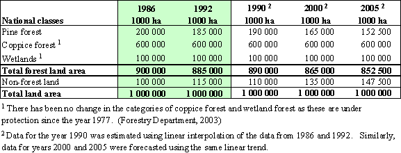
2.2.3. Original national data
1986 1000 ha |
1992 1000 ha | |
Pine forest |
200,000 |
185,000 |
Coppice forest1 |
600,000 |
600,000 |
Wetland |
100,000 |
100,000 |
Total forest land |
900,000 |
885,000 |
Non-forest land 2 |
100,000 |
115,000 |
Total land area |
1,000,000 |
1,000,000 |
1) Estimated from original data as: Total forest land area - area of pine forest area of wetland
2) Estimated from original data as: Total land area Total forest land area
Note that national data does not provide any assessment of the area of Coppice forest.
Additionally, the inventory of the mangrove forests (Smith, 1988) showed that of the wetlands, 80% of the area was covered by mangrove forests and the remaining 20% were swamps.
2.3.1. Calibration
Source |
Total land area (1000 hectares) |
National data |
1,000,000 |
FAOSTAT |
1,000,000 |
There is no need to perform calibration since the national land area data matches the FAOSTAT land area.
2.3.2. Estimation and forecasting
The estimated and forecasted figures are considered by local expertise to well describe the current state and trends.
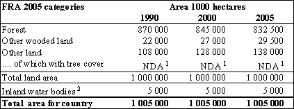
1 No data available
2 Data on area of inland water bodies from FAOSTAT
The main weakness in the existing national data is the lack of information on the Coppice forest. Another weakness is that there is no national information available on Other land, and particularly the part of Other land that has a tree cover.
