Following the example of what was done for the tropical countries, a statistical model was set up enabling one to express - and therefore also to predict - changes in forest cover as a function of known explanatory variables such as population, livestock, fires, etc. A differentiated study was performed on each sub-region (North Africa, Near East) in order to take into account each one's different characteristics and dynamics. The study was based on sub-national level data - whenever they were available - from which the sub-regional models were derived.
The following diagram shows relative forest cover as a function of rural population density:
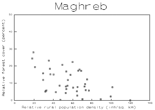
Forest density has been used as a dependent variable in a multi-linear regression analysis, using a step by step selection procedure to test the combined effect of multiple variables and the model's sensitivity.
The following table shows the results of this step-by-step selection:
Step 1: Partial correlation of individual variables
| Variables | Partial correlation | |
| R | R2 | |
| Moist mountain zone | 0.765 | 0.585 |
| Rural population density | 0.752 | 0.566 |
| Livestock density | 0.542 | 0.294 |
| Total population density | 0.500 | 0.250 |
| Weck Climate Index | 0.421 | 0.177 |
Step 2: Selecting the variables
The “mountain moist zone” variable is the most significant with an R2 value of 0.585.
The second variable added to the analysis is rural population density. The two variables combined raise R2 to 0.686.
After including rural population in the model, the other variables are no longer significant since their partial correlation is poor.
Step 3: Resulting adjustments to the model
The model selected is as follows:
Y = a + bx + cz
Where Y = relative forest cover
x = percentage of forest area in the “mountain moist zone” class
z = rural population density
and the values calculated for the parameters are:
a = 16.913
b = 0.164
c = -0.138
Adjustment to the model: R2 (adjusted): 0.6862; degrees of freedom = 20
| Independent variable | Coefficient | Standard deviation | Significance level |
| a = 16.912796 | 3.272101 | 0.0000 | |
| x = mountain moist zone | b = 0.164327 | 0.050782 | 0.0041 |
| z = rural population density | c = -0.137958 | 0.045777 | 0.0069 |
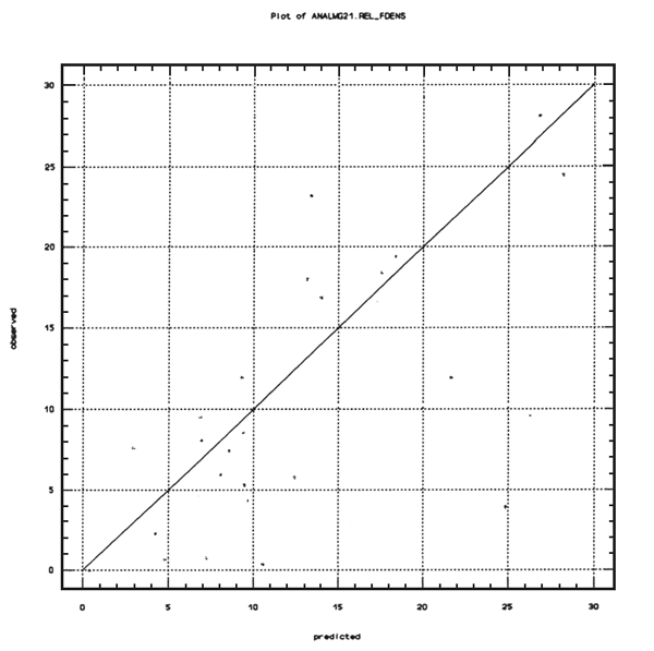
The model selected represents the rate of forest cover for a given location expressed in terms of a function.
The graph of observed values (Y) against predicted values (X) is shown below:
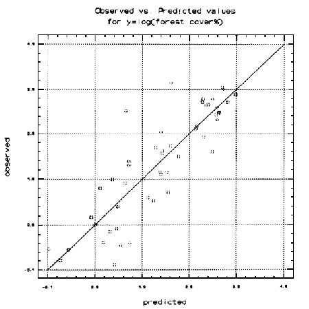
A step by step regression analysis was done using data on forest cover, population density and bioclimatic zones. The best adjustment was obtained using the forest cover logarithm as a function of population density and bioclimatic zones, expressed as follows:
Log (forest cover) = a*x1 + b*x2 … k*xn
The model selected was not constant, and the remaining values were weighted for forest cover in each region. It has a strong R2 (0.98) and the selected variables cover all the bioclimatic zones except the desertic and glacial zones. Each bioclimatic zone has an associated parameter which is stronger if the zone is more forested. The strongest parameters are found in class 3 (temperate with brief dry periods, classes 2b and 2c (dry and humid Mediterranean), and class 7 (cold temperate).
The variance is further explained by the bioclimatic conditions, but population density is still a statistically significant influence, characterised by a negative coefficient. The loss of forest cover as a result of human pressure and bioclimatic conditions was used to standardise the forest cover in 1990 and to estimate the changes in natural forest area.
The graph below plots observed values against predicted values:
Country data, split at sub-national level by bioclimatic zone, made it possible to show that:
forest cover is all the greater as the bioclimatic zone is more humid,
forest cover is inversely proportional to population.
ALGERIE
COUVERTURE FORESTIERE ET POPULATION
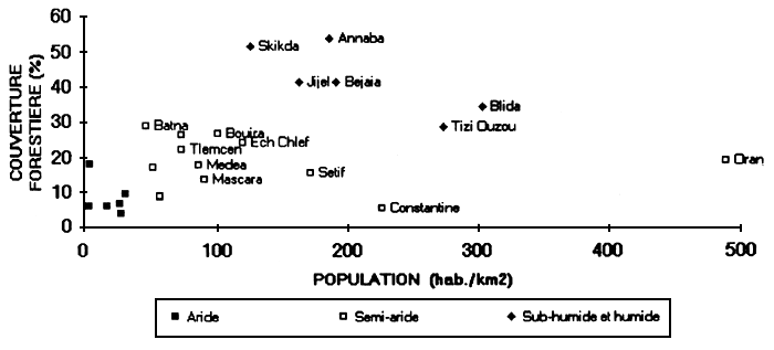
Algiers, whose population density is greater than 3,000 inhabitants/km2, is not shown in this graph.
Arid zone
No link appears between the variables “forest cover” (FOR COV) and “human population” (POP TOT) in the arid zone. However, if the livestock variable (LIV) is excluded, the relationship is negative with a fairly weak regression R.
The linear equation describing this relationship is:
| FOR COV = 22,371 - 17,896 * POP TOT - 0,134 * LIV | R2 = 0,56 |
Semi-arid zone
Whether or not one includes Oran, which is considerably displaced in the graphs shown, no significant link appears in the semi-arid zone, whether with the “forest cover”, “human population” or “livestock” variables.
Sub-humid and moist zone
Whether or not one includes Algiers, which is considerably displaced in the graphs shown, in the analysis a strong link appears between forest cover, population and livestock.
If one includes Algiers, the linear equation which describes this relation is:
| FOR COV = 44,298 - 0,011 * POP TOT | R2 = 0,67 |
Taking the LIV variable into account does not improve the relationship since R2 remains the same at 0,67.
If Algiers is excluded, the linear equation describing the relationship is:
| FOR COV = 44,298 - 0,011 * POP TOT | R2 = 0,63 |
MAROC
COUVERTURE FORESTIERE ET POPULATION
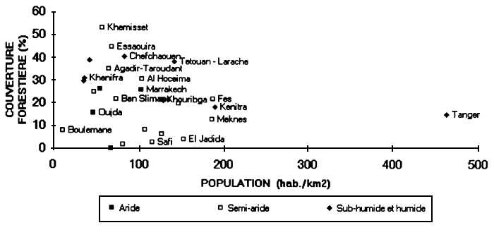
Casablanca and Rabat, the population densities of which are 2,000 and 1,200 inhabitants/km2, respectively, are not represented in this graph.
No link appears between the variables FOR COV, POP TOT or LIV, whether in arid or semi-arid zone, nor even in the sub-humid zone with Rabat included.
On the other hand, if one excludes Rabat from the sub-humid zone analysis, a relationship appears between FOR COV and POP TOT. The linear equation describing this relationship is:
| FOR COV = 36,052 - 0,049 * POP TOT | R2 = 0,48 |
Taking POP RUR into account does not improve the relationship since R2 remains at 0.48; but taking the LIV variable into account significantly improves the relationship, the linear description of which becomes:
| FOR COV = 36,365 - 0,028 * POP TOT + 0,102 * POP RUR - 0,047 * LIV | R2 = 0,57 |
TUNISIE
COUVERTURE FORESTIERE ET POPULATION
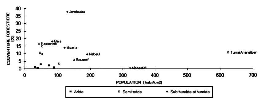
Arid zone
No relationship appears between the variables “forest cover” and “human population” in the arid zone. On the other hand the relationship between “forest cover” and “livestock” is positive with a fairly poor R2 value of (0.53), which may be explained by a certain concentration of livestock in the zones where there is forest cover.
Semi-arid zone
If one includes Tunis, which is considerably displaced in the graph, there is no significant link in the semi-arid zone, whether between the variables FOR COV, POP TOT or LIV.
However, if Tunis is excluded from the analysis, a strong link appears between “forest cover” and “population”. The linear equation describing this relationship is:
| FOR COV = 13,967 - 0,047 * POP TOT | R2 = 0,65 |
Taking the two other variables into account - POP RUR and LIV does not improve the relationship since R2 remains at 0.65.
Sub-humid and moist zone
No significant link appears in the sub-humid zone between any of the FOR COV, POP TOT, or LIV variables.
1. Method
Collecting data from the FAO yearbooks on forest products enables apparent wood consumption to be calculated and compared among the different countries.
| Country | Round wood yield | Consumption | Balance of trade | Satisfaction | Yield | Est./declared yield | ||
|---|---|---|---|---|---|---|---|---|
| Fuelwood | Ind. round wood | Total | ||||||
| m3/hab | m3/hab | m3hab | m3rwe/hab | m3 rwe/hab | Prod./Cons | m3/ha | m3 | |
| Algeria | 0.09 | 0.08 | 0.08 | 0.15 | 0.07 | 1.08 | 0.59 | 2 162 |
| Egypt | 0.04 | 0.04 | 0.07 | 0.11 | 0.06 | 0.97 | 72.52 | 2 248 |
| Libya | 0.14 | 0.12 | 0.08 | 0.19 | 0.06 | 1.08 | 1.40 | 643 |
| Morocco | 0.09 | 0.40 | 0.06 | 0.45 | 0.02 | 0.20 | 0.44 | 2 136 |
| Tunisia | 0.39 | 0.77 | 0.11 | 0.88 | 0.09 | 0.50 | 3.44 | 3 213 |
| Afghanistan | 0.39 | 0.30 | 0.06 | 0.35 | 0.01 | 1.13 | 4.31 | 6 465 |
| Bahrain | 0.12 | 0.05 | 0.02 | 0.07 | 0.01 | 2.04 | 0.54 | 6 727 |
| Iran, Islamic Rep. of | 0.00 | 0.00 | 0.05 | 0.05 | 0.05 | … | 0.06 | 9 |
| Iraq | … | 0.03 | 0.15 | 0.18 | 0.18 | … | 0.00 | … |
| Jordan | 0.17 | 0.17 | 0.12 | 0.29 | 0.08 | 0.83 | 6.40 | 457 |
| Kuwait | … | 0.00 | 0.12 | 0.12 | 0.12 | … | … | … |
| Lebanon | … | 0.10 | 0.08 | 0.18 | 0.18 | … | … | … |
| Oman | 0.00 | 0.01 | 0.14 | 0.15 | 0.15 | … | 0.00 | … |
| Qatar | 0.01 | 0.00 | 0.06 | 0.06 | 0.05 | 0.76 | 0.18 | 86 |
| Saudi Arabia | … | 0.01 | 0.28 | 0.29 | 0.29 | … | … | … |
| Syria | … | 0.00 | 0.00 | 0.00 | 0.00 | … | 0.00 | … |
| United Arab Emirates | 0.01 | 0.01 | 0.03 | 0.03 | 0.03 | 1.23 | 0.08 | 155 |
| Yemen | 0.03 | 0.03 | 0.01 | 0.03 | 0.01 | 1.00 | 0.08 | 324 |
| Minimum | 0.00 | 0.00 | 0.00 | 0.00 | 0.00 | 0.00 | 0.00 | |
| Average | 0.08 | 0.12 | 0.08 | 0.20 | 0.08 | 0.60 | 5.00 | |
| Maximum | 0.39 | 0.77 | 0.28 | 0.88 | 0.29 | 2.04 | 72.52 | |
2. Apparent consumption of national forest products
For certain countries this compilation results in a satisfaction index of less than 1, in other words a negative difference between the national yield and the consumption of forest products originating from the national resource.
This difference can only be explained by an over-exploitation of national forest resources or an under-declaration of forest product imports. The two elements are superimposed and it is probable that the former is the more significant.
This observation enabled an initial “modification” to be made to the data, by recalculating the yield on the basis of satisfaction of the entire consumption. This modification brings certain countries' yields to levels which are more realistic than those they declared.
3. Fuel-wood consumption
For most countries wood consumption per inhabitant calculated by this method is too low (from 0.01 to 0.30 m3/yr/inhabitant) which is considerably lower than the average of 0.5 to 1 m3/yr/inhabitant generally found in many countries whatever their level of development. To take an example, it is difficult to believe that Jordan only consumes 0.05 m3/yr/inhabitant when Morocco and Tunisia consume 0.45 and 0.77 m3/yr/inhabitant respectively.
This observation suggested that the data could be “modified” a second time by:
recalculating a more realistic fuel-wood consumption figure for each country on the basis of the highest fuel-wood consumption observed in the zone: 0.77 m3/yr/inhabitant (Tunisia);
recalculate the yield for each country on the basis of satisfying all this rectified consumption.
Although it records the highest fuel-wood consumption per inhabitant, Tunisia was chosen for two reasons:
this country is quite highly developed, which generally reduces fuel-wood consumption when compared to less developed countries;
it is very unlikely that the consumption of fuel-wood to satisfy energy needs is over-estimated.
This second modification brings certain countries' yield up much higher than the figure recorded in the statistics.
4. Industrial wood consumption
Two countries, Iran and Iraq, have a satisfaction index greater than 1.2, in other words a yield in excess by over 20 per cent but without exports of round wood explaining this difference. The excess can only be explained by:
exports, which seems improbable, or
the production of wood-based products being under-declared.
This second explanation is more plausible; it is supported by the low level of industrial wood consumption observed in Iran and Iraq (0.02 and 0.03 m3/yr/inhabitant respectively, while in most countries industrial wood consumption per inhabitant is close to the average of 0.09m3/yr/inhabitant). It is difficult to believe that Iran, given its level of development only consumes 0.02m3/yr/inhabitant of industrial wood, while most countries in the zone being studied consume from 0.06 to 0.15m3/yr/inhabitant.
This observation gave rise to a third “modification” of the data:
recalculating a more realistic industrial wood consumption based on such consumption in Tunisia: 0.11m3/yr/inhabitant (a slightly higher figure than the average);
recalculating the yield on the basis of satisfying all this modified consumption.
The results of these three modifications are shown in the table overleaf.
| Country | Declared yield | Modification 1 | Modification 2 | Modification 3 | ||||||
|---|---|---|---|---|---|---|---|---|---|---|
| Adjusted yield | Adjusted ratio | Adjusted yield | Adjusted yield | Adjusted ratio | Adjusted yield | Adjusted yield | Adjusted ratio | Adjusted yield | ||
| m3 | m3 | m3/ha | m3 | m3/ha | m3 | m3/ha | ||||
| Algeria | 2 162 | 2 162 | 1.00 | 0.59 | 19 484 | 9.01 | 5.31 | 20 261 | 9.37 | 5.52 |
| Libya | 643 | 643 | 1.00 | 1.40 | 3 607 | 5.61 | 7.84 | 3 732 | 5.80 | 8.11 |
| Morocco | 643 | 10 754 | 5.03 | 2.20 | 20 155 | 9.44 | 4.12 | 21 599 | 10.11 | 4.41 |
| Tunisia | 2 136 | 6 487 | 2.02 | 6.95 | 6 487 | 2.02 | 6.95 | 6 487 | 2.02 | 6.95 |
| Afghanistan | 6 465 | 6 465 | 1.00 | 4.31 | 14 291 | 2.21 | 9.53 | 14 495 | 2.24 | 9.66 |
| Iran, Islamic Rep. of | 155 | 155 | 1.00 | 0.08 | 14 621 | 94.33 | 7.74 | 16 230 | 104.71 | 8.59 |
| Iraq | 9 | 5 | 0.56 | 0.03 | 2 523 | 280.30 | 16.75 | 2 728 | 303.07 | 18.11 |
| Jordan | 467 | 562 | 1.20 | 7.69 | 2 175 | 4.66 | 29.79 | 2 158 | 4.62 | 29.56 |
| Lebanon | … | … | … | … | 10 784 | … | 8.99 | 10 362 | … | 8.64 |
| Saudi Arabia | 6 727 | 6 727 | 1.00 | 0.54 | 46 319 | 6.89 | 3.74 | 47 754 | 7.10 | 3.85 |
| Syria | 86 | 113 | 1.31 | 0.24 | 9 715 | 112.97 | 20.63 | 10 447 | 121.47 | 22.18 |
| Yemen | 324 | 324 | 1.00 | 0.08 | 9 002 | 27.78 | 2.22 | 10 267 | 31.69 | 2.53 |
5. Conclusion
However well founded the assimilation hypotheses with regard to consumption in the different countries, it is difficult not to give some credit to these ratios calculated from data supplied by the countries themselves.
Without regarding them as anything but estimates, the accuracy of which cannot be gauged, the results from this adjustment lead us to suggest that there is probably a fairly large under-estimation of the real consumption of forest products taken from the forests of the countries in the Mediterranean zone. The yield figures from 4 to 30 m3/yr/inhabitant in already very degraded forest formations has to be taken very seriously, even though they are extremely approximate.
NORTH AFRICA
The 1980 estimates have been retained unchanged for Egypt and Libya
● Algeria
Natural forest area is 1,544,000 ha, and that of other forested lands 1,906,000 ha, in other words a total forested area of 4,153,000 ha according to the 1984 National Forest Inventory.
The estimated plantations area at the end of 1985 was 693,000 ha. In the absence of reliable quantitative information on the areas planted and their success rate, it would not be prudent to suggest a different figure. Nevertheless, according to official sources, the total figure for reforestation actually taking place between 1981 and 1990 would be 379,000 ha.
● Egypt
There is no natural forest, the wooded area therefore consists of alignment plantations on irrigated land, the purpose of which is to protect and to be an accessory to production. The estimate of 48,000 ha of plantations from 1985 has been retained.
● Libya
The 1980 estimates giving 190,000 ha of natural forest and 446,000 ha of other forested lands have been retained.
● Morocco
Natural forest area covers 3,543,000 ha and that of other wooded lands 1,880,000 ha.
The area dedicated to plantations has increased as follows:
| - end of 1979/80 campaign | 321,000 ha |
| - end of 1983/84 campaign | 401,204 ha |
- successful reforestation 1984/85 (61 per cent of the planted area) | +90,177 ha |
| - losses in campaigns 1984–89 | -33,691 ha |
| - end of campaigns 1989–90 | 457,690 ha |
● Tunisia
Natural forest area is 368,000 ha; other wooded lands have not been reflected in the official statistics.
The 1980 estimate of plantation areas was 127,000 ha. According to the General Management for Forests at the Ministry of Agriculture, reforestation carried out in State forests (including for arresting dunes) and in the private and collective sector are 260,000 ha and 27,000 ha respectively, giving a total of 287,000 ha at the end of 1990.
NEAR EAST
1980 estimates have been retained unaltered for Afghanistan, Bahrain, Lebanon, Iraq, Oman and Qatar.
● Afghanistan
Natural forest covers 1,191,000 ha, other forested lands 1,415,000 ha and plantations 11,000 ha.
● Bahrain
There is no forested area in Bahrain.
● Iran, Islamic Republic of
Natural forest area is 1,658,000 ha, mostly made up of forests in the region bordering the Caspian Sea. Other wooded areas cover 9,700,000 ha, or 6 per cent of the total area of the lands.
The area of plantations in place at the end of 1989 was assessed at 113,000 ha from official sources.
● Iraq
Natural forest area is 69,000 ha and other wooded lands cover 109,000 ha.
● Jordan
The natural forest, essentially comprising 25,000 ha of evergreen oak forests, and 3,000 ha of mixed pine forests, covers a total area of 28,000 ha. Other forested lands cover 122,000 ha and plantations 33,000 ha, giving a total of 183,000 ha.
● Kuwait
There is no natural forest in Kuwait. From 1966 to 1980, the Department of Agriculture performed 11 afforestation projects covering a total area of 7,200 ha.
● Lebanon
According to the reply to the FAO questionnaire, the total forested area is 120,000 ha, split 80,000 ha in natural forest and 40,000 ha in other wooded lands.
According to the soil use map produced by FAO in 1990, from interpreting satellite images, the natural forest area is 65,000 ha and other wooded lands 66,000 ha, giving a total of 149,000 ha.
In the absence of reliable information on the plantations set up, the 1980 estimates have been retained, giving 18,000 ha of plantations.
● Oman, Qatar
There are no natural or artificial forests in the states of Oman and Qatar.
● Saudi Arabia
Natural forest covers 201,000 ha, and other lands 700,000 ha, while plantations cover 1,000 ha.
● Syria
The total forested area of 539,000 ha has been divided - on the basis of bioclimatic zones, and in the absence of precise classifications and definitions - into 300,000 ha of forests (natural forest + plantations) and 239,000 ha of other lands. The plantations produced at the end of the 1989/90 campaign totalled 182,000 ha, while it is estimated that natural forest covers 118,000 ha.
● United Arab Emirates
There is no natural forest in U.A.E, but 85,000 ha of plantations were set up in 1989, according to official sources.
● Yemen
According to 1980 estimates, the total forested area was 4,060,000 ha, divided into 10,000 ha of broad leaved open forest (ex-North Yemen), and 4,050,000 ha of other wooded lands.
According to the response to the FAO questionnaire, total forested area was 2,145,000 ha, divided into 190,000 ha of natural forest and 1,955,000 ha of other wooded lands (excluding the agroforestry classes and date palms). Plantations for use as windbreaks and to arrest sand dunes were set up, but information concerning them is in the process of being collected and is not yet available.
According to the modelling exercise, the natural forest area is 9,000 ha, and that of other wooded lands 1,912,000 ha. In the absence of reliable information, plantations were not considered.