![]()
![]()
![]()
A record of all fishing stations is given in Annex II. The long lines fished were prepared by the Trinidad Fisheries Institute; the design of the bottom trawl is shown in Annex I.
The bottom long lines were intended to be tested for snapper and shark, especially on the outer shelf. The scarce echo recordings provided little direction for fishing locations. Between 200 and 400 hooks were set overnight on the Southern Delaware Bank, on the outer Manzanilla Bank and on two locations inside the shelf edge at 80 m depth at abt 10° 15’ N. About 200 kgs of tiger sharks were caught at the Delaware Bank, otherwise catches were negligable. Small catches of snapper and sharks were taken in a few of the bottom trawl stations (see below),but the general impression is that the availability of snappers in the area was low.
A significant part of the survey effort was spent surveying the slope outside 100 - 200 m for trawlable bottom and some hauls were made testing for deep sea shrimp. Smooth bottom was found in an area around 11° 10’N east of Tobago, but rather steep outside 300m. From 10° 20’N southwards to 10° 00’N and probably continuing, a gently sloping bottom was found from abt 200 m down to abt 500m. In this area the distance between the 100 m and 500 m bottom lines is 30 - 40 nm. Table 1 shows catch rates standardized to kg/hour for the 5 hauls made in the deep slope. Well over half the shrimp from st. 115 at 380 m depth was large sized high quality shrimp identified as a Solenocera species. On st. 119 at 400 m depth the gear stuck in clay heaps which however were discernable on the echo diagrams. The tests are too few for any conclusions as regards possible deep slope resources, but further explorations should be made especially of the relatively large southern area.
Table 1. Catch rates In deep slope trawl hauls standardized to kg/hour.
|
STA.NO. |
Shrimps |
Sharks |
Squid |
Other |
|
107 |
18.6 |
28.5 |
|
133.6 |
|
114 |
2.4 |
|
3.2 |
115.1 |
|
115 |
49.4 |
6.6 |
0.5 |
28.3 |
|
119 |
1.9 |
|
3.0 |
0.3 |
|
120 |
7.2 |
1.7 |
7.4 |
82.6 |
|
MEAN |
15.9 |
7.3 |
2.8 |
71.9 |
|
STA.NO. |
Deaersal |
Pelagic |
Sharks |
Squid |
Other |
|
103 |
165.1 |
162.8 |
|
8.4 |
70.6 |
|
104 |
2.4 |
328.8 |
|
0.4 |
22.8 |
|
105 |
|
114.7 |
|
3.2 |
|
|
106 |
27.0 |
0.2 |
|
1.4 |
12.0 |
|
109 |
3.3 |
189.0 |
|
3.9 |
29.5 |
|
110 |
15.1 |
6.5 |
|
6.4 |
3.2 |
|
112 |
37.8 |
66.8 |
13.2 |
2.4 |
62.7 |
|
113 |
69.1 |
17.2 |
1.8 |
9.6 |
14.7 |
|
118 |
66.0 |
385.2 |
|
|
73.6 |
|
121 |
6.4 |
137.8 |
|
|
14.4 |
|
MEAN |
39.2 |
140.9 |
1.5 |
3.5 |
30.3 |
Pooled samples of the size distributions of the most important species are shown in Annex III.
Table 3. Catch rates by families for demersal and pelagic fish in shelf trawl hauls, kg/hour.
DEMERSAL
|
STA. NO. |
Croakers |
Snappers |
Grunts |
Groupers |
Hairtails |
Other |
|
103 |
160.6 |
4.5 |
|
|
13.8 |
228.0 |
|
104 |
2.4 |
|
|
|
2.4 |
349.6 |
|
105 |
|
|
|
|
|
118.0 |
|
106 |
|
27.0 |
|
0.6 |
|
13.0 |
|
109 |
|
3.3 |
|
1.5 |
|
220.9 |
|
110 |
|
14.4 |
0.7 |
|
0.1 |
16.0 |
|
112 |
2.2 |
30.8 |
4.8 |
|
52.8 |
92.3 |
|
113 |
1.0 |
68.1 |
|
|
2.6 |
40.7 |
|
118 |
46.8 |
10.0 |
9.2 |
|
32.4 |
426.4 |
|
121 |
6.4 |
|
|
|
14.4 |
137.8 |
|
MEAN |
21.9 |
15.8 |
1.4 |
0.2 |
11.8 |
164.2 |
|
STA.NO. |
Anchovies |
Sardines |
Carangids |
Scombers |
Barracudas |
Other |
|
103 |
12.0 |
103.8 |
44.8 |
2.2 |
|
244.1 |
|
104 |
211.2 |
12.8 |
75.2 |
|
29.6 |
25.6 |
|
105 |
80.0 |
8.1 |
7.4 |
10.7 |
8.4 |
3.2 |
|
106 |
|
0.2 |
|
|
|
40.4 |
|
109 |
|
|
151.5 |
37.5 |
|
36.7 |
|
110 |
|
|
6.5 |
|
|
24.7 |
|
112 |
|
|
20.4 |
14.8 |
31.6. |
116.1 |
|
113 |
|
|
16.6 |
|
0.6 |
95.2 |
|
118 |
292.2 |
62.4 |
12.6 |
|
18.0 |
139.6 |
|
121 |
104.0 |
30.4 |
0.4 |
0.4 |
2.6 |
20.8 |
|
MEAN |
69.9 |
21.7 |
33.5 |
6.5 |
9.0 |
74.6 |
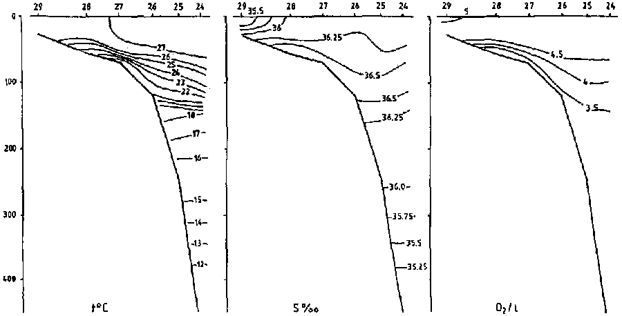
Figure 2. Temperature, salinity and oxygen in the hydrographic profile - NORTH OF TOBAGO 12.2 1988
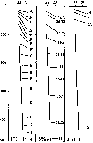
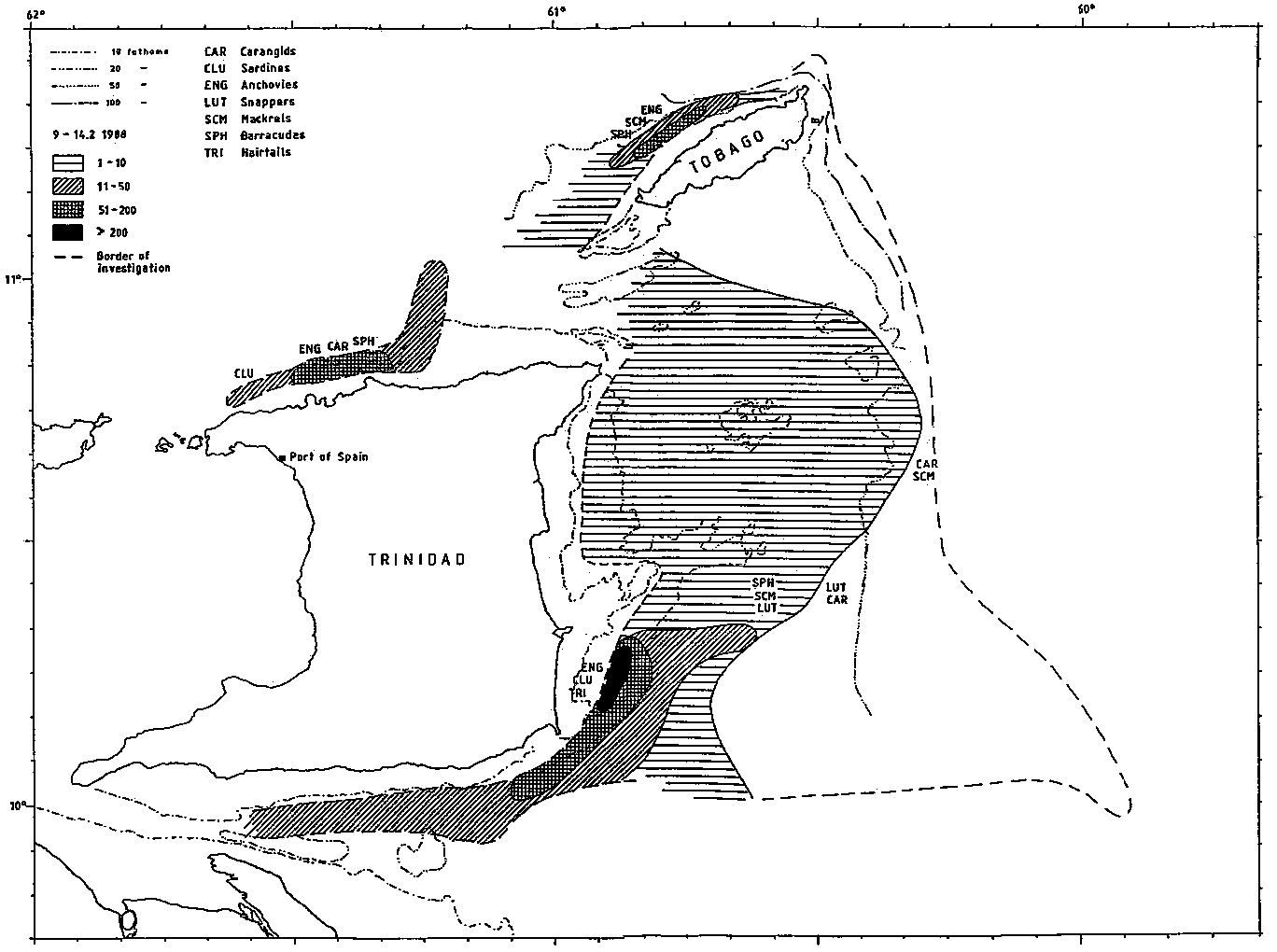
Figure 3. Fish distribution from the acoustic system.
![]()
![]()
![]()