![]()
![]()
![]()
Mr. Eang Savet,
Deputy Chief of Forest Management Office
Phnom Penh
FORESTRY IN CAMBODIA
Cambodia lies between latitudes 10o and 15o North and longitudes 102o and 108o East, covering an area of 181,535 square kilometers in the lower part of the Mekong Basin. The country shares borders with Thailand, Laos and Viet Nam. The total population of Cambodia was 11.43 million people in 1998, with a population growth rate of 2.4 percent per annum. Forests play a significant role in securing the livelihood of rural people. Although Cambodia has few mountainous areas, forests are essential for regulating the flow of water during the monsoon and dry seasons. In addition, forests are the economically most important renewable natural resource in terms of income generation for the private sector and the Government.
According to a 1997 survey based on satellite imagery, Cambodia was covered by 10.6 million hectares of forests (58 percent of the total land area). In comparison to 1970 inventory figures the country lost 2.6 million hectares or 14.4 percent of the forest cover within 30 years.
Major forest types are evergreen, semi-evergreen and deciduous dry dipterocarp forests. A special formation is the inundated freshwater forest surrounding Lake Tonle Sap. Not all forests are highly productive and the mean annual increment is estimated at around 0.5 cubic meters only. But as pointed out above, one of the main functions of forests lies in balancing the hydrological cycle under a monsoon climate and in providing a variety of social, cultural and environmental benefits for the 80 percent of people living in rural areas.
Protected areas comprise 3.3 million hectares of forests, about 18 percent of the total land area. This leaves an area of about 7.3 million hectares for production forestry. Concessions cover about 4.3 million hectares or 59 percent of the production forests. However, not all of them are presently operating. In principle, the preparation of master plans for concessions is the responsibility of the logging companies. These plans have to be approved by the Department of Forestry and Wildlife prior to commencement of harvesting operations. The Department of Forestry and Wildlife is also responsible for control of all forestry operations conducted by the concessionaires.
In view of the continued decline of the forest area, a reforestation program has been established since 1985. Up to 1999 the total areas planted amounted to 7,494 hectares, mostly with fast growing species, normally in the framework of tree planting on the occasion of National Arbor Day and Community events. Evidently, in view of annual forest losses through encroachment alone of over 100,000 ha, a reforestation rate of 500 ha/year is very unsatisfactory. Winning investors for large-scale planting may prove to be a better solution to our reforestation needs.
The total annual local consumption for fuel wood is estimated at about 6 million cubic meters while use for supply of domestic markets and round wood for domestic supply has been estimated at about 174,000 cubic meters.
Besides rice, which constitutes the main staple food in alimentation of the population, the products collected in the forest are playing a very important economic and social role. This predominantly involves making use of customary rights for those who live adjacent to forest areas. People collect non-wood products such as: rattan, bamboo, lianas, resins (especially from the dipterocarp species), honey, medical plants and bush meat etc., mostly in the forests in the North-Eastern part of the country. These products whose collection, use or sale is free under traditional user rights are particularly important in times of drought or failure of the rice harvest due to insect pests or flooding.
FORESTRY INFORMATION SYSTEMS
In Cambodia, forest information originates from the following two sources:
Forest Resource Information using data compiled by the Forest Cover Monitoring Project. These data are based on the interpretation of 1992/1993 and again 1996/1997 LANDSAT imagery (MRC/GTZ). Forest resources data are being processed at the central level in the GIS Unit of DFW (Department of Forestry and Wildlife) and disseminated to ministries, provinces and districts. They are accessible to projects under DFW and NGOs on request.
Forest Plantation information is being collected at the central level. The sources of information are provincial forestry offices that keep records on annual tree planting activities.
Wood supply and trade information is based on individual studies, but information is not collected systematically. Some secondary information is coming in through the Forest Crime Monitoring and Reporting project and some data on the domestic supply quota comes from concessionaires. This information is distributed to the Ministry of Agriculture, Forestry and Fisheries and to donors.
Fuel wood production and consumption is based on studies and estimates but the figures seem rather low. Only a small proportion of fuelwood and charcoal production is accurately assessed. The requests for fuelwood quantities submitted by each province to Department of Forestry and Wildlife form the basis for setting up local annual coupe harvesting.
Information on trees outside the forest is not collected.
Non-wood forest products information is based on studies, some information coming through the Forest Crime Monitoring and Reporting project and some information through workshops. This information is passed on to Ministry of Agriculture, Forestry and Fisheries and donors.
The GTZ "Sustainable Management of Natural Resources in the Lower Mekong Basin" project systematically collects all available information related to the point discussed above on community forestry and natural resources management and disseminates it via its Internet Website (http://Mekonginfo.Org), brochures and newsletters.
Stakeholders involved in data collection, analysis and dissemination of information are: Ministry of Agriculture, Forestry and Fisheries; Ministry of Environment; Ministry of Industry, Mine and Energy; Ministry of Economy and Finance; Ministry of Commerce; Council for Development of Cambodia; Council of Ministers; CARE, CONCERN, IUCN, WWF, CITES, World Bank, ADB, UNDP, UNCHR, FAO, ITTO, GTZ, EU, CARERE, JICA, AusAID, USAID, SIDA, DANIDA, DFID.
Weaknesses in the existing system of data collection and analysis in Cambodia are the lack of means, facilities or technical equipment to systematically inventory forestry information. Particularly, the forestry sector organization is not clear and suffers from a lack of expertise.
For improving collection and analysis of forestry information relevant to implementation of sustainable forest management, DFW will have to rely largely on international cooperation and support. Currently, the Royal Government of Cambodia makes considerable efforts in promoting forestry policy reform such as preparation of the new forestry law (restructuring of forestry organization). It is also planning a forest and wildlife research institute to be in charge of field investigations and collection and analysis of forest information to progress in implementing sustainable forest management.
Moreover, I would like request to FAO to support DFW as follows:
Provide new satellite images of 2000 to update the data set of forest resources of 1997;
Support the set-up of forest boundary demarcation;
Assist in strengthening human capacity in collection and analysis of forestry information; and
Set up a network among Asia Pacific Forestry Commission members for exchange of information and experience;
Finally, on behalf of the Department of Forestry and Wildlife of Cambodia and myself, I would like to express my appreciation and thanks to all those involved in organizing this workshop.
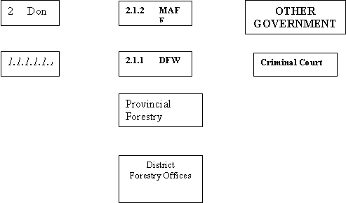
Flow Chart of Forest Information in Cambodia
1.1.1.1.1 R G C
![]()
 PUBLIC AND MEDIA
Somchay Sanonty
Deputy Head of Planning Division
Ministry of Agriculture and Forestry
Lao People's Democratic Republic
INTRODUCTION
The Lao People's Democratic Republic (Lao PDR.) is located in Southeast Asia, between latitudes 13'50" and 22'30" N, and longitudes 100'10" to 107'40" E. The country shares borders with China to the North, Myanmar to the Northwest, Thailand to the West, Cambodia to the South, and Viet Nam to the East. The total land area is 236,800 square km, the population in 1998 was estimated at 5.2 million with an annual growth rate of 2.76 percent. Population density is approximately 22 people per square km.
Elevation ranges from 80 meters, where the Mekong River leaves the country in the extreme South, to 2820 meters, the summit of Phobia Mountain in Xiangkhuang province. 79 percent of the country is regarded as mountainous area.
The climate is dominated by the monsoon, with distinct wet and dry seasons. Most rain falls during May to September, when the prevailing wind blow from south to west. Annual rainfall ranges from 1000 mm in the north to 300 mm in the South. The dry season begins from October to April, and is characterized by winds that blow from the Northeast.
The Mekong river flows through the country. It reaches Lao PDR from China in the Northwest, where the country also shares borders with Myanmar and Thailand. It enters Lao PDR eastward to Luang Prabang, then flows south to regions bordering Thailand, Viet Nam, and Cambodia.
FOREST RESOURCES
Lao PDR is considered to have a large area of land covered with natural forest, compared with most Southeast Asian countries. The natural forest plays a significant role in socio-economic development and needs proper management. Available data indicate that natural forest covers about 11 million hectares, around 47 percent of the total land area.
During the past 30 years there has been a significant decline in forest due to population pressures, and associated shifting cultivation, agricultural expansion and logging for commercial purposes. The Lao government is attempting to protect the remaining forest resources in order to maintain ecological balance.
Most of the forest is mixed deciduous forest, which covers 35 percent of the country. About 5 percent are Dipterocarp forest and 5 percent is dry evergreen forest. The remaining forest area is coniferous and mixed-coniferous forest.
The vegetation comprises various species of plants, ranging from small short-lived herbs to long-living trees. At low and medium altitudes (100-500 meters) species of Dipterocarp, have commercial value as hard wood. At higher elevations numerous medium size broad-leaved trees, are of commercial value as are tropical pines species and other important coniferous species such as Araucaria cunninghamia. Non-timber forest products also occur as a wide range of the species, including bamboos, rattans, cardamoms, benzoin, latex, bark resin, gum etc. The forests of the Lao PDR also harbour uncountable species of fauna including large mammals such as elephants, wild cows and buffalo.
The forest of the Lao PDR is broadly classified into four categories as follows:
Evergreen Forest 3,400,000 ha
Mixed deciduous Forest 5,680,000 ha
Deciduous Forest 1,600,000 ha
Other 480,000 ha
Total 11,160,000 ha
POLICY AND STRATEGY DEVELOPMENT
Sustainable forest management of the vast tropical forest resources in Lao PDR - through selective logging, establishment of forest plantations and attempts to stabilize shifting cultivation - is a cornerstone of Government policy. In 1989 the government of Lao has laid down a basic forest policy and guidelines as follows:
Biological resources of the present forest must be protected, by an approach emphasising people's participation.
Resource use values of the forests should be balanced with conservation.
Afforestation, production and forest management must be linked with food production, and encompass provisions for alternatives to shifting cultivation.
Increased forest cover, up to 70 percent of the total land area, by giving priority to annual regeneration systems.
To fulfil the strategy guidelines for the year 2000, Lao PDR developed a Tropical Forest Action Plan (TFAP) in 1990 and this was endorsed by the Lao government in 1991.
In 1994, the Ministry of Agriculture and Forestry (MAF)/Department of Forestry (DoF) formulated a strategy proposal for the forestry sector 1995-2000. In 1997 the DoF drafted a Vision 2020 in order to translate Government policy into strategies. The following priorities were outlined:
Development of viable alternatives to shifting cultivation and gradually decrease unsustainable upland farming.
Allocation of land to rural families and enterprises to encourage sustainable plantation development.
Survey the national forest resource and set up appropriate system for forest management.
Management of biodiversity and conservation areas and protection of priority watershed areas.
Development of an appropriate and competitive forest industry.
Strengthening human resource development.
Strengthening forest research strategies.
To achieve the goals of forest strategies and policy the Government of Lao has undertaken the following measures:
revised forest land use categories;
developed procedures for land and forest allocation;
developed procedures to stabilize shifting cultivation;
promote sustainable forest management and conservation; and
promotion of forest plantations. Targeted annual planting programme of 20,000 ha and the target to be achieved by the year 2020 is approximately 500,000 ha.
Legal Framework
To use the natural resource in a sustainable way, the government of Laos has issued many decrees, which relate to the utilization of natural resources. In 1996, the Forest Law was enacted by government. About 35,000 copies of the forest law have been published and over 15.000 copies have been distributed to ensure that the implementation of the law is successful.
The Department of Forestry has drafted various regulations and technical guidelines such as:
sustainable plantation development regulations;
conservation and wildlife management regulations;
village forest regulations;
C&I for sustainable forest management; and
Code of Practice development.
Shifting cultivation stabilization
The Lao government places high priority on reducing/stabilizing shifting cultivation in the country to protect forest resources and the environment. One of the 8 priorities of the government aims to protect natural resources and to increase living standards for rural people. There are many experimental activities on shifting cultivation stability, using many methods and supported by bilateral donors.
Forest land use planning and land allocation
The Lao PDR has large areas of agricultural and forest land. However, large areas have been degraded by slash and burn agriculture, forest fires and commercial logging. With a rapidly increasing population more land is needed for agricultural production. These days agriculture is limited to flat lands.
The Forest Law provides a clear definition of forests, which stipulates: The Lao government determines which parcel of land will be designated as forestlands such as:
Protection Forest
Protection forest is forest and forest land classified for protection of the watersheds and prevention of soil erosion. It is also includes areas of forest land significant for the national security, areas for protection against natural disasters, and for the protection of the environment, etc.
Conservation Forest
Conservation forest is forest and forest land classified for the purpose of protecting and conserving animal species, plant species, natural, and various other, features which have historical, cultural, tourism, environmental, educational, or scientific research, value.
Production Forest
Production forest is forest and forest land classified for the purpose of satisfying the requirements of natural, economic and social, development and of people's livelihoods. Production forest is designated to provide timber and other forest products on a sustainable basis and without significant negative environment impacts.
Regeneration Forest
Regeneration forest is a young fallow forest classified for the purpose of regeneration and maintenance so that it increases in maturity toward a state of natural equilibrium.
Degraded Forest land and Barren land
Degraded forest land is forest which has been heavily damaged including land without forest on it, or barren land designated to be reforested, or allocated to an individual or organization for tree planting, permanent agro-silvo-pastoral production or for other purpose in accordance with national economic development plans.
Recently, Land Use Planning and Land Allocation (LUP/LA) committees have been created at the national level and in all provinces and districts to supervise and co-ordinate the implementation of the LUP/LA programme, while the actual field work is carried out by trained agricultural and forestry staff from DoF. This unit has the overall responsibility for training and monitoring activities with regard to the LUP/LA programme.
In implementing land use planning practices, land for different purposes is being allocated to villagers, households or communities. Land allocation is a participatory process in which villagers make the allocation decisions. The demarcation of land unit boundaries prepared the process for its final phase - actual land allocation - land tenure certificates, for each participant, are to be issued by land allocation committees.
Although increasing activities in LUP/LU are carried out in the province and districts, very little information on the programme is available at central level, except for overall figures on land allocated to villagers and communities. All of the vast amounts of information and data gathered during the land-use planning process is only accessible to a limited number of people on sketch-maps and field notebooks and could easily be lost in the future.
Currently, the main projects/programmes supporting the land use planning and land allocation activities of the government are the Lao-Swedish Forestry Programme (LSFP) with sub-programmes in Sayaboury, Luang Prabang, Savannakhet and Saravane; and the Nam Ngum Watershed Management and Conservation Project supported by GTZ in Xiengkhouang. Both projects are involved in the conceptual development and model building of the national land use planning and land allocation programme.
RECENT STATE OF DATA COLLECTION AND DATA AVAILABLE
There is no forest information system yet in Lao PDR. Consequently, the quality of existing data on forest resources, production and consumption of various wood products, including industrial products is not uniform. Data collection is done by different organizations or projects to meet their own objectives. So valuable data are available from many different offices/projects as follows:
Forest Inventory and Planning Center (FIPC)
Valuable data on forest resources at national level is available for the whole country. Forest inventory activities carried out by the National Forest Inventory (NFI) sub-project. The Forest Inventory and Planning Center, previously called NOFIP, under National Agriculture and Forestry Research Institute (NAFRI) is responsible for implementation of the National Forest Inventory and manages all related databases. In preparation for selected land use planning exercises, local forest inventories and classifications have been carried out and this data is stored in digital form, such as GIS. Additional data on forest cover had been gathered and interpreted by NFI sub-programmes within FIPC and the working scale is 1:100,000. The focus of the work nevertheless lies on macro-scale forest inventories.
Forest Resource Conservation Division
Within the Forest Resource Conservation Division a small GIS unit has in the past mainly catered for needs in mapping and data management for watershed management projects, wildlife protection and biodiversity conservation e.g. in National Biodiversity Conservation areas.
Forest Management and Conservation Project (FOMACOP)
A village forestry model has been developed since 1996. This project will be finalized in September 2000. The village forestry model in FOMACOP is defined as a partnership between organized villages and the state for the sustainable management of designated forests. Conceptually it means the empowerment of villagers by strengthening their capacity and motivation and by giving them the authority to protect and manage forests and to benefit from their efforts. This village forestry system has been carried out in conservation forests, protection forests and production forests mainly emphasizing timber and non-timber forest products. The village forestry model will be promoted as a major system for sustainable forest management in Lao PDR. The activities of village forestry cover several aspects of rural development. While paying attention to the activities related to forest management, it is envisaged that village forestry in FOMACOP be considered to be "community forestry" on "village land" through fixed group participation.
Statistics and Planning Unit
A small statistics and planning unit working with both inadequately qualified staff and substandard technical equipment has recently been established. This unit, within the Planning Division of the DoF, mainly derives data from annual and quarter reports from provincial forest sectors and from data gathered by the GIS unit within FIPC. The amount of geographic data being handled is very limited and basically restricted to countywide overview maps.
The data management facilities in this case are used for a different purpose, which is mainly a compilation of statistical data to be made use of for reports and planning documents for political decision-makers.
Protection and conservation forest
National Biodiversity Conservation Areas (NBCAs)
In 1993 the Lao Government issued Prime Ministerial Decree No 164 proclaiming 20 NBCAs through out the country, totalling about 3.313.597 ha. Due to lack of fund to implement, not all of these have yet been completely surveyed to enable planning management.
Table 1. Current framework of donor support to the NBCA system of the Lao PDR
No. |
Name |
Area (in ha) |
Supported by |
1 |
Nam Phoui |
191,000 |
Sida/IUCN through LSFP Phase IV |
2 |
Nam Ha |
69,000 |
WCS |
3 |
Phou Dene Dinh |
220,000 |
under consideration by EU |
4 |
Phou Loei |
150,000 |
RJCN/DANIDA WCS) |
5 |
Nam ET |
170,000 |
IUCN/DANIDA |
6 |
Nam Xain |
70,000 |
no support |
7 |
Phou Khao Khoay |
200,000 |
LSFP Phase IV /IUCN + ADB |
8 |
Nam Kading |
169,000 |
no support |
9 |
Phou Hinboun (Limstone) |
150,000 |
GEF/FOMACOP |
10 |
Nakai Nam theun |
323,000 |
GoUWB/IUCN |
11 |
Hin Namno |
82,000 |
WWF |
12 |
Phou Phanang |
70,000 |
Canada fund |
13 |
Xe sap |
133,000 |
FOMACOP |
14 |
Phou Xang he |
109,000 |
I,SFP Phase IV /IUCN |
15 |
Xe Bang Nouan |
150,000 |
LSFP Phase IV IIUCN |
16 |
Phou Xiang Thong |
120,000 |
The Netherlands/TUCN BCP |
17 |
Dong Hua Sao |
110,000 |
The Netherlands/IUCN BCP |
18 |
Xe Piane |
240,000 |
FOMACOP/GEF/FINIDA and DANIDA |
19 |
Dong Ampham |
200,000 |
Limited support from WWF |
20 |
Dong Phouvieng |
197,000 |
1 FOMACOP |
Source:Department of Forestry
Wildlife conditions
Lao PDR has a high diversity of mammals, reptiles, birds and other vertebrate and invertebrate species, but very little information has been published or otherwise summmarised on the current status of individual species. Wildlife play very important roles as natural resources, which provide economic and biological values to humans.
Presently, wildlife populations in Lao PDR have declined due to hunting, habitat destruction by shifting cultivation, agriculture expansion, and resettlement. The government of Lao has tried hard to overcome this problem. Declaration of 20 NBCAs reflects the government of Lao effort in this regard.
Watershed management
ABOUT 79 PERCENT OF THE TOTAL AREA IN LAO PDR ARE MOUNTAINOUS AND most lao people are living on flat land along the riverside. About 80- 85 percent live in the countryside and are farmers. Therefore watershed protection and management are very familiar to them, by learning from experiences. The forestry sector cannot alone manage to achieve watershed goals. Recently the ministry of agriculture and forestry has developed an agriculture & forestry strategy, which highlights integrated upland farming systems.
Production forest
Although natural forest management requires a careful balancing of short term benefits (through logging mature trees) and long run sustainability (through investment in improving regeneration and tending), harvesting has become the primary consideration with regard to forest management in Lao PDR. There are no operational management plans and logging quotas for each province are worked out based on assumptions that are not adequately validated.
The wood-based industry is composed mainly around the sawmill industry. In 1996 there were 100 registered sawmills. Most of the mills are relatively small, average production capacity of about 3,000-4,000 m3 in terms of output. The total capacity of the sawmills is estimated at about 300,000-400,000 m3, but due to low capacity utilization rates the annual official production has been around 250,000 m3 during the mid 1990s.
There are two plywood mills with a combined capacity of 100,000 m3. There are no pulp and paper mills in Lao PDR. Downstream processing is still relatively limited comprising mainly parquet production for export and furniture manufacture for the domestic market. The number of parquet operations in 1996 is estimated at [no figure given - ed.] compared with about 25 in 1989. The number of wooden furniture manufacturers in 1996 is estimated [no figure given - ed.] compared with in 1989.
The volume of these operations has been estimated at 200,000-250,000 m3, which implies that annual production of sawn-wood would be about 500,000 m3 at present.
The key problems with regard to existing practices are shortages of material and human resources. Absence of appropriate technologies for logging and regeneration are the main problems with regard to production forest.
Non-wood forest products
Extraction of non-wood forest products is a relatively small-scale activity and commercial exploitation is limited to a few products such as pine resin, benzoin, stick lac, agarwood, cardamom, and some of the medicinal plants.
The main problems with regard to existing non-wood forest product management practices are:
Harvesting and processing are very traditional and there has been no effort to refine the technologies and to enhance local value addition;
No information is available on level of sustainable production and how output could be enhanced through augmenting and managing regeneration. While plantation type approach is feasible in the case of certain species, information is particularly lacking with regard to multiple use management systems;
Market information, especially the final destination of the products, the prices in different markets, the margin extracted by intermediaries at different stages of transactions, etc. are not available.
Regeneration forest
Forest plantation
The government has strongly promoted reforestation and tree planting activities, with an aim to increase forest cover year by year. Presently forest cover is about 47 percent of land area, by the year 2005 forest cover is planned to be 51% (equating to 12,076,800 ha) and in the year 2010 is planned to reach up to 55% (13,024,000 ha). All tree planting activities are carried out by villagers, government, or private companies. June 1, each year is declared a National Tree Planting Day.
Table 2. Annual forest plantation development
Year |
Area planted (ha) |
Remarks |
1975 -80 |
405 |
|
1981- 85 |
1,384 |
|
1996-89 |
1,257 |
|
1990 |
716 |
|
1991 |
1,359 |
|
1992 |
901 |
|
1993 |
2,219 |
|
1994 |
3,798 |
|
1995 |
8,828 |
|
1996 |
11849 |
|
1997 |
12290 |
|
1998 |
9,030 |
|
1999 |
6,353 |
|
2000 |
20,000 |
Planned planting |
Total |
81,025 |
The key problems are:
absence of information on the choice of species, especially site-species matching;
lack of standardization with regard to seed sources, seed technology, nursery and planting practices; and
inadequate data on growth rates of indigenous species and consequently difficulty in developing various management practices and determining their economic viability.
CONCLUSIONS
As mentioned above, a substantial amount data e.g. on forest resources has been compiled in FIPC and elsewhere on the macro-level for planning and monitoring purposes on provincial, national or basin-wide level.
What is presently missing is the storage and interpretation of data on land-use and natural resources management on local or micro-level. That is, at the community and possibly District level. Most of the information needed has already been gathered during participatory land use planning and land allocation exercises. This data needs to be dealt with differently from the macro-scale inventories and merits a specific unit entirely dedicated to the data management for the local level.
There are many projects that are linked to data collection at local level such as FOMACOP, FORCAP, NTFP project and others projects supported by different Donors, but all projects just develop the models, methodologies, techniques and etc. Now some projects have been evaluated, decisions and action need to be taken on models to be implemented in the near future.
So the major obstacles on the process of the planning and implementation in Lao PDR are:
There are many problems concerning forest survey (inventory), which provides basic information for forest management planning:
Numbers of forest surveyors, who are responsible for this field, are still very few, especially at district level.
No botanical specialists (Lao forest consists of many species, including a lot of unknown species).
Area condition is very bad (no accessible roads).
Forest condition is not uniform.
Field season is very short (field data collection can only be done in 4 or 5 months a year).
Problems concerning forest management planning are:
Knowledge of decision-makers in forest management plan is poor.
Volume increment per tree, per stand, or per forest, has not been researched.
Forest regulation is not completed yet.
The need of timber is very high, but natural forest has a low stand volume.
Problems on implementation of forest management plans are:
lack of funds especially private sector investment;
lack of experienced staff; and
lack of modern instruments.
![]()
![]()
![]()