AQUASTAT - FAO's Global Information System on Water and Agriculture
Angola
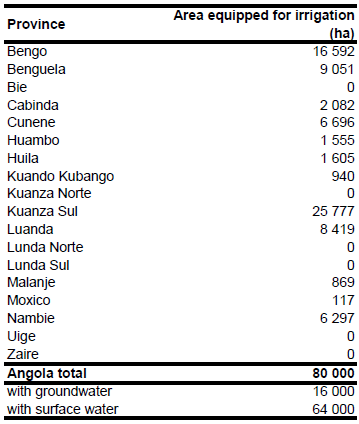
Area equipped for irrigation is estimated at about 80 000 ha. The figures refer to year 1975 but are believed to be still valid [AO01]. In contrast, area equipped for irrigation was 340 478 ha in year 2005 according to a more recently published assessment [AO02]. In any case it is sure that large parts of this area are currently not in operation and area actually used for irrigation in year 1997 was estimated at 35 000 ha [AO01]. Differences may also be explained by the use of different definitions of irrigated land in [AO02] as compared to the FAO-definitions. Area equipped for irrigation per province was computed therefore by scaling the sum of area under irrigation and the area partially under irrigation given in [AO02] (in total 340 478 ha) to the area equipped for irrigation reported by FAO AQUASTAT (80 000 ha). This procedure maintained the regional differences reported in [AO02] and the total area reported in [AO01]. The irrigated area per province estimated that way is visible in the table below and also can be downloaded as Angola irrigation areas in PDF or Angola irrigation areas in Excel.
Irrigated area was distributed to 11 schemes indicated on an irrigation map [AO03] and to 7 schemes derived from an inventory of irrigation schemes [AO04]. Additionally a zone along the coastline and the southern border to Namibia, in which irrigation is concentrated, was digitized from the same map and irrigated areas were assigned to cultivated areas in that zone as digitized from satellite imagery [AO05]. Irrigated areas was then distributed to irrigation projects listed in [AO02] and described in these report as “in operation”. To locate these irrigation projects a geographical name server was used.
The information on water sources for irrigation is also very week. In year 1974 all irrigation was from surface water [AO01]. However, according to the SWECO Grøner assessment use of groundwater for irrigation is important in the coastal area and in the southwestern provinces, especially in the basins of Dande, Bengo, Cuanza, Longa, Queve, Cunene and Cubango were water is taken from the alluvium after rivers have dried up [AO02]. Based on this qualitative information area equipped for irrigation with groundwater was estimated at 20 percent.
References
[AO01]: FAO. 2005. AQUASTAT country profile Angola. FAO, Rome, Italy.
[AO02]: SWECO Grøner. 2005. A rapid water resources and water use assessment. National Water Sector Management Project, activity C, Final Report to the National Directorate of Water, SWECO Grøner, Stockholm, Sweden, 259 pp. + appendix.
[AO03]: MINADER, FAO, PNUD, Banque mondiale, PAM. 2004. Review of agricultural sector and food security strategy and investment priority setting (TCP/ANG/ 2907) – Figure 1 of working paper n° 9: Irrigated agriculture development.
[AO04]: MINADER, FAO, PNUD, Banque mondiale, PAM. 2004. Review of agricultural sector and food security strategy and investment priority setting (TCP/ANG/ 2907) – Annex 1 of working paper n° 15.
[AO05]: Earth Satellite Corporation. 2004. Landsat GeoCover (2000/ETM+) Edition Mosaics, tiles 071-677, 071-678, 071-679, 071-680 and 071-687. Sioux Falls, USA, USGS (available at http://glcfapp.umiacs.umd.edu:8080).


