AQUASTAT - FAO's Global Information System on Water and Agriculture
Albania
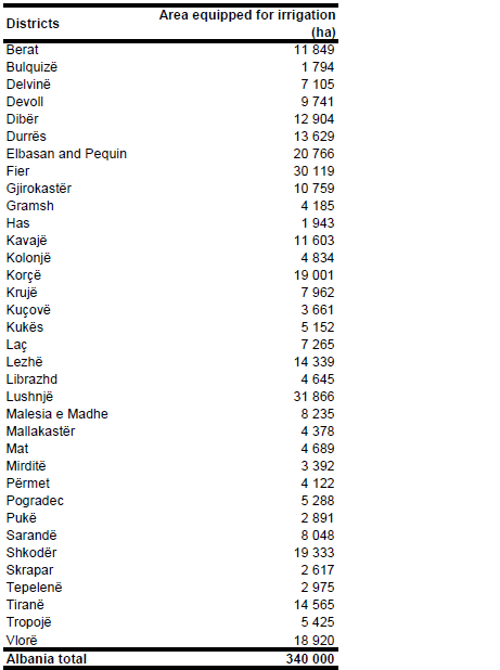
The area equipped for irrigation was about 420 000 ha at the beginning of the 1990’s [AL01], [AL02] and declined to 340 000 ha around year 2000 [AL03], [AL04]. Area equipped for irrigation per district as given for the year 1993 (in total 416 977 ha, [AL01]) was scaled so that the country totals meet the value of 340 000 ha reported to be still present.
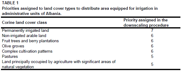
To distribute irrigated area within the districts, irrigated area was assigned to all polygons classified as cultivated land in the CORINE land cover 2000 database for Europe [AL05] using the priority levels reported in Table 1.
The result of this assignment has been in good agreement to other maps showing irrigation infrastructure in Albania ([AL06], [AL07]).The irrigated area per district estimated that way is visible in the table below and also can be downloaded as Albania irrigation areas in PDF or Albania irrigation areas in Excel.
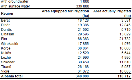
It was reported that irrigation in Albania is from surface water except of 1 000 ha land in hilly regions where water from springs is being used [AL08]. Therefore area equipped for irrigation with groundwater was set to 1 000 ha. Area actually used for irrigation declined from 316 000 ha in 1991 [AL02] to smaller than 80 000 ha in 1994 because many areas faced an urgent need for rehabilitation [AL03]. Due to intensive rehabilitation works the area actually used for irrigation increased again to 120 000 ha in 1996 and about 250 000 ha in 1998 [AL08]. For this inventory, area actually irrigated per county was computed as average of the AAI reported for the period 2001-2009 [AL09], resulting in a total AAI of 110 712 ha.
References
[AL01]: World Bank. 1994. Albania - irrigation rehabilitation project. Staff Appraisal Document, Report no. 12609-ALB, World Bank, Washington, US, http://www.worldbank.org, 29/08/2005.
[AL02]: FAO. 1992. Albania - irrigation subsector review. Report no. 93/92 CP-ALB 4 SR, FAO Investment Centre, Rome, Italy.
[AL03]: World Bank. 2003. Water resources management in South Eastern Europe. Vol. II: Country water notes and water fact sheets. World Bank, Washington, http://www.worldbank.org, 29/08/2005.
[AL04]: FAO. 2012. AQUASTAT Country Statistics. Italy.
[AL05]: EEA. 2005. Corine land cover 2000 - vector by country (CLC2000), version 1. http://dataservice.eea.europa.eu/dataservice/metadetails.asp?id=667, 29/08/2005.
[AL06]: Toepfer, H. 1993. Die Bewässerungslandwirtschaft und Nahrungsmittelproduktion in Albanien. Irrigation map (Figure 1) on p. 107, In Popp, H. & Rother, K. eds. Die Bewässerungsgebiete im Mittelmeerraum, Passau, Germany, Passavia Universitätsverlag.
[AL07]: National Environmental Agency. 1994. Albanian State of the Environment Report: 1993-1994. Map: Water reservoir and irrigation areas, http://enrin.grida.no/htmls/ albania/soe/htmls/94/html/alba0.htm, 07/07/2006.
[AL08]: World Bank. 1999. Albania - second irrigation rehabilitation project. Project Appraisal Document. Report no. 19242-ALB, World Bank, Washington, http://www.worldbank.org, 12/08/2009.
[AL09]: Institute of Statistics. 2011. Irrigated area by county in ha. http://www.instat.gov.al/graphics/doc/tabelat/Treguesit Ekonomik/Bujqesia/BUJ 2010/ 16.xls, 15/10/2011.


