AQUASTAT - FAO's Global Information System on Water and Agriculture
Argentina
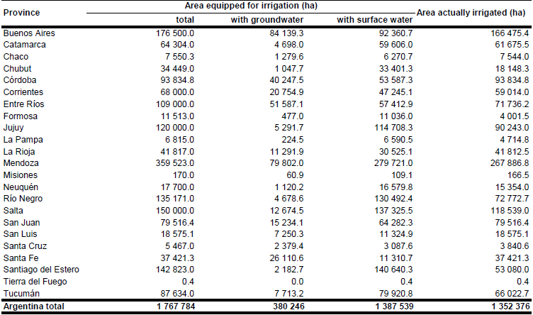
Area equipped for irrigation in 1997 was reported at 2 328 829 ha, but 778 596 ha were under rehabilitation so that only 1 550 233 ha were actually used [AR01]. According to the agricultural census, the area actually irrigated was 1 065 000 ha in 1970, 1 246 748 ha in 1988, 1 437 275 ha in 1995 [AR02] and 1 355 601 ha in 2002 [AR03]. Sub-national statistics were available by province and district but referred to the area actually irrigated. Area equipped for irrigation was therefore estimated by selecting the maximum of the areas actually used for irrigation in the years 1995 and 2002 [AR02], [AR03], [AR04]. Total area equipped for irrigation estimated that way was summing up to 1 767 784 ha. Area equipped for irrigation by district was computed by scaling the area actually irrigated reported for the year 2002 [AR03] so that the sum of area actually irrigated by province was equal to the figures reported the table below. The irrigated areas both by province and by district can be downloaded as Argentina irrigation areas in PDF or Argentina irrigation areas in Excel (two sheets).

To distribute irrigated area within the districts irrigated area was assigned to irrigated areas digitized from irrigation maps [AR05] and to areas classified as cropland in the GLC2000 land cover map for South America [AR06] located within polygons digitized from province maps showing the irrigation districts [AR07]. If districts were located completely outside the irrigation districts, area equipped for irrigation was assigned to all cells classified as cropland.
Area actually irrigated per district was available from the report of the agricultural census 2002 [AR03]. Area irrigated with groundwater was estimated for each district based on the total number of farms irrigating by using different sources of water as reported by the agricultural census 2002 [AR03]. Percentage of AEI irrigated with groundwater was computed as 100 * NR_FARMS_GW / (NR_FARMS_GW + NR_FARMS_SW) where NR_FARMS_GW was the number of farms irrigating using groundwater and NR_FARMS_SW was the number of farms irrigating using surface water. The total area irrigated with groundwater computed this way was 323 415 ha or 24 percent of the total irrigated area reported by the census data base. This is close to the estimates reported by the AQUASTAT country profile for year 1999 (26 percent).
References
[AR01]: FAO. Unpublished. AQUASTAT questionnaire Argentina received in 1999 and available in the AQUASTAT library.
[AR02]: FAO. 2000. Irrigation in Latin America and the Caribbean in figures. FAO, Rome, Italy.
[AR03]: Instituto Nacional de Estadística y Censos (INDEC). 2006. Censo Nacional Agropecuario 2002. Online data base, available at http://www.indec.mecon.gov.ar/, 10/08/2006.
[AR04]: Morábito, J. 1997. Introducción al Riego. El Riego en el mundo, Argentina y Mendoza. Instituto Nacional de Ciencia y Técnica Hídricas (INCyTH) - Universidad Nacional de Cuyo.
[AR05]: Instituto Nacional de Technologia Agropecuaria. 1986. Aptidud y uso actual de las tierras Argentinas. Secretaria de Agricultura, Granaderia y Pesca, Buenos Aires, Argentina.
[AR06]: Eva, H.D., de Miranda, E.E., Di Bella, C.M., Gond, V., Huber, O., Sgrenzaroli, M., Jones, S., Coutinho, A., Dorado, A., Guimarães, M., Elvidge, C., Achard, F., Belward, A.S., Bartholomé, S., Baraldi, A., De Grandi, G., Vogt, P., Fritz, S. & Hartley, A. 2003. The land cover map for South America in the year 2000. GLC2000 database, European Commision Joint Research Centre, available at http://www-gem.jrc.it/glc2000, 10/08/2006.
[AR07]: Dirección Nacional de Recursos Hídricos. 1995. Areas irrigadas de la Argentina. Identificación y localización de las principales areas bajo riego. Subsecretaría de Recursos Hídricos, Buenos Aires, Argentina.


