AQUASTAT - FAO's Global Information System on Water and Agriculture
Botswana
Area equipped for irrigation is reported to be 1 438.6 ha [BW01]. The figures refer to year 2002.
The location and command area of 11 irrigation projects was available from the FAO-irrigation map of Africa [BW02]. The command areas are summing up to 1 855 ha and were scaled to meet the statistics reported for the specific regions. However, no irrigation project was known for the Francistown Region in the North-East of the country. Therefore two areas close to Francistown, that are likely to be irrigated (one of it is a center pivot scheme), were digitized from satellite imagery [BW03]. The irrigated area per region estimated that way is visible in the table below and also can be downloaded as Botswana irrigation areas in PDF or Botswana irrigation areas in Excel.
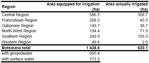
44.3 percent of the total area equipped for irrigation was using groundwater while 3.9 percent was using water from mixed sources. By assuming a 50 percent contribution of groundwater in mixed water area equipped for irrigation with groundwater is therefore 665.4 ha. Area actually irrigated was 620.1 ha (43 percent of total area equipped for irrigation) in the dry season 2002 [BW01].
References
[BW01]: FAO. 2003. Botswana. National irrigation policy and strategy – Irrigation situation analysis. Report November 2003 (second draft) by Stephens T.F. TCP/BOT/0065 (A).
[BW02]: FAO. 1987 (updated in 2005). Irrigated areas in Africa. FAO, Rome, Italy.
[BW03]: Earth Satellite Corporation. 2004. Landsat GeoCover (2000/ETM+) Edition Mosaics, tiles 071-694 and 071-695. Sioux Falls, USA, USGS (available at http://glcfapp.umiacs.umd.edu:8080).


