AQUASTAT - FAO's Global Information System on Water and Agriculture
Chile
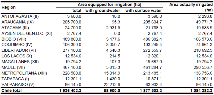
Area equipped for irrigation for each of the 13 regions was derived from the AQUASTAT country report ([CL01]). The data refer to year 1996. AEI was downscaled to the municipality level based on the land use statistics reported by the agricultural census 2007 ([CL02]). AEI was computed as the sum of AAI reported for each municipality (1 084 382 ha in total) and a second area calculated by scaling the difference between AAI and total cultivated land ([CL02]) for each district so that AEI per region was similar to AEI per region reported in the AQUASTAT country report ([CL01]). In regions where AAI reported for year 2007 was larger than AEI reported by AQUASTAT for year 1996, AEI was set to AAI reported for year 2007. This resulted in a total AEI of 1 936 402 ha. The irrigated areas by region are shown in the Table below. The irrigated areas both by region and by municipalities can be downloaded as a Chile irrigation areas in PDF or Chile irrigation areas in Excel (two sheets).
The boundaries of the most important irrigation districts and the location of large public irrigation projects were digitized from several maps available in the AQUASTAT-library ([CL03], [CL04], [CL05]). The remaining area equipped for irrigation was distributed equally over the most suitable grid cells using the USGS land cover classification map [CL06].
Area irrigated from groundwater was 58 900 ha (3.2 percent of total AEI) in year 1999 ([CL01]). An inventory of registered irrigation schemes indicating the source of irrigation water was available ([CL07]) but covered only 1 010 113 ha and listed only 3 800 ha of irrigation areas supplied by groundwater. Therefore an inventory of registered wells ([CL08]) showing the location of 4 980 wells used for irrigation was used to define irrigated area from groundwater for each district by assigning a constant irrigated area to each well so that the total irrigated area from groundwater was equal to the 58 900 ha reported by FAO AQUASTAT. Area actually irrigated was derived from statistics collected by the agricultural census 2007 ([CL02]).
References
[CL01]: FAO. 2000. AQUASTAT country profile of Chile. FAO, Rome, Italy.
[CL02]: INE. 2009. Resultados Censo Agropecuario 2007. Instituto Nacional de Estadísticas (INE), Santiago de Chile, Chile, http://www.censoagropecuario.cl/, 17/08/2009.
[CL03]: El Mercurio. 1984. Las Nuevas Obras de Regadio, 24/06/1984.
[CL04]: Unknown source. Map of irrigation projects, grey literature in AQUASTAT-library.
[CL05]: Ministerio de Obras Publicas Chile. 1965. Inventario de Obras Publicas - Riego.
[CL06]: USGS. 2001. Global Land Cover Characterization, map version 2, http://edcdaac.usgs.gov/index.html, 10/08/2006.
[CL07]: Dirección de Obras Hidráulicas. 2009. Catastro complete de Obras de Riego. Dirección de Obras Hidráulicas, Ministerio de Obras Públicas, Santiago, Chile, http://www.doh.gob.cl/images/stories/infraestructura\_de\_riego.xls, 13/08/2009.
[CL08]: Comisión Nacional de Riego. 2008. Sistema de Informacion Integral de Riego (E-SIIR). Comisión Nacional de Riego (CNR), Santiago, Chile, http://esiir.cnr.cl/, 13/08/2009.


