AQUASTAT - FAO's Global Information System on Water and Agriculture
Cyprus
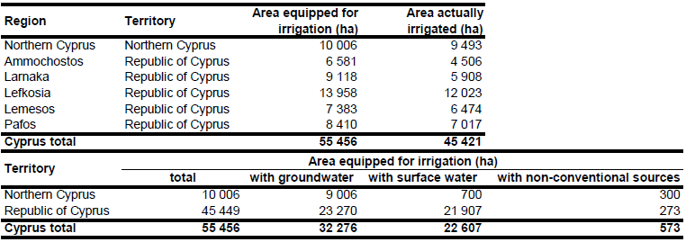
Area equipped for irrigation per municipality in the Republic of Cyprus (in total 45 449 ha) was derived from the report of the agricultural census 2003 [CY01] while area equipped for irrigation in per district in Northern Cyprus (in total 10 006 ha) was derived from a report published in 2005 [CY02]. Therefore, AEI for the whole island of Cyprus was 55 456 ha. The irrigated area by region is visible in the table below and the irrigated area both by region and by district can be downloaded as Cyprus irrigation areas in PDF or Cyprus irrigation areas in Excel (two sheets).
Irrigated areas were extracted from the Corine 2000 land cover data base for Europe [CY03] or digitized from a land-use map produced in 1975 [CY04]. This map also shows irrigated areas in the Northern part of Cyprus. In addition, eleven government schemes were digitized from a recent inventory [CY05].
For the Republic of Cyprus it was assumed, that 51.2 percent of the area is irrigated with groundwater, 48.2 percent with surface water and 0.5 percent with water from nonconventional sources [CY06]. Based on the amount of water consumption from different sources reported in [CY02] we estimated that 90 percent of the AEI in Northern Cyprus was irrigated with groundwater, 7 percent with surface water and 3 percent with water from nonconventional sources. For the whole island of Cyprus, his resulted in 32 276 ha AEI irrigated with groundwater, 22 607 ha irrigated with surface water, and 573 ha irrigated with water from non-conventional sources. Area actually irrigated for the Republic of Cyprus was derived from the agricultural census report 2003 (in total 35 928 ha) while the area actually irrigated for Northern Cyprus (in total 9 493 ha) was computed as average of annual irrigated areas reported for the period 2001-2005 [CY07].
References
[CY01]: Republic of Cyprus. 2006. Census of agriculture 2003. Statistical Service, Republic of Cyprus http://www.mof.gov.cy/mof/cystat/statistics.nsf/index\_en/index\_en?OpenDocument, 02/03/2011.
[CY02]: Elkiran, G., Ergil, M. 2006. Integrated water resources planning and management of North Cyprus: case study on water supply and demand including drought conditions. International Conference on "Water Observation and Information System for Decision Support" Ohrid, Republic of Macedonia, May 23-26, 2006, http://www.balwois.com/cms/index.php, 17/08/2009.
[CY03]: EEA. 2005. Corine land cover 2000 - vector by country (CLC2000), version 1. http://dataservice.eea.europa.eu/dataservice/metadetails.asp?id=667, 29/08/2005.
[CY04]: Savvides, L. 1975. Land use map of Cyprus - Scale 1:250 000. Nicosia.
[CY05]: Savvides, L., Dörflinger, G., Alexandrou, K. 2001. Reassessment of the island’s water resources and demand - the assessment of water demand of Cyprus. Nicosia, Ministry of Agriculture, Natural Resources and Environment, FAO.
[CY06]: FAO. 2011. AQUASTAT country profile of Cyprus, version 1997. FAO, Rome, Italy.
[CY07]: TRNC Ministry of Agriculture and Forestry. 2002-2006. Agricultural structure and production. http://www.tdkb.gov.ct.tr/en-us/%C3%BCstmenu/istatistikler.aspx, 06/09/2012.


