AQUASTAT - FAO's Global Information System on Water and Agriculture
Djibouti
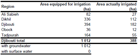
Area equipped for irrigation is 1 012 ha [DJ01]. The figures refer to year 1999. The irrigated area per region estimated that way is visible in the table below and also can be downloaded as Djibouti irrigation areas in PDF or Djibouti irrigation areas in Excel.
No spatial information was available related to the location and extent of irrigation schemes. Therefore arable land was digitized from satellite imagery [DJ02] and the irrigated area distributed to these digitized areas.
Area actually irrigated was 388 ha in year 1999. Irrigation is completely based on groundwater resources [DJ01].
References
[DJ01]: FAO. 2005. AQUASTAT country profile Djibouti, FAO, Rome, Italy.
[DJ02]: Earth Satellite Corporation. 2004. Landsat GeoCover (2000/ETM+) Edition Mosaics, tile 071-295. Sioux Falls, USA, USGS (available at http://glcfapp.umiacs.umd.edu:8080).


