AQUASTAT - FAO's Global Information System on Water and Agriculture
Estonia
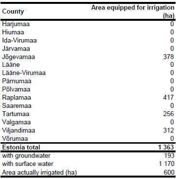
Area equipped for irrigation reached its maximum by the end of the 1970s (14 000 ha), but was reduced to 3 680 ha in 1995 due to the liquidation of the kolkhoz and sovkhoz [EE01]. Area equipped for irrigation per county was available for year 2005 [EE02], the areas sum up to 1 362.7 ha. The irrigated area per county estimated that way is visible in the table below and also can be downloaded as Estonia irrigation areas in PDF or Estonia irrigation areas in Excel.
Maps showing the location of irrigation areas in Estonia were not available, but it was reported that irrigation is mainly used to grow vegetables or to water pastures [EE01]. While the irrigation of pastures was practiced traditionally, the irrigation of early potatoes is mentioned explicitly in a more recent report [EE03]. It was therefore decided to assign 80 percent of the area still equipped for irrigation to polygons classified as non-irrigated arable land (211) or complex cultivation patterns (242) in the Corine 2000 land cover data base for Europe [EE04] and to assign the remaining irrigated area to polygons classified as pastures (231) in the same data base.
Based on the ratio between groundwater abstractions for agriculture, forestry and fishery and total water abstractions for agriculture, forestry and fishery in period 2003-2007 [LV06] area equipped for irrigation with groundwater was estimated at 193 ha (14 percent of total AEI). Area actually irrigated around year 2000 was reported to be 600 ha [EE06].
References
[EE01]: FAO. 2012. AQUASTAT country profile of Estonia, version 1997. FAO, Rome, Italy.
[EE02]: Area equipped for irrigation per county on 01/01/2005, data provided by Mati Tonismae, Chairman of ICID National Committee of Estonia (ESTICID) and Head of the Bureau of Infrastructure, Ministry of Agriculture on 21/02/2006.
[EE03]: Kucera, L. & Genovese, G. (ed.). 2004. Crop monographies on Central European countries – MOCA Study. Joint Research Centre of the European Commission, Directorate General, Institute for the Protection and Security of the Citizen, Agriculture & Fisheries Unit, Ispra, Italy, http://agrifish.jrc.it/marsstat/Crop\_Yield\_Forecasting/MOCA/INDEX.HTM, 07/07/2006.
[EE04]: EEA. 2005. Corine land cover 2000 - vector by country (CLC2000), version 1. http://dataservice.eea.europa.eu/dataservice/metadetails.asp?id=667, 29/08/2005.
[EE05]: Statistical Office of the European Communities (EUROSTAT). 2011. Annual water abstraction by source and by sector. http://epp.eurostat.ec.europa.eu/portal/page/portal/ environment/data/database, 28/11/2011.
[EE06]: Baldock, D., Caraveli, H., Dwyer, J., Einschütz, S., Petersen, J.E., Sumpsi-Vinas, J. & Varela-Ortega, C. 2000. The environmental impacts of irrigation in the European Union. A report to the Environment Directorate of the European Commission, 147 pp., http://ec.europa.eu/environment/agriculture/, 07/07/2006.


