AQUASTAT - FAO's Global Information System on Water and Agriculture
France
The irrigated areas by region (France Hexagon, French Guiana, Guadeloupe, Martinique and Reunion) and by department (for France Hexagon) can be downloaded as France irrigation areas in PDF or France irrigation areas in Excel (six sheets).
France Hexagon, excluding overseas departments
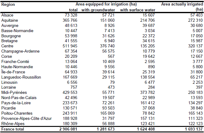
The irrigable area of the country increased steadily from 2 099 700 ha in 1990 to 2 510 410 ha in 1995 and 2 723 700 ha in 2003. The area actually irrigated was lower but increased also from 1 484 840 ha in 1990 to 1 629 580 ha in 1995 and 1 938 730 ha in 2003 [FR01]. According to the agricultural census 2000 the main irrigated crops were maize (56 percent of the irrigated area), vegetables and potatoes (12 percent of irrigated area) and fruits and vines (9 percent of the irrigated area) [FR02]. Area equipped for irrigation was estimated by selecting the maximum of the irrigable area as reported by the EIDER data base by department for the years 1997, 2000 and 2003 [FR03]. For the year 2003 data were available for only 46 of the 96 departments which may lead to an underestimation of the area equipped for irrigation in the remaining 50 departments. Area equipped for irrigation by region and department estimated that way is summing up to 2 906 081 ha. The irrigated area by region is visible in the table below and the irrigated area both by region and by department can be downloaded as France irrigation areas in PDF (page 1-3) or France irrigation areas in Excel (sheet 1 and 2).
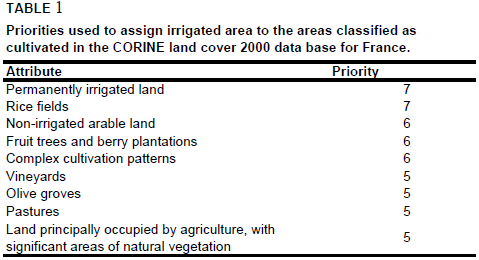
Area equipped for irrigation was distributed within the departments by combining cultivated areas as derived from the Corine 2000 land cover data base for Europe [FR04] and a map published in [FR02] showing the percentage of cultivated land that is irrigated by canton. It was assumed that the density of area equipped for irrigation within the departments is relative to the density of area actually irrigated computed that way. To assure that irrigation is mainly concentrated on arable land, the priority levels shown in Table 1 below were used. The irrigation map for France compiled that way was found to be in good agreement to irrigation maps published in the literature ([FR05], [FR06]).
Area equipped for irrigation with groundwater was computed based on the data collected by the EU farm structure survey 2003 as described before. Area actually irrigated per province was computed as average of AAI reported by the farm structure surveys 2003, 2005, and 2007 [FR01]. Total AAI computed that way was summing up to 1 693 137 ha.
References
[FR01]: Statistical Office of the European Communities (EUROSTAT). 2011. Irrigable and irrigated areas. http://epp.eurostat.ec.europa.eu/portal/ page/portal/agri_environmental_indicators/data/ database, 28/11/2011.
[FR02]: Gleyses, G. & Rieu, T. 2004. L'irrigation en France. État des lieux 2000 et évolution. CEMAGREF, Antony, France, 60 pp.
[FR03]: Institut français de l’environnement (IFEN). 2005. Ensemble Intégré des Descripteurs de l'Environnement Régional (EIDER). CD-ROM, version 2005, IFEN, Orleans, France.
[FR04]: EEA. 2005. Corine land cover 2000 - vector by country (CLC2000), version 1. http://dataservice.eea.europa.eu/ dataservice/metadetails.asp?id=667, 29/08/2005.
[FR05]: Reparaz, A. 1993. Irrigation et agriculture irriguee dans les regions mediterraneennes francaises. Irrigation map (Figure 1) on p. 80, In H. Popp & K. Rother, eds. Die Bewässerungsgebiete im Mittelmeerraum, Passau, Germany, Passavia Universitätsverlag.
[FR06]: Roudié, P. 1985. La France – Agriculture, Forêt, Pêche. Second Edition. Irrigation map on p. 131, Paris, France, 197 pp.
French Guiana
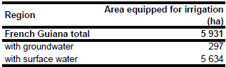
Area equipped for irrigation was 5 931 ha in year 2007, while area actually irrigated was 5 895 ha in the same year [GF01]. The irrigated area is visible in the table below and also can be downloaded as France irrigation areas in PDF (page 4) or France irrigation areas in Excel (sheet 3). No information could be found on irrigated areas on a higher sub-national level.

The irrigated area within French Guiana was distributed based on a map of the major cropping areas in 1979 [GF02].
According to the farm structure survey undertaken in year 2003 the area irrigated from surface water was 4 110 ha, the area irrigated from groundwater was 330 ha and the area irrigated from mixed sources or from the public network was 19 050 ha for the entire area of the French over-sea departments [GF03]. The only department for which the related water use statistics [GF04] explicitly reported a use of groundwater in agriculture was Réunion (5.6 km3/yr groundwater use as compared to 59.3 km3/yr surface water use in year 2005). The main extractions of groundwater were reported in general for the domestic sector. The fraction of municipal water supply from groundwater was about 47 percent for Réunion, 13 percent for Guadeloupe and 7 percent for Martinique [GF04]. Based on these statistics and considering the importance of public networks in irrigation water supply, area irrigated with groundwater was estimated at 5 percent for French Guiana.
References
[GF01]: Ministère de l’agriculture, de l’alimentation, de la pêche, de la ruralité et de l’aménagement du territoire. 2010. AGRESTE, Données en ligne, Structure des exploitations. http://agreste.maapar.lbn.fr/, 06/10/2010.
[GF02]: Centre d'Etudes de Géographie Tropicale. 1979. Atlas des Départements D'Outre-Mer, 23, Utilisation du Sol, major cropping areas.
[GF03]: European Commission. 2009. Ad hoc tables from the farm structure survey. European Commission, EUROSTAT, http://epp.eurostat.ec.europa.eu/portal/page/portal/agriculture/ data/ad_hoc_tables_farm_structure_survey, 12/08/2009.
[GF04]: IFEN. 2009. Ensemble Intégré des Descripteurs de l'Environnement Régional (EIDER). Institut Français de l'Environnement (IFEN), http://eider.ifen.fr/Eider/, 13/08/2009.
Guadeloupe
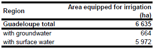
Area equipped for irrigation was 6 635 ha in year 2007, while area actually irrigated was 3 583 ha in the same year [GP01]. The irrigated area is visible in the table below and also can be downloaded as France irrigation areas in PDF (page 5) or France irrigation areas in Excel (sheet 4). No information could be found on irrigated areas on a higher sub-national level.
The irrigated area within the country was distributed based on a cropping area map of sugar cane, coffee, fruit trees, vineyards, bushes and orchard lands [GP02].
According to the farm structure survey undertaken in year 2003 the area irrigated from surface water was 4 110 ha, the area irrigated from groundwater was 330 ha and the area irrigated from mixed sources or from the public network was 19 050 ha for the entire area of the French over-sea departments [GP03]. The only department for which the related water use statistics [GP04] explicitly reported a use of groundwater in agriculture was Réunion (5.6 km3/yr groundwater use as compared to 59.3 km3/yr surface water use in year 2005). The main extractions of groundwater were reported in general for the domestic sector. The fraction of municipal water supply from groundwater was about 47 percent for Réunion, 13 percent for Guadeloupe and 7 percent for Martinique [GP04]. Based on these statistics and considering the importance of public networks in irrigation water supply, area irrigated with groundwater was estimated at 10 percent for Guadeloupe.
References
[GP01]: Ministère de l’agriculture, de l’alimentation, de la pêche, de la ruralité et de l’aménagement du territoire. 2010. AGRESTE, Données en ligne, Structure des exploitations. http://agreste.maapar.lbn.fr/, 06/10/2010. [GP02]: Instituto Geografico de Agostini. 1969. World Atlas of Agriculture. [GP03]: European Commission. 2009. Ad hoc tables from the farm structure survey. European Commission, EUROSTAT, http://epp.eurostat.ec.europa.eu/portal/page/portal/agriculture/ data/ad_hoc_tables_farm_structure_survey, 12/08/2009. [GP04]: IFEN. 2009. Ensemble Intégré des Descripteurs de l'Environnement Régional (EIDER). Institut Français de l'Environnement (IFEN), http://eider.ifen.fr/Eider/, 13/08/2009.
Martinique
Area equipped for irrigation was 6 170 ha in year 2007, while area actually irrigated was 5 291 ha in the same year [MQ01]. The irrigated area is visible in the table below and also can be downloaded as France irrigation areas in PDF (page 6) or France irrigation areas in Excel (sheet 5). No information could be found on irrigated areas on a higher sub-national level.
The irrigated area within the country was distributed based on a map showing irrigable areas in 1977 [MQ02].
According to the farm structure survey undertaken in year 2003 the area irrigated from surface water was 4 110 ha, the area irrigated from groundwater was 330 ha and the area irrigated from mixed sources or from the public network was 19 050 ha for the entire area of the French over-sea departments [MQ03]. The only department for which the related water use statistics [MQ04] explicitly reported a use of groundwater in agriculture was Réunion (5.6 km3/yr groundwater use as compared to 59.3 km3/yr surface water use in year 2005). The main extractions of groundwater were reported in general for the domestic sector. The fraction of municipal water supply from groundwater was about 47 percent for Réunion, 13 percent for Guadeloupe and 7 percent for Martinique [MQ04]. Based on these statistics and considering the importance of public networks in irrigation water supply, area irrigated with groundwater was estimated at 5 percent for Martinique.
References
[MQ01]:Ministère de l’agriculture, de l’alimentation, de la pêche, de la ruralité et de l’aménagement du territoire. 2010. AGRESTE, Données en ligne, Structure des exploitations. http://agreste.maapar.lbn.fr/, 06/10/2010.
[MQ02]:Institut Geographique National. 1977. Atlas des Départements Francais d'Outre-Mer - La Martinique, map 21 (êquipements Agricoles).
[MQ03]:European Commission. 2009. Ad hoc tables from the farm structure survey. European Commission, EUROSTAT, http://epp.eurostat.ec.europa.eu/portal/page/portal/agriculture/ data/ad_hoc_tables_farm_structure_survey, 12/08/2009.
[MQ04]:IFEN. 2009. Ensemble Intégré des Descripteurs de l'Environnement Régional (EIDER). Institut Français de l'Environnement (IFEN), http://eider.ifen.fr/Eider/, 13/08/2009.
Réunion
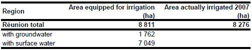
Area equipped for irrigation is 8 811 ha [RE01]. The figures refer to year 2007. The irrigated area is visible in the table below and also can be downloaded as France irrigation areas in PDF (page 7) or France irrigation areas in Excel (sheet 6). No sub-national information on areas equipped for irrigation was available, but it was reported that irrigation is mainly related to sugar cane cultivation and that about 80 percent of the irrigated area is located in the southern part of the island [RE02].
Irrigated areas were digitized from irrigation maps published in [RE02], [RE03] and [RE04]. The shapes of the boundaries of the digitized irrigation areas were improved by using satellite imagery [RE05].
Area actually irrigated in year 2007 was 8 276 ha [RE01]. According to the French farm structure survey undertaken in year 2003 the area irrigated from surface water was 4 110 ha, the area irrigated from groundwater was 330 ha and the area irrigated from mixed sources or from the public network was 19 050 ha for the entire area of the French over-sea departments [RE06]. Groundwater was the source of 9 percent of the water withdrawals in the agricultural sector and of 46 percent of the water withdrawals in the domestic sector in Réunion and year 2007 [RE07]. Based on these statistics and considering the importance of public networks in irrigation water supply, area irrigated with groundwater was estimated at 20 percent for Réunion.
References
[RE01]: Ministère de l’agriculture, de l’alimentation, de la pêche, de la ruralité et de l’aménagement du territoire. 2010. AGRESTE, Données en ligne, Structure des exploitations. http://agreste.maapar.lbn.fr/, 06/10/2010.
[RE02]: Saque, C., Fusillier, J.-L., Choisis, J.-P. 2003. Canne à sucre, état des lieux : irrigation et diversification. Institut National de la Statistique et des Études Économiques (INSEE), Revue économie de La Réunion 114, pp. 15-17 (available at: http://www.insee.fr/fr/insee\_regions/reunion/publi/accueil\_publi.htm).
[RE03]: Centre National de la Recherche Scientifique. 1975. Atlas des Départements Francais d' Outre-Mer, I – La Réunion.
[RE04]: Achtnich, W. 1980. Bewässerungslandbau. Verlag Eugen Ulmer, Stuttgart, Germany.
[RE05]: Earth Satellite Corporation, 2004. Landsat GeoCover (2000/ETM+) Edition Mosaics, tile 071-729. Sioux Falls, USA, USGS (available at http://glcfapp.umiacs.umd.edu:8080/esdi/index.jsp).
[RE06]: European Commission. 2009. Ad hoc tables from the farm structure survey. European Commission, EUROSTAT, http://epp.eurostat.ec.europa.eu/portal/page/portal/agriculture/data/ ad_hoc_tables_farm_structure_survey,12/08/2009.
[RE07]: IFEN, 2009. Ensemble Intégré des Descripteurs de l'Environnement Régional (EIDER). Institut Français de l'Environnement (IFEN), http://eider.ifen.fr/Eider/, 06/10/2010.


