AQUASTAT - FAO's Global Information System on Water and Agriculture
Gabon
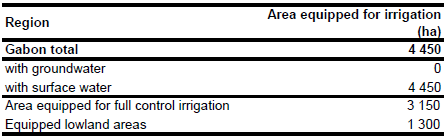
Area equipped for irrigation is 4 450 ha [GA01]. The figures refer to year 1987. However, the figures were confirmed by a recently published report [GA02]. No sub-national statistics on the extent of irrigated lands have been available. The irrigated area estimated that way is visible in the table below and also can be downloaded as Gabon irrigation areas in PDF or Gabon irrigation areas in Excel.
The locations of four irrigation areas were derived from the FAO-map of irrigated areas in Africa [GA03]. The irrigation schemes were then digitized by using satellite imagery [GA04].
Based on the qualitative information contained in the AQUASTAT country report [GA01] and groundwater use in neighbouring countries (Cameroon, Congo) it was assumed that all irrigation is from surface water.
References
[GA01]: FAO. 2005. AQUASTAT country profile Gabon, FAO, Rome, Italy.
[GA02]: FAO. 2004. République du Gabon. Suivi du Sommet mondial de l’alimentation: Cinq ans après. Note sur la stratégie pour le développement agricole national – Horizon 2015.
[GA03]: FAO. 1987 (updated in 2005). Irrigated areas in Africa. FAO, Rome, Italy.
[GA04]: Earth Satellite Corporation. 2004. Landsat GeoCover (2000/ETM+) Edition Mosaics, tiles 071-213, 071-227, 071-673 and 071-677. Sioux Falls, USA, USGS (available at http://glcfapp.umiacs.umd.edu:8080/esdi/index.jsp).


