AQUASTAT - FAO's Global Information System on Water and Agriculture
United Kingdom
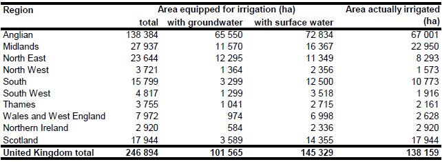
Irrigable area for the United Kingdom was reported at 267 110 ha for the year 1997 and 228 950 ha for the year 2003 [GB01]. The area actually irrigated for the territory of England, where the majority of the total area equipped for irrigation is located, was 155 650 ha in the more dry year 1995 and 147 270 ha in the more wet year 2001 [GB02]. Area equipped for irrigation reported for 10 regions was derived from the statistics of the farm structure survey 2003. AEI for Scotland was set to 17 944 ha according to information on the extent of irrigated potatoes [GB03] and vegetables [GB04]. The main irrigated crops in UK are potatoes and vegetables, which account together for about 79 percent of the total irrigated area [GB02]. About 47 percent of the potato growing area and about 23 percent of the vegetable growing area in UK was irrigated in 2001 [GB05]. Irrigated area per county was estimated by combining harvested crop area derived from the statistics [GB06] and crop specific ratios of irrigated crop area versus total crop area. These ratios were reported for 8 regions for the year 2001 [GB05]. The irrigated areas computed that way for the specific crops were summed up and the irrigated areas by county were scaled so that the total irrigated area by region was equal to the values reported for the area equipped for irrigation for the year 2003. The resulting irrigation densities by county were found to be in good agreement to the spatial distribution of irrigation water demand [GB05] and to densities of points of agricultural water abstractions [GB07]. The irrigated areas by region are shown in the Table below. The irrigated areas both by region and by counties can be downloaded as a United Kingdom irrigation areas in PDF or United Kingdom irrigation areas in Excel (two sheets).
Area equipped for irrigation was distributed within the counties by assigning irrigated area to polygons extracted from the Corine 2000 land cover database for Europe [GB08] classified as non-irrigated arable land (211), fruit trees and berry plantations (222) or complex cultivation patterns (242).
Irrigation water extraction by source of water was available for 8 regions covering the territory of England and Wales [GB09]. The data are related to year 2005. It was assumed that for each region the percentage of AEI irrigated with groundwater was similar to the percentage of irrigation water use extracted from groundwater. In Scotland irrigation is mainly practised for potatoes, vegetables, grass and soft fruits [GB04]. Detailed statistics related to irrigated areas and sources of irrigation water were not available, but case studies for specific watersheds show that irrigation water is extracted from rivers, reservoirs and boreholes [GB03]. Based on the survey data in [GB03] percentage of irrigated area from groundwater sources was estimated at 20 percent for Scotland.
References
[GB01]: Statistical Office of the European Communities (EUROSTAT). 2011. Irrigable and irrigated areas. http://epp.eurostat.ec.europa.eu/portal/ page/portal/agri_environmental_indicators/data/ database, 28/11/2011.
[GB02]: Weatherhead, E.K. & Danert, K. 2002. Survey of irrigation of outdoor crops in 2001 – England. Department for Environment, Food and Rural Affairs (DEFRA) and Cranfield University, Silsoe, UK, http://www.silsoe.cranfield.ac.uk/iwe/projects/irrigsurvey/ irrig_survey.htm, 07/08/2006.
[GB03]: Crabtree, B., Dunn, S., Chalmers, N., and Stalham, M. 2002. Evaluating the economic impact of irrigation controls. Macaulay Land Use Research Institute, Craigiebuckler, Aberdeen, UK, http://www.scotland.gov.uk/Publications/2002/09/15379/10784, 31/08/2009.
[GB04]: Macaulay Land Use Research Institute. 2006. The state of Scotlands farmed environment 2005. http://www.macaulay.ac.uk/LINK/LINK\_report\_part\_1.pdf, 20/07/2009.
[GB05]: Morris, J., Weatherhead, E.K., Knox, J.W., Vasilieou, K., de Vries, T.T., Freeman, D., Leiva, F.R. & Twite, C. 2004. Sustainability of European irrigated agriculture under Water Directive and Agenda (WADI). Summary country report: England and Wales. Institute of Water and Environment, Cranfield University, Silsoe, UK, http://www.silsoe.cranfield.ac.uk/ iwe/projects/wadi/, 07/08/2006.
[GB06]: Department for Environment, Food and Rural Affairs (DEFRA). 2003. June Agricultural Census Data – 2001. http://www.defra.gov.uk/esg/work\_htm/publications/cs/farmstats\_web/ Publications/complete_pubs.htm#info, 07/08/2006.
[GB07]: Department for Environment, Food and Rural Affairs (DEFRA). 2005. Water Framework Directive. Summary reports of the Article 5 analysis reported to the Commission in March 2005. http://www.defra.gov.uk/environment/water/wfd/article5/index.htm, 07/08/2006.
[GB08]: EEA. 2005. Corine land cover 2000 - vector by country (CLC2000), version 1. http://dataservice.eea.europa.eu/dataservice/metadetails.asp?id=667, 29/08/2005.
[GB09]: Weatherhead, E.K. 2007. Survey of irrigation of outdoor crops in 2005 – England and Wales. Cranfield University, Cranfield, UK, http://www.cranfield.ac.uk/sas/pdf/survey of irrigation of outdoor crops in 2005 , england and wales- revised.pdf, 31/08/2009.


