AQUASTAT - FAO's Global Information System on Water and Agriculture
Gambia
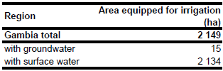
Area equipped for irrigation is 2 149 ha [GM01]. The figures refer to year 1999. The irrigated area is visible in the table below and also can be downloaded as Gambia irrigation areas in PDF or Gambia irrigation areas in Excel.
No sub-national statistics on the extent of irrigated lands have been available, but the location and corresponding area equipped for irrigation of the existing four projects JPSP, RIDEP, SSWC and Lamin/Bakau horticulture was available [GM02]. The outlines of the largest scheme (JPSP) were digitized from satellite imagery [GM03], while the other schemes were incorporated as point features using the positions indicated on [GM02].
Area actually irrigated was 1 400 ha in year 1999 [GM04]. Only 15 ha were irrigated with groundwater from wells and boreholes in the Lamin Horticultural Project and the Bakau Horticultural Project. The other irrigation schemes used surface water provided by pumping from the river or by tidal irrigation [GM04].
References
[GM01]: International Cooperation and Development Fund (ICDF). 1999. Development of tidal irrigation in the Gambia. In: ICDF. 1999 ICDF Annual Report – Special Report. 67-70.
[GM02]: Chancellor, F. 1996. Women in Irrigation: Case studies of schemes in the Gambia, Kenya and South Africa. HR Wallingford, UK. Report no OD/TN 82.
[GM03]: Earth Satellite Corporation. 2004. Landsat GeoCover (2000/ETM+) Edition Mosaics, tile 071-166. Sioux Falls, USA, USGS (available at http://glcfapp.umiacs.umd.edu:8080/esdi/index.jsp).
[GM04]: FAO. 2005. AQUASTAT country profile Gambia, FAO, Rome, Italy.


