AQUASTAT - FAO's Global Information System on Water and Agriculture
Croatia
Sub-national irrigation statistics as compiled by the Agricultural Census 2003 were available for the area actually irrigated during season 2002-2003 and were summing up to 9 275 ha, of which 5 000 ha were used by agricultural households and 4 275 ha by business entities [HR01]. It was assumed that AEI is similar to the irrigated areas reported by the agricultural census report at the county level. Irrigated area at municipality level has been available for agricultural households only. Therefore it was assumed that the share of municipalities on the irrigated area of the counties was equal for agricultural households and business entities.
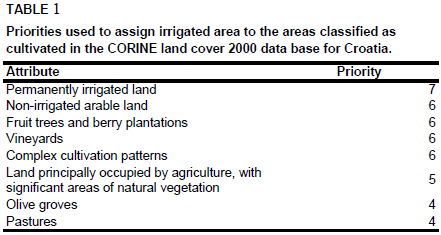
Irrigated area was distributed within the municipalities by assigning area equipped for irrigation to cultivated land as classified by the Corine 2000 land cover data base for Europe [HR02] by using the priorities shown in Table 1. The highest priority was given to polygons classified as permanently irrigated land (212) while olive groves (223) and pastures (231).
The irrigated areas by county are shown in the Table below. The irrigated areas both by region and by municipalities can be downloaded as a Croatia irrigation areas in PDF or Croatia irrigation areas in Excel (two sheets).
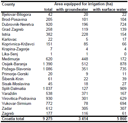
The number of farms irrigated from groundwater, surface water and from water supply networks was reported for each county and per farm size class by the agricultural census report 2003 [HR01]. Area irrigated from groundwater was computed for each farm size class as AEI * N_GW / (N_GW + N_SW) where N_GW was the number of farms irrigated from groundwater and N_SW was the number of farms irrigated from surface water. Next, the sum of area irrigated from groundwater of all farm size classes was computed for each county. AEI irrigated with groundwater computed this way was 3 414 ha.
References
[HR01]: CROSTAT. 2006. Agricultural census 2003. Republic of Croatia - Central Bureau of Statistics (CROSTAT), http://www.dzs.hr/default\_e.htm, 17/08/2009.
[HR02]: EEA. 2005. Corine land cover 2000 - vector by country (CLC2000), version 1. http://dataservice.eea.europa.eu/dataservice/metadetails.asp?id=667, 29/08/2005.


