AQUASTAT - FAO's Global Information System on Water and Agriculture
Hungary
In Hungary the area equipped for irrigation reached its maximum in 1974 at 451 000 ha when the barrage at Kisköre and a dam in Békés were put into operation [HU01]. The area still equipped for irrigation is lower today but the statistics differ significantly dependent on the reference year and the source of information. The irrigable area of the country as reported by EUROSTAT or the Central Statistics Office was 308 110 ha in 2000 [HU02] and about 242 170 ha in 2003 [HU02], [HU03], while statistics of the National Water Authority indicate an area equipped for irrigation of 235 500 ha in 2000 and 208 400 ha in 2003 [HU01]. According to the latter statistics the area equipped for irrigation declined each year within the period 1998 (264 300 ha) to 2004 (159 100 ha). Differences also exist in the statistics referring to the area actually irrigated. EUROSTAT reported an area actually irrigated of 67 100 ha in 2000 and 148 690 ha in 2003 [HU02]. In contrast, the National Water Authority reported actual irrigation areas of 125 300 ha in 2000 and 115 200 ha in 2003 [HU01]. Because of the given uncertainties area equipped for irrigation was estimated for this study by selecting for each county the maximum of the areas reported as irrigable (Central Statistics Office, year 2003) or equipped for irrigation (National Water Authority, years 2001, 2002 and 2004). The total area equipped for irrigation estimated that way is summing up to 292 147 ha and it is visible in the table below and also can be downloaded as Hungary irrigation areas in PDF or Hungary irrigation areas in Excel..
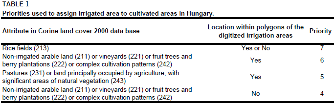
Polygons, showing the irrigation system of Hungary, were digitized from an irrigation map published in an atlas [HU04] and combined to polygons of cultivated land as extracted from the Corine 2000 land cover database for Europe [HU05] by using the priority levels shown in Table 1.
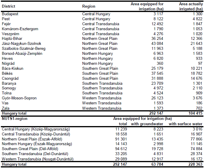
Area equipped for irrigation with groundwater was computed based on the data collected by the EU farm structure survey 2003 as described before. Area actually irrigated per county was computed as average of AAI reported for the period 2003-2009 [HU06]. Total AAI computed that way was summing up to 104 415 ha.
References
[HU01]: Ligetvári, F., Cselotei, L., Kiss, K., Dimény, J., Szilárd, G., Takács-György, K., Kis, S., Helyes, L., Pekár, F. & Bozán, C. 2006. Country report from Hungary. In: Dirksen, W. and Huppert, W. (ed.). Irrigation sector reform in Central and Eastern European countries. Deutsche Gesellschaft für Technische Zusammenarbeit (GTZ), Eschborn, Germany, 161-250.
[HU02]: Statistical Office of the European Communities (EUROSTAT). 2011. Irrigable and irrigated areas. http://epp.eurostat.ec.europa.eu/portal/ page/portal/agri_environmental_indicators/data/ database, 28/11/2011.
[HU03]: Central Statistics Office. 2004. Agriculture in Hungary 2003, Vol. II – Farm structure survey. Tab. 6.6. Budapest, Hungary, 260 pp., http://portal.ksh.hu/, 07/07/2006.
[HU04]: Hungarian Academy of Sciences & Ministry of Agriculture and Food. 1989. National Atlas of Hungary. Map on p. 208. Cartographia, Budapest, Hungary, 389 pp.
[HU05]: EEA. 2005. Corine land cover 2000 - vector by country (CLC2000), version 1. http://dataservice.eea.europa.eu/dataservice/metadetails.asp?id=667, 29/08/2005.
[HU06]: Hungarian Central Statistical Office. 2011. Data on irrigated land area. http://statinfo.ksh.hu/Statinfo/QueryServlet?ha=MN1B05, 15/03/2011.


