AQUASTAT - FAO's Global Information System on Water and Agriculture
Cambodia
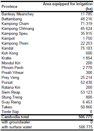
A recent inventory reported 2129 irrigation systems in 15 provinces, covering a total area of 504 675 ha with existing irrigation infrastructure and 164 964 ha of irrigation schemes in the planning or construction phase [KH01]. Irrigated area is 273 767 ha in the wet season and 260 815 ha in the dry season, while 29 907 ha are irrigated in both seasons. The inventory is related to the situation in year 2009 and indicates a strong increase of area equipped for irrigation as compared to former versions of the same inventory reporting areas equipped for irrigation of 323 591 ha in year 2004 [KH02] or 284 177 ha in year 2001 [KH03]. Area equipped for full control irrigation in year 2006 was reported at 353 566 ha [KH04]. The irrigated area of the six provinces not included in the inventory (Preah Vihear, Stung Treng, Ratana Kiri, Mondul Kiri, Koh Kong and Tonle Sap) was reported to be about 2 100 ha in 1990 [KH05], so that the total irrigated area of the country is about 506 775 ha. The irrigated area per province estimated that way is visible in the table below and also can be downloaded as Cambodia irrigation areas in PDF or Cambodia irrigation areas in Excel.
To distribute irrigated area within the country, digital maps of irrigated areas (polygon dataset) related to year 2001 [KH06] and a digital map of irrigation projects (point dataset) related to year 2009 [KH01] were used. Because the digital map of irrigation projects (point dataset) often referred to the position of the headwork (reservoir, weir, sluice structure or pump) it was used for small schemes (fewer than 300 ha) while the polygon dataset was used for large schemes (more than 300 ha). The assumption behind this descision was that small irrigation schemes are located closer to the source of irrigation water while large schemes might be located in a larger distance to the water source. The remainder of the irrigated area was distributed to paddy areas taken from a digital landcover map [KH03].
Area actually irrigated was 317 225 ha or 89.7 percent of area equipped for irrigation in year 2006 [KH04]. The ratio between AAI and AEI reported for year 2006 was applied for year 2009 as well resulting in an AAI of 454 687 ha. Irrigation is completely based on surface water sources (reservoirs, rivers) [KH04].
References
[KH01]: Mekong River Commission Secretariat. 2009. Irrigation dataset 2009. http://portal.mrcmekong.org/, 18/04/2012.
[KH02]: Mekong River Commission Secretariat. 2009. Irrigation dataset 2004. http://portal.mrcmekong.org/, 18/04/2012.
[KH03]: Mekong River Commission Secretariat. 2003. People and the Environment Atlas of the Lower Mekong Basin. CD-ROM. Phnom Penh.
[KH04]: FAO. 2011. AQUASTAT country profile of Cambodia, version 2010. FAO, Rome, Italy.
[KH05]: FAO. 1994. Agricultural development options review (phase I). Rome.
[KH06]: FAO. 2004. Dataset Landuse2000.zip provided by FAO ASIACOVER project.


