AQUASTAT - FAO's Global Information System on Water and Agriculture
Saint Kitts and Nevis
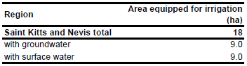
For Saint Kitts and Nevis no information could be found on irrigated areas on sub-national level. In the whole of Saint Kitts and Nevis 18 ha are equipped for irrigation. The figure refers to 1997 [KN01]. The irrigated area is visible in the table below and also can be downloaded as Saint Kitts and Nevis irrigation areas in PDF or Saint Kitts and Nevis irrigation areas in Excel.
The irrigated area within the country was distributed to cropping areas as indicated on the USGS land cover characterization map [KN02].
In Nevis approximately 10 ha of land are irrigated half from groundwater and half from surface water. On Saint Kitts 8 ha land are irrigated mainly from the domestic water supply which is from six surface water intakes (small streams) and five wells [KN01]. Based on this information AEI irrigated with groundwater was estimated to be 50 percent of total AEI.
References
[KN01]: FAO. 2000. AQUASTAT country profile of Saint Kitts and Nevis, version 2000. FAO, Rome, Italy.
[KN02]: USGS. 2001. Global Land Cover Characterization, map version 2, http://edcdaac.usgs.gov/index.html, 10/08/2006.


