AQUASTAT - FAO's Global Information System on Water and Agriculture
Global Map of Irrigation Areas
Lesotho
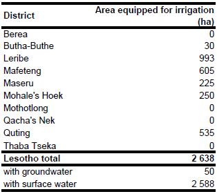
Area equipped for irrigation is 2 637 ha [LS01]. The figures refer to year 1999.
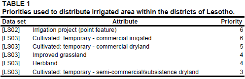
The location and extent of 6 irrigation schemes covering 570 ha were derived from the FAO irrigation map for Africa [LS02]. Additionally 17 areas classified as "Cultivated: temporary - commercial irrigated" covering 726 ha in total were derived from a land cover database for South Africa [LS03]. Areas classified as "Cultivated: temporary - commercial dryland", "Cultivated: temporary - semi-commercial/subsistence dryland", "Improved grassland" or "Herbland" were derived from the same data set. Irrigated area was assigned to those areas using the priorities documented in Table 1, if the areas were located in four zones marked as irrigated on the FAO irrigation map for Africa [LS02]. For the district of Leribe also areas outside these zones were considered.
The irrigated area per district estimated that way is documented in the downloadable Lesotho irrigation areas in PDF or Lesotho irrigation areas in Excel.
Area actually irrigated was only 67 ha in year 1999. While the large scale schemes (mainly sprinkler irrigation) went completely out of operation, small scale irrigation for vegetable production was successful. Rivers are the water source of large scale schemes and water for small scale agriculture and home gardens is extracted from the domestic supply system or from small streams or ponds using pumps. Irrigation potential from groundwater is limited to the area around Maputsoe [LS04]. Based on this information area equipped for irrigation with groundwater was estimated at 50 ha (2 percent) of the total area equipped for irrigation.
References
[LS01]: FAO and World Bank. 1999. Lesotho smallholders irrigation initiative. Exploratory Mission Report.
[LS02]: FAO. 1987 (updated in 2005). Irrigated areas in Africa. FAO, Rome, Italy.
[LS03]: Thompson, M.W. 1999. South African national land cover data set. Council for Scientific and Industrial Research (CSIR), Satellite Applications Centre. CD-ROM, available at: http://www.sac.co.za.
[LS04]: FAO. 2006. AQUASTAT country profile Lesotho. FAO, Rome, Italy.


