AQUASTAT - FAO's Global Information System on Water and Agriculture
Mauritania
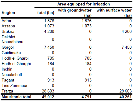
Area equipped for irrigation is 45 012 ha, of which 40 261 ha are located along the Senegal river and 4 751 ha irrigated land is located in 218 oases [MR01]. The figures refer to year 1994. The irrigated area per region estimated that way is visible in the table below and also can be downloaded as Mauritania irrigation areas in PDF or Mauritania irrigation areas in Excel.
The irrigated areas along the Senegal river were digitized from a map published as part of the AQUASTAT country profile [MR02]. The oases were located using the Geographic Name Server of the US National Geospatial-Intelligence Agency (http://gnswww.nga.mil/geonames/GNS/index.jsp). The outlines of the irrigated areas were improved by digitizing cultivated areas along the Senegal river and around the oases by using satellite imagery [MR03].
Area actually irrigated in year 2004 was 22 840. The irrigation areas along the Senegal river are using surface water for irrigation while groundwater is used for irrigation in the oases [MR02].
References
[MR01]: MDRE. 1998. Politiques et stratégies générales pour le développement du secteur rural – Horizon 2010.
[MR02]: FAO. 2005. AQUASTAT country profile Mauritania, FAO, Rome, Italy.
[MR03]: Earth Satellite Corporation, 2004. Landsat GeoCover (2000/ETM+) Edition Mosaics, tiles 071-167, 071-168, 071-179, 071-180 and 071-181. Sioux Falls, USA, USGS (available at http://glcfapp.umiacs.umd.edu:8080/esdi/index.jsp).


