AQUASTAT - FAO's Global Information System on Water and Agriculture
Namibia
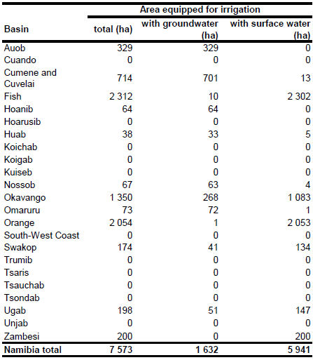
Area equipped for irrigation is 7 573 ha [NA01]. The figures refer to year 2002. Irrigated area per river basin was available for year 1999 and adds up to 7 318 ha [NA02]. The statistics presented in both reports were combined to an inventory of schemes irrigating with groundwater [NA03] to compute area equipped for irrigation per basin for the year 2002. Irrigated area for the following basins were derived from report [NA02]: Orange (2 054 ha), Fish (2 312 ha), Nossob (67 ha), Swakop (174 ha), Omaruru (73 ha), Ugab (198 ha), Huab (38 ha) and Hoanib (64 ha). According to the project-based statistics reported in [NA01] irrigated area of Zambezi basin was set to 200 ha and that one of Okavango basin and its upstream sub-basins to 1 350 ha. Area equipped for irrigation in the Auob basin was set to 329 ha according to [NA03]. The total area equipped for irrigation as assigned that way adds up to 6 859 ha and the remaining area of 714 ha was assigned to the Cunene basin and the Cuvelai area. The irrigated area per basin estimated that way is visible in the table below and also can be downloaded as Namibia irrigation areas in PDF or Namibia irrigation areas in Excel.
The location and command area of five large irrigation schemes was derived from the FAO irrigation map for Africa [NA04]. The shapes of the boundaries of the digitized irrigation areas were improved by using satellite imagery [NA05]. The total area equipped for irrigation in these schemes was reported to be 5 350 ha. The remaining irrigated area was assigned to small scale irrigated areas fed by ground water as indicated on an irrigation map available in the AQUASTAT library and to from an groundwater inventory related to the year 1999 [NA03].
Location and extent of schemes irrigating with groundwater was derived from an inventory related to year 1999 [NA03]. Total AEI irrigated with groundwater according to this inventory was 1 632 ha or 22 percent of total AEI. The sum of AEI irrigated with groundwater was then computed for each of the 23 basins contained in version 4 of the GMIA as subnational units of Namibia. It was assumed that AAI was similar to AEI.
References
[NA01]: FAO. 2005. AQUASTAT country profile Namibia, FAO, Rome, Italy.
[NA02]: Windhoek Consulting Engineers (WCE). 2000. Analysis of Present and Future Water Demand in Namibia.
[NA03] Christelis, G. and Struckmeier, W. (eds.). 2001. Groundwater in Namibia – an explanation to the hydrogeological map. Dept. of Water Affairs, Division Geohydrology, Geological Survey of Namibia, Namibia Water Corporation, Federal Institute for Geosciences and Mineral Resources, Windhoek, Namibia and Hannover, Germany, 128 pp.
[NA04]: FAO. 1987 (updated in 2005). Irrigated areas in Africa. FAO, Rome, Italy.
[NA05]: Earth Satellite Corporation. 2004. Landsat GeoCover (2000/ETM+) Edition Mosaics, tiles 071-680, 071-681, 071-682, 071-687, 071-688, 071-689 and 071-694. Sioux Falls, USA, USGS (available at http://glcfapp.umiacs.umd.edu:8080/esdi/index.jsp).


