AQUASTAT - FAO's Global Information System on Water and Agriculture
Oman
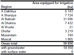
Area equipped for irrigation according to the agricultural census 2004 was 58 850 ha [OM01]. Area equipped for irrigation per region in year 2004 was derived from the census report [OM02]. Most of the irrigated land was located in the Al Batinah coastal plain (31 696 ha) as shown in the table below and in the downloadable Oman irrigation areas in PDF or Oman irrigation areas in Excel.
The cultivated area, which is completely under irrigation [OM01], was digitized from Landsat satellite imagery [OM03].
Groundwater extracted from wells or springs is the only source of irrigation water [OM01]. Area actually irrigated in year 2004 was assumed to be similar to area equipped for irrigation because of the high harvested area of irrigated crops (63 607 ha in year 2004) and the high share of perennial crops (83 percent of the total harvested area).
References
[OM01]: FAO. 2013. AQUASTAT country profile of Oman, version 2008. FAO, Rome, Italy.
[OM02]: Ministry of Agriculture and Fisheries. 2005. Agricultural census 2004. http://omanagriculture.net/Pages/PageCreator.aspx?lang=AR&I=0&DId=0&CId=0&CMSId=800645, 20/01/2013.
[OM03]: Earth Satellite Corporation. 2004. Landsat GeoCover (2000/ETM+) Edition Mosaics, tiles 071-308, 071-318, 071-319 and 071-320. Sioux Falls, USA, USGS, http://glcfapp.umiacs.umd.edu:8080.


