AQUASTAT - FAO's Global Information System on Water and Agriculture
Peru
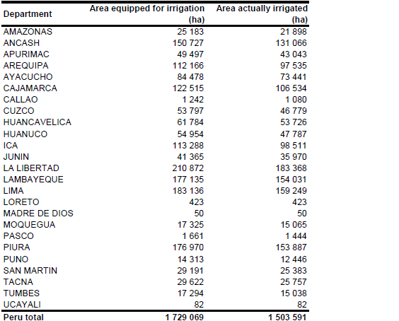
Area equipped for irrigation was reported at 1 729 065 ha [PE01]. The figures originate from the last agricultural census and refer to year 1994. Census statistics down to the district level were used for the departments of Arequipa, Ica, Lambayeque, Loreto, Madre de Dios, Moquegua, Tacna and Ucayali while for the rest of the country statistics at province level were used. The total area equipped for irrigation in the 461 statistical units considered in Peru was summing up to 1 729 069 ha. The small difference of 4 ha to the figures reported at the national scale obviously originated from rounding errors and was thus neglected. The irrigated areas by department are shown in the Table below. The irrigated areas both by department and by district can be downloaded as Peru irrigation areas in PDF or Peru irrigation areas in Excel (two sheets).
Irrigated area was assigned to 19 projects indicated of an irrigation map of the region around Lake Titicaca [PE02]. Additionally cultivated areas along the arid coastal zone were digitized from satellite imagery [PE03] and area equipped for irrigation was assigned to these polygons. The remaining irrigated area was assigned to cells classified on the GLC2000 land cover map for South America [PE04] as agriculture (intensive) or mosaics of agriculture and other land uses.
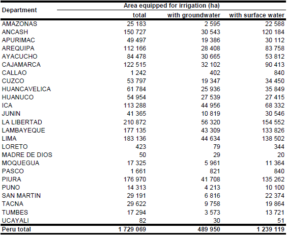
Irrigated area from wells, rivers, lakes, springs, reservoirs and combinations of these water sources were derived for each of the 193 provinces from the agricultural census database [PE01]. Irrigated area from groundwater was computed as the sum of irrigated area from wells, springs and half of the irrigated area of locations irrigated from both, wells and rivers. Total AEI irrigated with groundwater computed this way was 489 948 ha while AEI irrigated with surface water was 1 239 118 ha. AAI was computed based on the ratio between AAI and AEI available at the department level for year 1992 [PE05], resulting in a total AAI of 1 503 591 ha.
References
[PE01]: INEI. 2009. III Censo Nacional Agropecuario 1994. Instituto Nacional de Estadística e Informática (INEI), Lima, Peru, http://www1.inei.gob.pe/BancoCuadros/bancocuadro.asp?p=3, 25/08/2009.
[PE02]: UNEP and Organización de los Estados Americanos. unknown. Diagnostico Ambiental del Sistema Titicaca – Desaguadero – Poopo - Salar de Coipasa (Sistema TDPS) Bolivia-Peru. Report available in the AQUASTAT-library.
[PE03]: Earth Satellite Corporation. 2004. Landsat GeoCover (2000/ETM+) Edition Mosaics. Tiles 071-594, 071-595, 071-596, 071-600, 071-601, 071-602 and 071-612. USGS, Sioux Falls, USA, http://glcfapp.umiacs.umd.edu:8080, 20/08/2006.
[PE04]: Eva, H.D., de Miranda, E.E., Di Bella, C.M., Gond, V., Huber, O., Sgrenzaroli, M., Jones, S., Coutinho, A., Dorado, A., Guimarães, M., Elvidge, C., Achard, F., Belward, A.S., Bartholomé, S., Baraldi, A., De Grandi, G., Vogt, P., Fritz, S. & Hartley, A. 2003. The land cover map for South America in the year 2000. GLC2000 database, European Commision Joint Research Centre, http://www-gem.jrc.it/glc2000, 10/08/2006.
[PE05]: DGAS. 1992. Estudio Básico Situacional de los Recursos Hídricos del Perú. Dirección General de Aguas y Suelos (DGAS), Ministerio de Agricultura, Lima, Peru, 335 pp.


