AQUASTAT - FAO's Global Information System on Water and Agriculture
Palestine
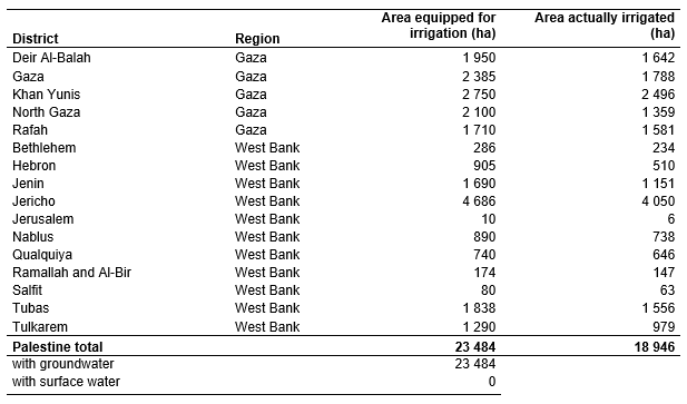
Area equipped for irrigation was about 24 000 ha in year 2003 [PS01], while the extent of irrigated agricultural land varied between 15 300 ha and 17 600 ha in period 2002 – 2008 [PS02]. Subnational statistics of AEI were not available. AEI per district was therefore estimated by selecting for each district the maximum of area actually irrigated reported for period 2002 – 2008 [PS02]. Based on the methodology described in the section on Israel, the irrigated area located in enclosed Israeli settlements was estimated to be 3 244 ha. Total AEI computed this way for the Palestine was 23 484 ha as shown in the table below, also downloadable as Palestine irrigation areas in PDF or Palestine irrigation areas in Excel.
The irrigated areas were digitized from a land-use map [PS03]. In addition, satellite imagery was used to map schemes developed more recently [PS04]. The extent of the digitized irrigated areas in the districts Tulkarem, Qualquiya and Salfit was smaller than the AEI calculated from the statistics. Therefore, the remaining AEI was assigned in these districts to areas classified as rainfed cropland in the regional Globcover landcover classification for North Africa [PS05].
Irrigation is completely based on groundwater resources (wells in the Gaza Strip, wells and springs in the West Bank) [PS01]. Area actually irrigated was computed as the mean of the AAI reported for each district in period 2002 – 2008 [PS02].
References
[PS01]: FAO. 2012. AQUASTAT country profile of the Occupied Palestinian Territory, version 2008. FAO, Rome, Italy.
[PS02]: Palestinian Central Bureau of Statistics. 2003-2008. Agricultural Statistics 2002/2003 – 2007/2008. http://www.pcbs.gov.ps/pcbs\_2012/Publications.aspx, 04/12/2012.
[PS03]: Universität Tübingen. 1993. Tübinger Atlas des Vorderen Orients (TAVO), Plate AX7. Reichert, Germany, Wiesbaden.
[PS04]: Earth Satellite Corporation. 2004. Landsat GeoCover (2000/ETM+) Edition Mosaics, tile 071-272. Sioux Falls, USA, USGS, http://glcfapp.umiacs.umd.edu:8080.
[PS05]: POSTEL. 2008. GLOBCOVER landcover classification, Version 2.2, North Africa. Globcover database. http://toyo.mediasfrance.org/?GLOBCOVER, 24/03/2009.


