AQUASTAT - FAO's Global Information System on Water and Agriculture
Togo
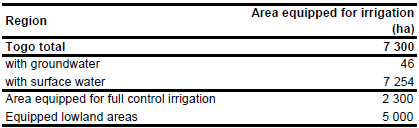
Area equipped for irrigation is 7 300 ha [TG01]. The figures refer to year 1996. The irrigated area is visible in the table below and also can be downloaded as Togo irrigation areas in PDF or Togo irrigation areas in Excel. Sub-national statistics on areas equipped for irrigation were available for the full/partial control areas (2 300 ha) only, but were missing for equipped wetlands (5 000 ha). Therefore the sub-national statistics could not be used.
Irrigated area was assigned to 6 irrigation projects (point data) as derived from the FAO irrigation map for Africa [TG02]. The total area equipped for irrigation in these schemes was 2 900 ha. The remaining area was assigned to 4 irrigation areas (polygon data) derived from the same map.
Area actually irrigated was 86 percent of the area equipped for irrigation (6 278 ha) in year 1996 while area equipped for irrigation with groundwater was 2 percent of the area in full/partial control schemes (46 ha) in year 1990 [TG01].
References
[TG01]: FAO. 2005. AQUASTAT country profile Togo, FAO, Rome, Italy.
[TG02]: FAO. 1987 (updated in 2005). Irrigated areas in Africa. FAO, Rome, Italy.


