AQUASTAT - FAO's Global Information System on Water and Agriculture
Tajikistan
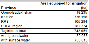
Area equipped for irrigation was 742 051 ha in year 2008 [TJ01]. Subnational statistics have been available for four regions as visible in the table below, also downloadable as Tajikistan irrigation areas in PDF or Tajikistan irrigation areas in Excel.
The irrigated areas were digitized from a map showing irrigated areas in the Aral Sea Basin [TJ02]. The shape of the boundaries of the irrigated areas was then adjusted using satellite imagery [TJ03]. The digitized irrigated areas were combined with irrigated cropland derived from the Globcover regional classification for Central Asia [TJ04]. Irrigated area was then assigned with the highest priority to pixels being irrigated according to both data sources and after that, if required, to pixels that were either covered by the digitized irrigated areas or classified as irrigated by Globcover.
Area actually irrigated was 674 416 ha in year 2008. Area equipped for irrigation with groundwater was 32 500 ha in year 2009 while 13 075 ha were irrigated with mixed surface and groundwater [TJ05]. Therefore total area equipped for irrigation with groundwater was set to 39 038 ha.
References
[TJ01]: Agency on land, geodesy and cartography under Government of the Republic of Tajikistan. 2008. Annual land use report in Republic of Tajikistan.
[TJ02]: Unknown. Aral Sea Basin 1:2,500 000 - administrative boundaries and irrigated areas. Map available in the FAO-AGL library.
[TJ03]: Earth Satellite Corporation. 2004. Landsat GeoCover (2000/ETM+) Edition Mosaics, tiles 071-344, 071-345 and 071-360. Sioux Falls, USA, USGS, http://glcfapp.umiacs. umd.edu:8080.
[TJ04]: ESA. 2008. Regional Globcover Land Cover – Central Asia. Version 2.2. http://postel.mediasfrance.org/en/DOWNLOAD/, 24/03/2009.
[TJ05]: FAO. 2013. AQUASTAT Country Statistics.


