AQUASTAT - FAO's Global Information System on Water and Agriculture
Tunisia
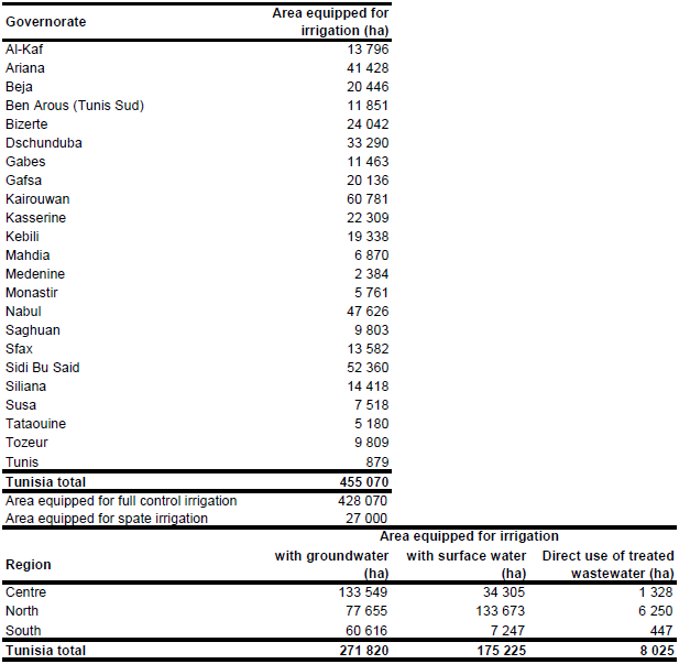
Area equipped for irrigation for the 23 governorates was available for year 2000 and added up to 394 063 ha. Area equipped for irrigation in full/partial control schemes was 366 993 ha while spate irrigation areas covered 27 070 ha [TN01]. Area equipped for irrigation in full/partial control schemes increased to 428 000 ha in year 2006 [TN02] with 49.5 percent in the North, 36.2 percent in the Centre and 14.4 percent in the South. Area equipped for irrigation in full/partial control schemes per governorate was scaled so that the sum of the areas in the governorates was similar to the statistics reported for the entire region. Total area equipped for irrigation per governorate was then computed by adding the spate irrigation areas reported for year 2000. The irrigated area per governorate estimated that way is visible in the table below and also can be downloaded as Tunisia irrigation areas in PDF or Tunisia irrigation areas in Excel.
The location and command area of 18 small scale irrigation projects was derived from the FAO irrigation map for Africa [TN03] while the large scale irrigation areas were digitized from several irrigation maps ([TN04], [TN05] and [TN06]). Finally the shapes of the boundaries of the digitized irrigation areas were improved by using satellite imagery [TN07].
Area actually irrigated was 405 000 ha in year 2005 [TN02]. Area equipped for irrigation with groundwater and with surface water was computed for the three regions North, Centre and South from another report [TN08]. The computed country totals agree well with statistics reported in the AQUASTAT country profile [TN01].
References
[TN01]: DGPDIA - S/D STAT. 2000. Résultats de l'enquête sur les périmètes irrigués en intensif. Ministère de l'Agriculture, de l'Environnement et des Ressources en Eau.
[TN02]: Government of Tunisia. 2008. Rapport d’investissement par pays Tunisie. High-level conference on water for agriculture and energy in Africa: the challenges of climate change, Sirte, Libyan Arab Jamahiriya, December 15-17, 2008, http://www.sirtewaterandenergy.org/, 18/08/2009.
[TN03]: FAO. 1987 (updated in 2005). Irrigated areas in Africa. FAO, Rome, Italy.
[TN04]: Achenbach, H. 1994. Tunesien – Zur Konkurrenz der Wassernutzung und der wasserabhängigen Wirtschaftszweige. In H. Popp & K. Rother, eds. Die Bewässerungsgebiete im Mittelmeerraum, map on p. 167. Passau, Germany, Passavia Universitätsverlag.
[TN05]: Unknown. Irrigation areas of Tunisia, map available from the AQUASTAT library.
[TN06]: Framji, K., Garg, B., Luthra, S. (1983): Irrigation and Drainage in the World, Volume III, p. 1366, ICID, New Delhi, India.
[TN07]: Earth Satellite Corporation, 2004. Landsat GeoCover (2000/ETM+) Edition Mosaics, tiles 071-219 and 071-220. Sioux Falls, USA, USGS (available at http://glcfapp.umiacs.umd.edu:8080/esdi/index.jsp).
[TN08]: AGRIDEV. 2009. Agriculture-périmètres irrigués. AGRIDEV Consulting team-Tunisia, http://www.agridev.net/content/view/283/61/, 28/08/2009.


