AQUASTAT - FAO's Global Information System on Water and Agriculture
Türkiye
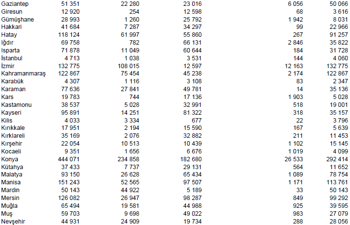
Total area equipped for irrigation was 5 280 000 ha in year 2008 [TR01]. AEI per province was derived from the Village Survey of the Agricultural Census 2001 [TR02]. Total AEI according to this survey was 5 215 144 ha and it is visible in the table below, also downloadable as Turkey irrigation areas in PDF or Turkey irrigation areas in Excel.
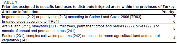

Growing areas of irrigated crops and paddy rice cultivation areas were derived from the Corine Landcover Classification 2006 [TR03]. Additional irrigated areas were digitized from a land-use map [TR04]. The outlines of digitized polygons were adjusted by using satellite imagery [TR05]. In the provinces of Karabük, Giresun, Erzurum, Tunceli, Bingöl and Bitlis AEI reported by the census statistics was larger than the extent of irrigation schemes derived from Corine or digitized from land use maps. Therefore, irrigated land was also assigned to regions classified by the Corine Landcover Classification 2006 as rainfed cropping area by using the priorities shown in Table 1.
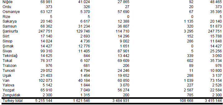
AAI and the percentage of AAI irrigated by groundwater, surface water and non-conventional water sources were derived from the Household Survey of the Agricultural Census 2001 [TR06]. It was assumed that areas irrigated with water extracted from wells and springs represented irrigation with groundwater, areas irrigated with water extracted from streams, lakes, artificial lakes and dams represented irrigation with surface water sources and areas irrigated with water from other sources represented irrigation with non-conventional water sources. The percentage of irrigated area supplied by groundwater was only 19 percent according to the statistics provided by the General Directorate of State Hydraulic Works (DSI) [TR01] and reported by the FAO AQUASTAT country profile [TR07] but 48 percent according to the agricultural census information collected at the household level [TR06]. However, total irrigated area according to the Household Survey was only 3.5 million ha. As a compromise it was therefore decided to assign the difference between the irrigated area reported by the Household Survey report [TR06] and the AEI derived from the Village Survey [TR02] completely to AEI irrigated with surface water. This procedure resulted in a total AEI irrigated with groundwater of 1 621 546 ha (31 percent of total AEI), an AEI irrigated with surface water of 3 484 931 ha (67 percent of total AEI) and an AEI irrigated with water from non-conventional water sources of 108 668 ha (2 percent of total AEI).
References
[TR01]: DSI. 2009. Turkey water report 2009. General Directorate of State Hydraulic Works (DSI), Ankara, Turkey, http://www2.dsi.gov.tr/english/pdf\_files/TurkeyWaterReport.pdf, 07/12/2012.
[TR02]: Turkish Statistical Institute. 2012. Agricultural Census 2001. General Agricultural Census Village Information Survey Results, Table: Land use, http://www.turkstat.gov.tr/ PreIstatistikTablo.do?istab_id=286, 07/12/2012.
[TR03]: EEA. 2012. Corine Land Cover 2006 seamless vector data - version 15. http://www.eea.europa.eu/data-and-maps/data/ds\_resolveuid/f7d1b28c05ce9810df31852becd 1c645, 07/04/2012.
[TR04]: Universität Tübingen. 1993. Tübinger Atlas des Vorderen Orients (TAVO), Plate AX2. Reichert, Germany, Wiesbaden.
[TR05]: Earth Satellite Corporation. 2004. Landsat GeoCover (2000/ETM+) Edition Mosaics, tiles 071-261, 071-262, 071-273, 071-274, 071-288, 071-289, 071-300 and 071-301. Sioux Falls, USA, USGS, http://glcfapp.umiacs.umd.edu:8080.
[TR06]: Turkish Statistical Institute. 2012. Agricultural Census 2001. General Agricultural Census Agricultural Holdings (Household) Survey Results, Table: Number of agricultural holdings using irrigation and irrigated area by irrigation sources, http://www.turkstat.gov.tr/ PreIstatistikTablo.do?istab_id=297, 07/12/2012.
[TR07]: FAO. 2012. AQUASTAT country profile of Turkey, version 2008. FAO, Rome, Italy.


