AQUASTAT - FAO's Global Information System on Water and Agriculture
Uganda
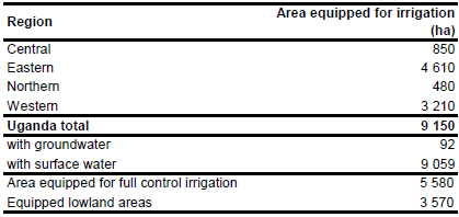
Area equipped for irrigation is 9 150 ha [UG01]. The figures refer to year 1998. Area equipped for irrigation in full or partial control irrigation [UG02] was 5 580 ha, while the extent of equipped lowlands was 3 570 ha [UG01]. The irrigated area estimated that way is visible in the table below and also can be downloaded as Uganda irrigation areas in PDF or Uganda irrigation areas in Excel.
The location and command area of 15 irrigation projects was derived from the FAO irrigation map for Africa [UG03]. The total area equipped for irrigation in these schemes was 8 120 ha. The remaining area was assigned to areas classified as irrigated, rice or sugar cane in the FAO AFRICOVER data base [UG04].
Area actually irrigated was 5 900 ha in year 1998 [UG01]. Based on the qualitative information contained in the AQUASTAT country report [UG01] and groundwater use in neighbouring countries (Cameroon, Congo) it was assumed that only 1 percent of the irrigation area has groundwater supply.
References
[UG01]: FAO. 2006. AQUASTAT country profile Uganda, FAO, Rome, Italy.
[UG02]: IPTRID. 1998. Irrigation sub-sector review, Uganda. Draft Report. [UG03]: FAO. 1987 (updated in 2005). Irrigated areas in Africa. FAO, Rome, Italy. [UG04]: FAO. 2005. AFRICOVER, Uganda - Spatially Aggregated Multipurpose Landcover database. FAO, Rome, Italy, http://www.africover.org, 13/12/2004.


